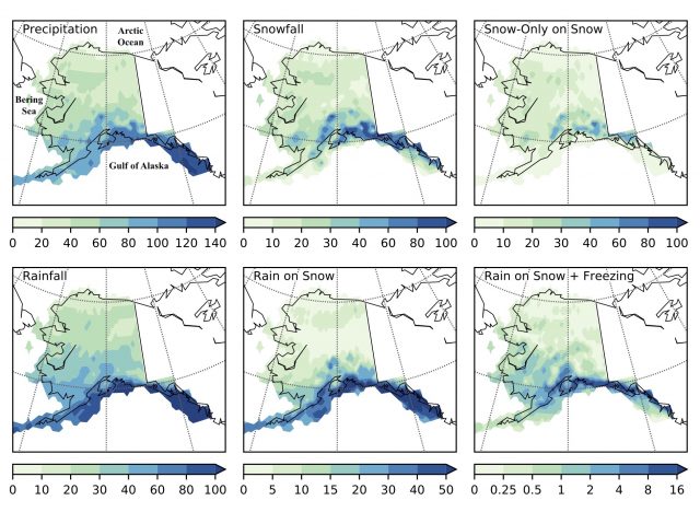
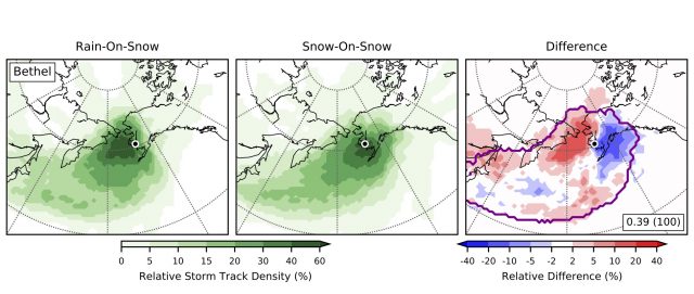
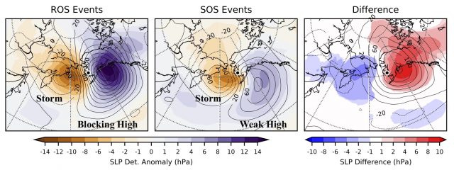
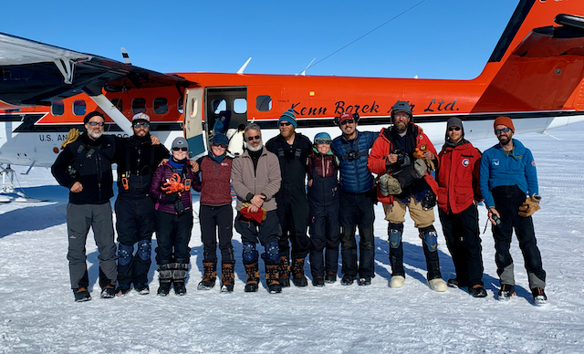
Wooster Geologist in Hungary and Slovakia

Štrba, Slovakia — Today our field party drove from Budapest through northern Hungary into Slovakia. The day was brilliantly sunny. Our first stop was at a holy well near Szentkút, Hungary, to examine Miocene fossils (mostly bryozoans). High up in the surrounding hills is a shelf where the mrl is best exposed. Long ago a community of monks established living quarters and a chapel by carving the soft stone. Our outcrop was well exposed because of their work.

Our leader Kamil emerging from one of the stone rooms.

There is some sedimentology and structural geology going on here as well as paleontology. Inside one of the rooms the walls cut through soft-sediment deformation and a normal fault oblique to the corner.

The bryozoans are numerous and well-preserved in the stone walls.

Szentkút was especially religious on the day we visited. It was Pentecost for the Greek Catholic faith, so there were large crowds and colorful clerics around the shrines. I hope we were not noticed walking through.

In case you wondered what a border crossing between Hungary and Slovakia looks like.

We next stopped in Fiľakovo, a Slovakian town with a magnificent castle. We will see a lot of castles on this trip, and as Kamil told us, most were built in the 13th century and destroyed in the 16th. This castle was most impressive to me because of the bedrock it is built on: a Miocene ignimbrite, which is a rock resulting from volcanic eruptions. Most geologists would call it a welded tuff. he Miocene volcanoes still ring the town as wooded hills.

A close view (with my field trip roommate Hans Arne Nakrem for scale) shows the complex stratigraphy of the unit.

There are numerous volcanic bombs and other volcaniclastic bits in the welded tuff.

A view of the town from the castle. When the Ottoman Turks were here I’m sure they couldn’t imagine having a Catholic church in sight.

One of the Miocene volcanoes.

Our last stop of the day was near Štrba, Slovakia, for this small outcrop of Miocene bryozoan marl. ots of high grass.

The High Tatra Mountains of northern Slovakia and southern Poland are now in view! We’ll look at these in more detail tomorrow.


Posted in Uncategorized | Tagged , , , , , , | Leave a comment

A Wooster Geologist in Budapest

Budapest, Hungary — This month I have the privilege of attending the 18th meeting of the International Bryozoology Association (IBA) in Liberec, The Czech Republic. As is the tradition, there is a pre-meeting field trip, this time to sites in four countries: Hungary, Slovakia, Austria, and The Czech Republic. There are 11 participants in a chartered bus setting off for a week of fossils and history, led by that excellent bryozoologist and good fellow, Kamil Zágoršek. We begin in Budapest with a classic view of the beautiful Danube River as it flows past our hotel. It is sunny and very warm.

There will be plenty of fancy views, but fr the local feel I want to include an image of just a regular Budapest block near our hotel.

Our first stop was at the Hungarian Natural History Museum in Budapest. It was established in 1802, and as our guiding museum scientist told us, the first 154 years were “normal” (at least for this part of the world), but in 1956, during the Soviet suppression of the Hungarian Revolution, a Russian tank fired into the museum, causing extensive damage. Shortly afterwards a Soviet jet dropped an incendiary bomb on the building. Tens of thousands of specimens were lost in the ensuing fires. The collections have still not recovered the numbers they had prior to the attacks.

Bryozoologists all love natural history museums, especially when we can open the drawers.

This particular museum doesn’t have a lot of bryozoans (a few drawers), but does have extensive vertebrate collections, fossil and modern.

Every natural history museum I’ve visited has a basement floor with hundreds of stuffed animals that are no longer in fashion for public displays.

The public part of the museum is diverse and well organized. I wouldn’t use Noah’s Ark as the initial theme for biodiversity, but it works here!

Our first locality was an Eocene bryozoan-rich marl site near Mátyashegy, Hungary, just outside Budapest. The bryozoans are numerous, but tiny little critters for my camera!

The second site is another bryozoan marl and sand, this one Miocene near Fót on the outskirts of the Budapest city center.

Our first group dinner was in the center of Budapest, ironically at an American restaurant. Our leader Kamil is at the head of the tables.

That evening we walked up Gellért Hill in the center of the city to see the amazing lights. My phone camera wasn’t up to the challenge, but you may be able to make out Buda Castle here.

At the top of the hill is a massive Soviet monument originally dedicated to the Soviet defeat of the Nazis in Budapest in 1945. The tall structure is the Liberty Statue. After the Soviets left the country (in 1989), the Hungarians removed some statuary and rededicated the monument to “those who sacrificed their lives for the independence, freedom, and prosperity of Hungary”, which includes thousands killed by the Soviets during their occupation.

On my first day in Budapest I was alone, so I visited the former Hungarian Secret Police headquarters, now a museum called The House of Terror. It is a grim but highly informative look at Hungarian life under fascist and then communist rule.

Photography was not allowed inside. The outside of the building has what seems to be an endless row of photos of Hungarians who were executed here. Quite moving. In one of the displays inside is a wall of photographs and names of the “victimizers”, the agents (Russian and Hungarian) who perpetrated these crimes. The point is that we don’t see these atrocities as simply results of a system but also the actions of individuals.

This artwork outside the museum entrance is simply called “Iron Curtain“. The link has a full description and more images.


Posted in Uncategorized | Tagged , , | Leave a comment

Wooster and Dickinson students team up for geochemistry research

[Wooster, OH] – A team of students from Wooster and Dickinson are working together on geochemistry research this summer. We’re using the compositions of Earth materials to understand geologic processes. Our main goal is to study the formation of volcanic ridges that were erupted beneath glaciers in Iceland, but we have a few other projects that we’ll be working on, too.  Thanks to Sherman Fairchild funding, we have 8 weeks to learn a lot of different lab techniques and travel to Iceland to get more samples.

We began our work with a weeklong marathon of preparing samples for analysis in the Wooster X-ray and Dickinson SEM labs.

Kendra and Layali prepared geochemical samples by melting powdered rocks and forming them into glass disks.

Marisa is examining samples of volcanic glasses under the microscope, selecting the freshest chips.

Kendra and Hannah are in the first stages of polishing the fresh glass chips so that they are perfectly smooth. This will let us analyze their compositions on Dickinson’s scanning electron microscope. We can also use the polished glass chips to measure the water contents later in the project.

Layali is tracing images of thin sections. We’ll use the tracings to do some quantitative mineralogical analyses.

It looks she is having fun doing all of this hard work!

The team has been working so hard that they have needed reminders to take breaks. So what to do on a break? How about a game of lab-bench-dino-mancala?


Posted in Uncategorized | Tagged , , , , , , , , | 1 Comment

Dundee Falls: A beautiful waterfall in northeastern Ohio

Dundee, Ohio — One of the joys of summer for a geologist is the time to take short trips in the neighborhood to explore nature. This afternoon Greg Wiles, Nick Wiesenberg, Greg’s adventurous dog Arrow, and I drove about 45 minutes into Tuscarawas County to visit Dundee Falls, which is in the Beach City Wildlife Area. It was a gorgeous day. The falls are formed by a creek rushing into a gorge walled by the Dundee Sandstone (= Massillon Sandstone), part of the Pottsville Series of Upper Carboniferous age. I hadn’t heard of this place until Alexis Lanier (’20) recommended it.
The vertical sandstone walls are impressive. This particular face is used by rock climbers. I learned on this visit that the climbers occasionally scrub the cliff face with wire brushes to remove slippery moss and the inevitable graffiti.

The sandstone shows several sedimentary structures, including dramatic cross-bedding. These are like lateral accretion deposits from meandering streams in a delta complex.

The sandstone has layers of iron oxide concretions reminiscent of the Moqui Marbles we saw in the Navajo Sandstone on our Utah Expedition this spring.

Nick”s right hand is on a quartz-pebble conglomerate within the sandstone. These core beds are common throughout the Pottsville Series. They likely represent braided stream deposits and classic molasse. The reddish color is what remains of spray-painted graffiti.

The unscrubbed, unpainted walls host a wonderful moss-fern flora.

One of the goals of this hike was to determine the ages of the oldest trees. Nick and Greg (and Arrow) are here scoping out the woods for the largest oak trees.

Greg and Nick worked hard inserting their coring devices. The process makes some incredible squawking noises as the bit is screwed into the tight wood. I also learned that taking the corer out of the tree can be much harder than putting it in! So far the dendrochronology team found trees only about 200 years old, which is too young to interest them.

Arrow the Dog was a great companion as always! He seems to have a very good time on these outings.

Update from Dr. Wiles, ace dendrochronologist: “Nick worked up the five cores we took and below is the Dundee Ring Width Series – inner ring 1823, second growth. Looks like a slow release up until 1900 and then a big release – selective logging and the big logging at 1900? Maybe the quarry was set up ~1900.”


Posted in Uncategorized | Tagged , , , | 5 Comments

Constructive & Destructive Landforms at Mount Rainier National Park

One common frame used to introduce landforms in introductory Geology courses is the idea of constructive and destructive forces that create and change them. (See, for example some K-12 resources here and here.) Constructive processes like the the deposition of sediment and extrusion of lava build landforms by adding material at the surface. Destructive processes like weathering and erosion and explosive volcanism shape the surface by removing material.

If you go to the Paradise Visitor Center in Mount Rainier National Park, you can observe this dichotomy at work just by comparing the north and south. Looking to the north is the park’s namesake: Mount Rainier. The smooth, rounded shape of this composite stratovolcano is primarily the result of layered ash, rubble, and lava over the past 500,000 to a million years, piling up over 14,000 ft high (NPS). There are glaciers eroding the flanks of Mount Rainier, but the recent volcanism of the past few thousand years means the overall shape is more reflective of volcanism than glaciation.

View to the North: Mount Rainier

Contrast this with the view to the south. Rather than a single smooth and rounded profile, the Tatoosh Range is characterized by several jagged peaks with names like “The Castle” and “Pinnacle Peak”. This mountain range is the result of extensive weathering of an ancient pluton, which was originally emplaced in the Miocene (14 million years ago; USGS 1963; Mattinson 1977). The Tatoosh pluton was exposed at the surface and actively eroded by Pleistocene glaciers long before Mount Rainier existed.  With millions of years of erosion at work, destructive forces are more obvious in the Tatoosh Range than on Mount Rainier. It displays classic glacial features like the horn of Pinnacle Peak, the col between Plummer Peak and Denman Peak, and the converging U-shaped troughs below Plummer Peak.

View to the South: Tatoosh Range (Paradise Visitor Center in foreground).

Posted in Uncategorized | Tagged , , , , , , | Leave a comment

Lots of Rain v. Many Rainy Days

The other day while on the phone with my sister, she complained about how bad the weather was. “It’s rained like every day since April 1st” was the statement. That was an exaggeration, so she then modified that statement to say it’s been really wet this spring, and she’s had few opportunities to let the boys play outside in the sun. So then I wondered… is she right? Or is she just participating in a favorite past time of complaining about the weather? She lives north of Boston, so I decided to take a look at the data from a long-running station at Lowell, Massachusetts.

Distribution of total precipitation between April 1 and May 10 in Lowell, Massachusetts

It’s true that 2019 has had a wet spring. Of the 127 years of data at Lowell, 9 years had enough missing data I had to toss them.  That leaves 118 years.  Of those, 2019 has seen the 12th most precipitation between April 1 and May 10 (7.73 inches; the 91st percentile). However, my sister has only lived near Lowell for about 15 years, and in those 15 years, 2019 ranks 5th… so above average, but nothing special.  In fact, neither of her sons has experienced fewer than 6 inches of rain from April 1 through May 10… all they know is wet springs!

Before I called her back to tell her she’s exaggerating, I decided to dig a little deeper.  You see, my sister didn’t actually say there’s been a lot of rain; she said there had been many rainy days. That’s different. If we track the percentage of days on which rain (sometimes with snow) fell in Lowell since April 1, we find that my sister is on to something.  It has rained 25 days — about 62% of the days since April 1 — and that is a record.  Yup, in 118 years Lowell has never had so many rainy days between April 1 and May 10.  My sister’s smart, but I didn’t expect she’d be that good.

Distribution of the days between April 1 and May 10 with precipitation greater than 0.01 inches in Lowell, Massachusetts

Anyway, the lesson here is that my sister, like many people, would rather have a lot of rain on a few days than a little rain on many days. It’s not the rain so much as lack of sun that gets to people. This is partly why a city like Seattle (36 inches/year) is famous for being rainy even though cities like Cleveland (39 inches/year), Boston (44 inches/year), and New York City (50 inches/year) all receive more precipitation.  It’s not that Seattle gets a lot of rain; it’s that it’s often raining. Seattle has 152 days with precipitation a year, but Boston only has 126, and New York has only 122. Think about that — NYC gets 38% more precipitation but 30 extra days without any precipitation!

Total annual precipitation and number of days with greater than 0.01 inches water equivalent of precipitation in four US cities

Cleveland, for the record, has 154 days with precipitation a year on average thanks to it frequent lake effect snow. All data are from NOAA’s Climate Data Online.

Posted in Uncategorized | Tagged , , , , , | 3 Comments

New paper on crinoids of the Kalana Lagerstätte (Early Silurian) of central Estonia

Bill Ausich (The Ohio State University), Oive Tinn (University of Tartu) have a paper that has just appeared:

Ausich, W.I., Wilson, M.A. and Tinn, O. 2019. Kalana Lagerstätte crinoids: Early Silurian (Llandovery) of central Estonia. Journal of Paleontology doi.org/10.1017/jpa.2019.27

It was an absolutely delightful project that was thoroughly documented in this blog. Last summer Bill and I traveled to Tartu, Estonia, to work with Oive on describing the extraordinary crinoids of the Silurian Kalana Lagerstätte. A Lagerstätte is a sedimentary deposit with exceptional fossil preservation. It is a privilege as a paleontologist to work on one. As you can see from the images, the crinoids here are well preserved indeed. I’ll let the paper’s abstract tell the story:

Abstract.—The Kalana Lagerstätte of early Aeronian (Llandovery, Silurian) age in central Estonia preserves a diverse shallow marine biota dominated by non-calcified algae. This soft-tissue flora and decalcified and calcified crinoids are preserved in situ in a lens of microlaminated, dolomitized micrite interbedded in a sequence of dolomitized packstones and wackestones. Although the Lagerstätte is dominated by non-calcified algae, crinoids (together with brachiopods and gastropods) are among the most common organisms that were originally comprised of a carbonate skeleton. Two new crinoids are described from this unit, Kalanacrinus mastikae n. gen. n. sp. (large camerate) and Tartucrinus kalanaensis n. gen. n. sp. (small disparid). Interestingly, these two crinoids display contrasting preservation, with the more common large camerate preserved primarily as a decalcified organic residue, whereas the smaller disparid is preserved primarily in calcite. Preservation was assessed using elemental mapping of C, Ca, S, and Si. Columns have the highest portion of Ca, once living soft tissue is indicated by C, S was dispersed as pyrite or associated with organics, and Si is probably associated with clay minerals in the matrix. This new fauna increases our understanding of the crinoid radiation on Baltica following Late Ordovician extinctions.

The top image and that above shows the new crinoid Kalanacrinus mastikae. Look at those gorgeous arms and the carbon films in the calyx that may represent internal organs. The species is named in recognition of Viirika Mastik, an Estonian graduate student who helped us in innumerable ways, and she was very patient with the sometimes clueless Americans! The genus, of course, is named for the deposit. (Scale bar is 5.0 mm.)

Here is another specimen of Kalanacrinus mastikae. Note the small angular, twiggy fossil below the calyx. I think it may be a green alga similar to the modern Hydrodictyon but marine and with larger cells.

Say hello to the new crinoid Tartucrinus kalanaensis. It’s pretty obvious how we came up with these names. Note again a carbon film in the calyx that may be from internal organs, possibly the anal sac. (Scale bar is 5.0 mm.)

The location and stratigraphy of the Kalana Quarry.

Several slabs of Kalana material. What a joy it was to study them for long, uninterrupted days.

The paleo lab at the University of Tartu, with Bill working in the background.

I loved this brand new Leica photomicroscope (model S9i).

Oive does excellent geochemistry, so she handled the elemental mapping. This example shows a close view of a Kalana crinoid column, with the elements C, Ca, S, and Si mapped. As stated in the abstract, columns have the highest portion of Ca, once living soft tissue is indicated by C, S was dispersed as pyrite or associated with organics, and Si is probably associated with clay minerals in the matrix.

Thank you to our excellent Estonian colleagues!

From the left is Oive Tinn, Mare Isakar, Bill, and Viirika Mastik.

Posted in Uncategorized | Tagged , , | Leave a comment

Warming at the Third Pole – A New Record of Climate Change from Kashmir, Northwest Himalaya

The Wooster Tree Ring Lab collaborated on a publication describing the recent thermal history of the Lidder Valley, Northwest Himalaya. Dr. Santosh Shah, the lead author, is a multitalented paleoclimatologist at the Birbal Sahni Institute of Palaeosciences in Locknow, India. He and his colleagues led the study that appeared in Climate Dynamics and is titled: A winter temperature reconstruction for the Lidder Valley, Kashmir, Northwest Himalaya based on tree-rings of Pinus wallichiana. Here is the abstract from the study:

Abstract: A regional, 175 year long, tree-ring width chronology (spanning 1840–2014 C.E.) was developed for Pinus wallichiana A. B. Jacks. (Himalayan Blue pine) from the Lidder Valley, Kashmir, Northwest Himalaya. Simple and seasonal correlation analysis (SEASCORR) with monthly climate records demonstrates a significant direct positive relationship of tree growth with winter temperature. A linear regression model explains 64% of the total variance of the winter temperature and is used to reconstruct December–March temperatures back to 1855 C.E. The most noticeable feature of the reconstruction is a marked warming trend beginning in the late twentieth century and persisting through the present. This reconstruction was compared with instrumental records and other proxy based local and regional temperature reconstructions and generally agrees with the tree-ring records and is consistent with the marked loss of glacial ice over the last few decades. Spectral analysis reveals a periodicity likely associated with the Atlantic Multidecadal Oscillation and El Niño–Southern Oscillation. Spatial cor- relation patterns of sea surface temperatures with the observed and reconstructed winter temperatures are consistent with larger scale warming in the region.

Map showing the location of the study in the Lidder Valley in Kashmir, Northwest India.

The rivers of the Lidder Valley are fed by glaciers from the Himalaya, which are becoming increasingly impacted by climate change and population pressures. The people within the valley depends on the water from the rivers and managing the water in this rapidly warming region is an increasing challenge. The results in this work show the increasing pace of the recent warming (see figure below).

Temperature reconstructions (above) based on tree-rings for the Himalaya. The curve on the top is from the new publication. 

Dr. Shah is now working on using tree-rings to reconstruct river flow in the region. This is work that he presented last year at World Dendro in Bhutan and which we are are also collaborators. We are grateful to Dr . Shah for introducing us to climate change research in the Himalaya AND for his help to our former students of the Wooster Tree Ring Lab.

Jeff Gunderson,  who recently completed his masters thesis at The Ohio State University in Geography used tree-rings from the Peruvian Andes to reconstruct climate. Jeff collaborated with Dr. Shah who shared his computer code and guidance in calibrating his Peruvian tree-ring records.

.


Posted in Uncategorized | Tagged , , | 1 Comment

New paper: Borings from the Silurian of Sweden — possibly the oldest deep-boring bivalves

It was a delight to be a junior member of the team that produced this recent paper:

Claussen, A.L., Munnecke, A., Wilson, M.A. and Oswald, I. 2019. The oldest deep boring bivalves? Evidence from the Silurian of Gotland (Sweden). Facies 65: 26. https://doi.org/10.1007/s10347-019-0570-7

This may be the first paper for me where I’ve not yet met my co-authors. They are all from the GeoZentrum Nordbayern, Fachgruppe Paläoumwelt, Friedrich-Alexander Universität Erlangen-Nürnberg, Erlangen, Germany. This is where our recent graduate William Harrison is a graduate student. (He is clearly having a wonderful time there!)

Our team leader was the remarkable Lene Claussen. She did a prodigious amount of working and thinking for this study, which combines many of paleontology’s most recent tools, from isotopic analysis to micro-computed tomography. The abstract give us a synopsis of the story —

Abstract: Compared to modern counterparts, bioerosion is rare in Paleozoic reefs, especially macro-bioerosion. The unique and enigmatic Silurian reefs from Gotland (Sweden), composed of bryozoans and microbial laminates, show evidence of a large amount of bioerosion. The samples contain Trypanites trace fossils, as well as a large number of undescribed macroborings. Small articulated bivalve shells are preserved in some of these macroborings, identified from thin-sections. Three-dimensional images from micro-computed tomography (microCT) reveal an additional bivalve, which is occupying a bioerosion trace. This specimen is possibly contained in a different boring that can be classified as possibly clavate-shaped. Furthermore, evidence of nestling, such as a subsequent modification of the ichnofossils, the presence of bivalves that are much smaller than the trace, or the presence of additional specimens, is missing; therefore, it is most likely that the bivalves made the borings. This is evidence for the existence of deep-boring bivalves in the Silurian.

Top image is from Figure 3: Bioerosion traces from Nors Stenbrott, boreholes with bivalve shells in thin-section; a lateral cut through a bivalve shell (sample P3); b lateral cut through a bivalve shell (sample P13B).

From Figure 6: Processed three-dimensional microCT images of different boring traces from Nors Stenbrott, Trypanites borings in blue and the unknown ichnofossil in green; a all contained boreholes from sample SNS1; b all contained boreholes from sample Z9A, boring with bivalve with arrow.

I learned a great deal from this study and my new colleagues, especially about new techniques and the surprises they can reveal. Thank you, Lene and crew.

Posted in Uncategorized | Tagged , , | Leave a comment

Making Intellectual Connections: An education steeped in liberal arts forms excellent preparation for an environmental career

Dr. Wilson suggested I contribute to the blog following my February 2019 presentation on Environmental Challenges Facing the Department of Defense.  So I have worked up the following missive.  If the audience, especially students and recent graduates, find it of value then I may develop further contributions.

William K. Burris, P.G.
Environmental Restoration Program Manager
U.S. Air Force Civil Engineer Center

 ____________________________

Geology consists of a unique synthesis of the other sciences.  This curious blending of chemistry, physics, and biology forms one of the many reasons why Geology makes such an interesting topic of study.  Environmental Science, especially as it impacts and involves humanity, exhibits similar traits to geology is this respect.  However environmental science not only consists of a synthesis of the sciences (including geology) but also incorporates a hefty dose of history, economics, psychology, and other numerous disciplines that swim in the somewhat undefinable pool of topics often labeled as “liberal arts.”  As I have looked back on the many types of environmental projects I have completed in my admittedly checkered career I find it surprising how often I needed to pull from my liberal arts tool box to get the job done rather than from the tool box labeled with “science.”

I currently serve as an Environmental Restoration Program Manager for the Air Force Civil Engineer Center.  I clean up old Department of Defense messes, contamination in groundwater, old landfills and dumps, munitions, and old spills.  My supposed years of experience and education in hydrogeology, contaminant chemistry, and technical expertise in drilling methods, well construction, and groundwater sampling ostensibly play a primary role in this effort.  Alas this is not the case as I spend the majority of my time addressing the bureaucracy, establishing budgets, developing correspondence, and negotiating with regulators.  In this heavily bureaucratic context, a reliance on the liberal arts over hard science is understandable.  Yet, looking back over to the times when I served as an environmental regulator and a private sector consultant, roles that should ostensibly be more technical in nature than my current role as middle management Mugwump in a bloated federal bureaucracy, success there also depended on the disciplines commonly considered as liberal arts.

First off, and hopefully obvious to any Wooster geologist, the importance of effective writing cannot be overstated.  Report writing, correspondence, white papers, bullet point briefs, regulatory guidance, and regulatory rule making are just some of the forms of text based communication that form the lexicon of environmental literature to which I have contributed over the years.  Yet there is one type of document I wish to call out in particular that requires writing skills that pull from disciplines beyond science.  In all likelihood any environmental professional must, at some time, prepare that ultimate blend of science and art, a proposal.  I argue that no other document forces the author to not merely express their technical and scientific acumen, but actually sell it.  The technically precise but often dry text of academic prose will not withstand the needs of a winning proposal.  The narrative tools of the novelist, the marketer, maybe even the poet will often provide the textual punch needed to power a wining proposal.

Bear with me as I digress a little and relate a conversation I had with a Principal Engineer of environmental consulting company I was working for part time while in graduate school.  He told me that to succeed as an environmental consultant you had to excel at three things, at the technical aspect of the work, at managing the projects/business, and at salesmanship.  Failure at anyone of these aspects results in failure as a consultant.  A great manager and salesman that cannot get the technical work done fails.  Technical success cannot offset failure to manage a project or business and you lose money.  Fantastic technical work and brilliance at getting it done on time and within budget is all pointless if you can’t get someone to hire you.  Now think about how much an education outside of the sciences would serve you in these diverse but interconnected roles.

Fear not if you find yourself falling short in some of these skills.  Ideally you will fit in as part of a team that together successfully addresses the need for all of them.  However, think about all three aspects as you look to proceed in your own future professional development.  The “typical” career arc in environmental consulting flows from technical work to project management to business development (aka sales).  Let’s take a look at my super simple, super stylized, super useful diagram below.

A. Represents Technical/ Science Effort
B. Represents Project/Business Management
C. Represents Business Development/ Sales

When you first start work (near the origin of the time scale) most of your effort will be expended as a field grunt or scientist.  Your work will focus more on technical functions and report writing (A).  As your career progresses (near the middle of the time scale) you should find yourself spending the majority of your effort managing projects and working with project budgets (B).  The senior (near the end of the time scale) members of a consulting company are managing operations but mostly chasing more work (C).  Notice however in the diagram you never really get away from all three types of effort.  Even the most junior scientist should be focusing some effort on business development and marketing.  As you steer your own professional education and development, whether through or outside traditional academics you will want to keep ahead of these curves.  First work on developing your technical skills, then work on your project and business management, and finally work on understanding your market and how to sell your services to that market.

Now let us focus on a more specific example of how the other “liberal arts” and their role in the life and career on an environmental scientist or environmental geologist.  Let us look at the baseline work, the basic bread and butter of the environmental consultant trying to forge a career in this marketplace.  Let us examine the Phase I Environmental Site Assessment and all of the “liberal arts” that are required to complete this most fundamental of environmental products.

What is a Phase I Environmental Site Assessment (often referred to as just a “Phase I”)?  Ah yes… the long-winded but otherwise correct answer to that question reaches back to dark days of 1970s, and Love Canal, and the Valley of The Drums.  It involves legal principles such as “innocent landowner defense” and “all appropriate inquiries.”  It essentially forms the topic of another completely separate blog post, one that I may write in the future for the interested, but not here and now.  A simpler but far less correct answer consists of the following; a Phase I is prepared for a prospective landowner to ensure they are not about to unknowingly purchase a Superfund site.

So how does one determine if a property is potentially a Superfund site?  A Phase I consists of a site visit, interviews of those with knowledge of the property, reviews of regulatory records, and historical research.  The site visit is the one portion of the project where technical knowledge plays a major role.  Examining the property for evidence of buried waste, old vent pipes from long forgotten underground storage tanks, stains from spills, inspection of hazardous materials or waste storage areas, review of on-site records, a cursory look at what the neighbors are doing, all very straight forward and simple.  For the rest of the work you need to set aside the science and put on some other hats.  You need to conduct interviews with occupants and others familiar with the property.  So play the role as a speech communications/ public relations/ psychologist now.  You may need to go through deeds and records at the courthouse as well as regulatory records so put on that lawyer hat.  Finally you must start digging into site history, old maps and directories, aerial photographs, other records if and where you can find them.  So you are a historian as well.  The final product is synthesis of all these sources of information.  Science plays a role in the production, but so do many other disciplines.

Soil staining and underground storage tank vent pipe at the Brandywine DRMO site, one of the many observable signs at the site that led to its being designated a National Priority List (aka Superfund) site.

Now let’s step back and take a broader view of the environmental challenges we face as a society, climate change being an outstanding example.  I ask you, is the failure of numerous policy initiatives to address climate change at a national level a result of some failure in climate science?  Of course not, there is no failure in the science.  The failure stems from politics, from an inability to persuade or influence minds, from entrenched business interests, from legal and legislative inaction, from manipulation of the media and numerous other factors.  These cannot be overcome by science alone.  Change will come from an understanding of psychology and economics, history and political science, and most importantly persuasive communication in all its forms.  You will need to be more than a scientist to effective in this sphere, you will need to well steeped in the many and varied disciplines that are considered “liberal arts.”

Posted in Uncategorized | Tagged | Leave a comment