Neolithic Orkney

1 Brodgar Ring Stone and MoundSTROMNESS, SCOTLAND (June 20, 2015) — After our last sessions of talks in the 2015 Larwood Symposium, we had a guided tour of some spectacular Neolithic sites on the island of Mainland in Orkney. (I know, an island called Mainland. That’s why I linked it.) Above is a standing stone from the Ring of Brodgar, a stone circle just a few miles from Stromness. It is part of a World Heritage Site and is very dramatic (especially with a stiff wind off the North Atlantic).

2 Ring of Brodgar weatheringHere is a side view of the stones, with Paul Taylor for scale. They are made of the ubiquitous Old Red Sandstone. Note that when you stand such stones with their bedding vertical like this, the rain works its way between the layers, causing it to split and exfoliate over time. Of course, considering that these stones were erected between 2500 BCE and 2000 BCE, they’re in pretty good shape!

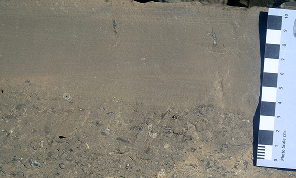
3 Climbing ripples Brodgar stone rotatedA geology moment: This is a side view of one of the Old Red Sandstones, which I’ve rotated horizontal (the image, not the stone!). You can see beautiful climbing ripple laminae.

4 Stenness StonesThe Standing Stones of Stenness may be the oldest such Neolithic structure in Britain. For me it was the most evocative of this ancient and mysterious activity, even if it is the most manicured ring.

5 Stenness StoneThis Stenness stone is one of the most photographed rocks in Orkney.

6 Maes Howe from roadMaes Howe is a Neolithic chambered cairn, possibly built about 2800 BCE. We see here a simple mound across a flat field. The interior is a complex main room with side passages and interior standing stones. This was likely a grave site, but no bones have been discovered in it.

7 Maes Howe closerI wish I could show you the interior, but photography was not allowed. Our party, along with many others, crowded into the chamber after passing through the long and narrow entrance tunnel. Our guide was particularly good at telling the stories of the site and pointing out various archaeological features. On many of the stones are delightful examples of much later Viking runic inscriptions (ancient vandalism, really!).

8 Stabilized beach dunesThe Orkney coastlines have many partially stabilized beach dunes, like these grass-covered examples. Storms, though, can quickly erode them and move vast quantities of sand. Such events have uncovered buried archaeological sites on the shorelines, such as Skara Brae below.

9 Skara BraeSkara Brae is a Neolithic village that was buried for many centuries under such sand dunes. It is now one of the best known archaeological sites in Britain. The sand and sod has been removed from the top of a network of homes and pathways, giving the immediate appearance of World War I trenches.

10 Skara Brae houseThis is one of the homes. It is preserved in remarkably good shape, with all the stone furnishings still in place.

11 Skara Brae mystery stoneThere are many mysterious objects associated with the Skara Brae site, including this fist-sized elaborately carved stone. Any ideas as to its function? Paul Taylor thinks stones like this may have been used for hunting, tied together as bolas.

12 Laird of Skaill captured Bolshevik bannerJust because I find it interesting, here is a banner displayed in the local Laird of Skaill home near Skara Brae, which is open for tours. It is a Bolshevik souvenir captured by one of this blue-blooded family during the North Russia Intervention in Murmansk during the Russian Civil War. History, like geology, is everywhere — and delightfully unpredictable.

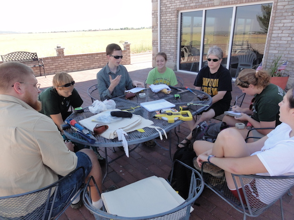
Larwood 2015 participantsFinally, here is a group picture of our 2015 Larwood Symposium participants in Stromness. A most congenial and fun group! Thank you very much to Joanne Porter and Jen Loxton for organizing such a spectacular meeting.


Posted in Uncategorized | Tagged , , , | Leave a comment

Exploring Caithness, Scotland

1 Thurso coast viewTHURSO, SCOTLAND (June 19, 2015) — After meeting in the morning for our 2015 Larwood Symposium, most of the participants then went on a field trip in the region around Thurso in the Caithness district, northern Scotland. Above is a view of the Thurso coast at low tide.

2 Dunnet Head lighthouseOne of the places we visited was Dunnet Head, the most northerly point in mainland Britain. The lighthouse is shown above.

3 Dunnet Head viewThe rocks in this part of Scotland are as austere as the rest of the country. This is the Old Red Sandstone, a Devonian unit found widely in Great Britain. It was deposited under mostly terrestrial conditions, and includes sediments from rivers, lakes, sand dunes and wadis. It splits easily in this part of Scotland into flat slabs called flagstones, which are used for buildings, walls, and tombstones.

4 Dunnet Head flowersThere are beautiful flowers on the windswept slopes of Dunnet Head. If I can, I’ll identify these later and add the name to this post. [Caroline Palmer did us the service: Armeria maritima (Thrift). Thanks, Caroline!]

5 Dunnet Head flowers 2For some reason purple is the most common flower color today. [Caroline identified this as Silene dioica (Red Campion).]

6 Dunnet Head orchidThis is a delicate little orchid I found sheltering behind a wall. [Ah, I made a classic mistake. Caroline points out that this is not an orchid, but a damaged Red Campion (as above). My perspective in this photo gave it a misleading orchid-like appearance. Always a lesson!]

7 John OGroats signJohn O’Groats is the most northeasterly point of mainland Britain. The small village here is 876 miles away from Land’s End in Cornwall, the most southwesterly part of the country. Apparently this is a big deal.

8 Paul Patrick John OGroatsHere we see a typical activity of bryozoan workers: checking fish traps for encrusting colonies. Paul Taylor is on the left and Patrick Wyse Jackson on the left. Paul looks superficially well-dressed, but he’s wearing Crocs on his feet.

9 Old Man of Hoy 2In the evening our party boarded a NorthLink ferry and sailed to Stromness. On the way we passed a sea stack known as the Old Man of Hoy. This erosional feature appeared some time after 1750, and like all coastal rock formations, it is destined to fall into the relentless waves.

10 Stromness from hotel windowFinally in the late evening we made it to the harbor in Stromness, Orkney. This is the view from my window in the Stromness Hotel. The white and blue ferry can be seen in the upper left. We settled in for the night to resume our meeting in the morning.

Posted in Uncategorized | Tagged , , , | Leave a comment

Wooster’s Fossil of the Week: An undescribed cyclostome bryozoan from the Upper Ordovician of Oklahoma

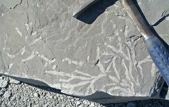
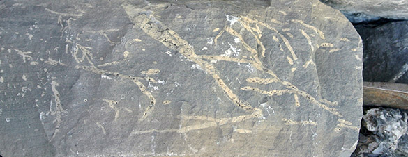
HT_1276 585Paul Taylor and I presented a talk this month at the Larwood Symposium of the International Bryozoology Association in Thurso, Scotland. (Yes, way in the tippy-top of Scotland. Very cool.) Paul found the above wiggly bryozoan encrusting the interior of an orthid brachiopod identified as Multicostella sulcata (thanks, Alycia Stigall!) in the Lower Echinoderm Zone of the Mountain Lake Member of the Bromide Formation (Upper Ordovician, Sandbian) near Fittstown, Oklahoma. This bryozoan is “new to science”, as we grandly say. Paul generously invited me to describe it with him in this presentation and in a future paper. We did a 1994 paper together on Corynotrypa, a similar cyclostome bryozoan. The following are a few slides from our Larwood talk.

Slide01_052815

Slide05_052815

Slide08_052815

Slide15_052815

Slide17_052815

Slide21_052815This last image showing what appear to be an interior wall with a pore is critical. Corynotrypa does not have such walls, so our bryozoan is more like a sagenellid cyclostome.

References:

Carlucci, J.R., Westrop, S.R., Brett, C.E. and Burkhalter, R. 2014. Facies architecture and sequence stratigraphy of the Ordovician Bromide Formation (Oklahoma): a new perspective on a mixed carbonate-siliciclastic ramp. Facies 60: 987-1012.

Taylor, P.D. and Wilson, M.A. 1994. Corynotrypa from the Ordovician of North America: colony growth in a primitive stenolaemate bryozoan. Journal of Paleontology 68: 241-257.

Posted in Uncategorized | Tagged , , , | 1 Comment

Wooster Geologist in Scotland

1 Thurso streetTHURSO, SCOTLAND (June 18, 2015) — My long train trip from Scarborough was successful yesterday. I arrived in the dark (or what passes for darkness this far north) and had a long walk from the train station to my hotel. My introduction to Scotland was a driving rain with high winds, so I arrived at the hotel soaked through. These photos, then, are from this morning with much better weather.

2 Thurso seaview 061815This is the very Scottish view from my hotel into the North Sea. The ferry to Orkney departs from the small harbor of Scrabster to the left.

3 Weigh Inn ThursoHere is my hotel. Last night I found it on the outskirts of this small city in a rainstorm.

We had our first sessions of the 2015 Larwood Symposium today at the Environmental Research Institute in Thurso. I was very pleased to give my talk in the morning so I can relax for the rest of the meeting.

Posted in Uncategorized | Tagged , | Leave a comment

On the rails heading north. Way north.

Scarborough station 061715SCARBOROUGH, ENGLAND (June 17) — It is my turn to leave Scarborough. Mae and Meredith went south to London and then on to Paris yesterday. I’m heading north today into Scotland for a Larwood Symposium (run by the International Bryozoology Association) in Thurso and later Stromness.

Screen Shot 2015-06-24 at 8.36.16 PMThe trip is nearly 12 hours long by train, with connections in York, Edinburgh, and Inverness. I’m getting good use out of my BritRail Pass. I hope to see much through my windows as we cross through Lowland Scotland into the Highlands and eventually the north coast. Thurso is the most northerly station in the British rail system.

Scarborough benchDid you know the world’s longest bench is in the Scarborough Rail Station?

Posted in Uncategorized | Tagged , , | 1 Comment

Travel days

1 Mae Meredith waiting 061615SCARBOROUGH, ENGLAND (June 16, 2015) — Team Yorkshire split up this morning. Mae Kemsley (’16) and Meredith Mann (’16) packed up very efficiently and took a train to London via York. There plan is to see some London sights and then take a night train to Paris, where they will spend a few days.

2 Mae Meredith on train 061615It is always a sweet time to see healthy and happy students at the end of the fieldwork heading off on their own adventures. Bittersweet, though, because we had such a great time and I have one more day in Scarborough.

3 Scarborough station 061615This is the small Scarborough train station. A set of tracks ends here, so there is only one way in and out.

4 Train to York 061615The train that took Mae and Meredith out of Scarborough. I will be on the same train tomorrow as I start a 14-hour journey to Thurso, Scotland, via York, Edinburgh and Inverness.

5 Scarborough Westborough StreetFor the rest of my lonely day, I explored Scarborough. This is Westborough Street with its modern shops and restaurants. Team Yorkshire ate a lot of fish and chips in this neighborhood.

6 Scarborough view 061615Merchants Street is an older part of Scarborough. You can see the walls of Scarborough Castle on the skyline.

7 Grand Hotel 585 061615Finally, one last view of the Grand Hotel, a Victorian building that has a long history, including being shelled by the Germans in 1914. Our hotel was across the street and far less fancy. This afternoon I sat in its lobby and read a book to escape the cold and clammy weather that descended on the city.

Posted in Uncategorized | Tagged , , , | Leave a comment

Team Yorkshire finishes its fieldwork

1 Speeton Clay at Reighton Sands 061515SCARBOROUGH, ENGLAND (June 15, 2015) — It is difficult to believe that yesterday was so cold and wet. Today was beautiful on the Yorkshire Coast. Mae Kemsley (’16), Meredith Mann (’16) and I traveled to Reighton Sands for one last look through Mae’s outcrops. The tide was very low and the sunshine abundant, so we took lots of images and collected another bag of fossils. Above is the Speeton Clay (Lower Cretaceous). It rarely looks so good in photographs.

2 Morning commute 061515A scene from our morning commute from Scarborough. We like sitting in the top front of the double-decker bus.

3 SS Laura boilersThe tide was low enough to expose the pair of boilers from the SS Laura. You may recall this Austro-Hungarian cargo ship ran aground here on November 21, 1897. These heavy and resistant boilers have served as coastal landmarks for over a century.

4 Mussels Barnacles on boilersThe SS Laura boilers are also a significant hard substrate for attaching mussels and barnacles.

5 Flamborough Head 061515The white chalk cliffs of northern Flamborough Head were especially beautiful today. I wish there was a way to record the sounds of thousands of circling seabirds.

6 Red Chalk outcrop 061515We visited an outcrop of the Red Chalk (Hunstanton Formation, Lower-Upper Cretaceous) one last tme to collect more belemnites for Mae’s future analytical work.

7 Red Chalk fossils 061515We found quite a few Neohibolites, along with a coiled serpulid or two.

8 Speeton belemnites in placeThen it was back to the gray Speeton Clay. After yesterday’s rain, the belemnites seemed very easy to find. Today we were after belemnites that had borings and/or encrusters.

9 Mae Meredith frisbee SpeetonMae and Meredith took advantage of the beach to toss a frisbee around. They are both members of Wooster’s superb Ultimate Frisbee team.

10 Speeton sand patterns IIWe walked the long arc of Filey Bay to Filey. I was fascinated with the patterns in the sand left by the receding tide.

11 Speeton sand patterns IThose same sand patterns with a stone producing interference.

12 Filey 061515The seaside portion of Filey, viewed from the south.

13 Last view of Filey BriggAnd finally a view of Filey Brigg from Filey. We were very pleased to have our last field day such a pleasant one. We hope we’ve prepared the way for future Wooster Independent Study projects in this beautiful part of the world.

Posted in Uncategorized | Tagged , , , , , | Leave a comment

Last day of fieldwork on Filey Brigg in Yorkshire

1 Mae Meredith Passage Beds 061415SCARBOROUGH, ENGLAND (June 14, 2015) — It was a drizzly, breezy, cold day on the outcrops, but Team Yorkshire finished measuring and collecting for Meredith Mann’s project on the Passage Beds Member of the Coralline Oolite Formation (Upper Jurassic, Oxfordian) exposed on the north side of Filey Brigg, a spit of rock between Scarborough and Filey. In the posed but useful image above, Meredith stands at the base of the Passage Beds, and Mae holds a meter stick pointing to the top, with the cross-bar on the Thalassinoides unit at the base of the Hambleton Oolite.

2 Annotated Passage Beds 061415We designated five subsidiary units within the Passage Beds, as shown above. The rocks below belong to the Saintoft Member of the Lower Calcareous Grit Formation; the rocks above are the Hambleton Oolite (Lower Leaf) Member of the Coralline Oolite. Note how more ragged this exposure is because it directly faces the sea. The erosion better exposes the stratigraphy and fossils. It also means when we work here we are more subject to the elements.

3 Low tide access Filey BriggThis location on the north side of Filey Brigg is only accessible at low tide across slick algal-encrusted rocks. The angry sea looms to the right.

4 Bouldery walkWe have to climb over these boulders which are piled against a cliff face.

5 High tide escape ladderSince this area is flooded at high tide, if you wait too long to hike back the only escape from the raging North Sea is up this emergency ladder. I kept my eye on the ocean behind us!

6 Splashy Filey Brigg 061415The remorseless sea pounding away at Filey Brigg during a rising tide. I hate rising tides.

7 Mae Meredith working 061415Meredith and Mae at work collecting rock samples and fossils. We are somewhat protected here from the rain by the overhanging Hambleton Oolite. The wind still blew in plenty of water from sea and sky.

8 Thalassinoides in Unit 1An alcove in Unit 1 of the Passage Beds with galleries of the trace fossil Thalassinoides.

9 Crossbedding Unit 3Unit 3 of the Passage Beds shows cross-bedding, which is consistent with its origin as sediments washed shoreward during storms.

10 Unit 1 fossils 061415A cluster of oysters and pectinid bivalves in Unit 1 of the Passage Beds.

11 Mae Meredith Filey BriggWe celebrated completion of our fieldwork by walking as far out on Filey Brigg as we could! Miserable weather, but a dramatic setting! And no one broke a leg on the boulders or was trapped by the high tide.

Posted in Uncategorized | Tagged , , , , | Leave a comment

Rain delay in Yorkshire. Time for sample management.

Sample management 061315SCARBOROUGH, ENGLAND (June 13, 2015) — Our good fortune with the weather finally ended with a steady downpour this morning. Since it was during an advantageous tide, and I didn’t want us slipping around on wet intertidal boulders at Filey Brigg, we cancelled the day’s fieldwork. As generations of Wooster paleontologists know, this gives us time for Sample Management. We went through all that we collected, washed each fossil in my bathroom sink, and dried the lot on the hotel towels so kindly provided to us. It was the first time I got a good luck at many of the specimens the students collected, so it was rather fun. We then rebagged and labelled everything for the trip back home. Mae and Meredith have put together a nice collection for their studies. We have two more days of fieldwork to finish collecting for Meredith’s project.

Posted in Uncategorized | Tagged , , , , , | Leave a comment

Battle of Flamborough Head (September 23, 1779)

Flamborough HeadMost of our work as Team Yorkshire this month has been in Filey Bay on the northeastern coast of England. When we look south, as above, we see the northern extent of the famous Cretaceous chalk cliffs that extend far into the south of the country along the Channel coast. This point of chalk that we see jutting into the North Sea is Flamborough Head. If we were here on September 23, 1779, we would have seen here a dramatic naval battle between the Royal Navy and the earliest ships of the Revolutionary United States.

Flamborough Google MapFor orientation, you see Scarborough at the top of this Google map, and then Filey down the coast (with Filey Brigg visible as a thin finger of rock diving into the sea). The top image was taken on the coast at Reighton Gap looking south.

Gilkerson 1In these waters on that September day, Commodore John Paul Jones in the USS Bonhomme Richard (on the right) met Captain Richard Pearson of the HMS Serapis. The painting is by William Gilkerson and is displayed in the US Naval Academy Museum. The battle was a complicated bit of seamanship on both sides, and both sides could claim victory. Overall, though, it was an astounding feat of American arms to have engaged the world’s largest and effective navy in its home waters. The story of the battle is best told by J. Scott Harmon on this website.

Battle map FlamboroughThe initial engagement of the HMS Serapis and USS Bonhomme Richard north of Flamborough Head. (From the US Naval Academy. Go there for a nice set of map animations.)

Richard Willis paintingThis part of the world has seen much dramatic military history, from the Romans to the Germans. We find this battle particularly moving because of the role of the new United States asserting its independence. (Painting by Richard Willis.)

Posted in Uncategorized | Tagged , , , | Leave a comment