About a month ago, I wrote on this blog about an exceptionally dry late summer for Wooster. It was dry enough to put much of northeast Ohio in a moderate drought. But of course the moment I published that blog post, it started to rain… and historically so. Using the Wooster Experimental Station data going back to 1900, Wooster has gone from one of the driest August-September periods to one of the wettest October-early Novembers. The average precipitation in Wooster for Oct 3 through Nov 7 is 2.99″. This year, we had 6.91″, more than double the average and ranking third highest ever (0.46″ lower than the record from 1954).*
So this brings us to two important questions: 1) Did this kick the drought? and 2) Why did this happen?

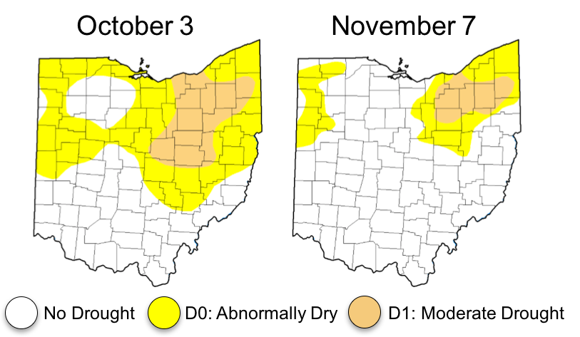
Figure 1. Change in drought levels for Ohio from October 3 to November 7. Data from US Drought Monitor. Wayne County is all still abnormally dry or in moderate drought, but the dryness has waned considerably.
To answer the first question: almost, but not quite. Figure 1 shows the change in drought levels from October 3 to November 7. The area of Ohio experiencing drought shrunk from 11% to 6% of the state, although half of Wayne County is still “in the beige”. Areas experiencing either “dryness” or “drought” shrunk from 40% to 22% of the state. The rate of evapotranspiration is also at play here, but the change in rain fortunes has likely been the main driver in alleviating the dry spell.
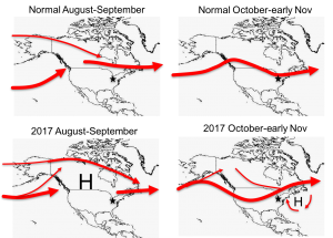
That second question — why did we oscillate from very dry to very wet? — has a coy answer and a serious answer. Coy answer: The weather is fickle. Serious answer: It’s all about the polar jet stream. The polar jet stream is a narrow band of strong westerly winds that sits up roughly 10 km (6 mi) above sea level. Especially in winter, this jet stream is main conveyor belt of storms that affect Ohio. In a typical August and September, it usually sits a bit north of us, just north of the US-Canada border (Figure 2, upper-left), occasionally giving Ohio rain. This year (lower left), the main jet stream path was much farther north than normal, just grazing the Canadian Arctic Archipelago. It was a non-factor this summer for Ohio. This abnormal ridge was also associated with a large high pressure area over most of North America. High pressure typically means calmer, warmer summer weather — and that is precisely what we had in the Midwest. These two features — the ridge in the jet stream and the high pressure at the surface — reinforced each other to create the dry conditions in late summer.

Figure 2. Comparing jet stream patterns and “blocking highs” from August to mid-November 2017 to normal. The star (roughly) indicates Wooster Ohio. Stylized from NCEP-NCAR Reanalysis.
But since about October 3, the jet stream pattern has shifted. A normal October has the jet stream shift southward a little anyway (Figure 2, upper right), but this year it pushed much farther south than normal over the western half of the country (lower right). This put Ohio in a prime position to receive more storms than normal — just downwind of a big trough in the jet stream. Related to this, a smaller blocking high set up off the coast of New England and Nova Scotia, which helped direct warm, wet Atlantic air over the Appalachians and toward Wooster. The best example of the results came from the November 5 storm, when nearly 2″ of rain was accompanied by tornado warnings across several Ohio counties.
*Footnote: The start and end dates of October 3 and November 7 are rather arbitrary, but 2017 still ranks in the top ten rainiest years out of 117 even if you add or subtract a few days — so long as you include the big rain storm from November 5.
References:
Mason, John (2013 May 20). “A Rough Guide to the Jet Stream”. Skeptical Science. Retrieved 13 Nov 2017. https://skepticalscience.com/jetstream-guide.html
Kalnay, E. and Coauthors (1996). The NCEP/NCAR Reanalysis 40-year Project. Bull. Amer. Meteor. Soc., 77, 437-471. https://www.esrl.noaa.gov/psd/data/composites/day/
United States Drought Monitor. The National Drought Mitigation Center. Retrieved 13 Nov 2017. http://droughtmonitor.unl.edu/Maps/CompareTwoWeeks.aspx
Wooster Experimental Station at Climate Data Online (1900 – 2017). NOAA. Retrieved 13 Nov 2017. https://www.ncdc.noaa.gov/cdo-web/datasets/GHCND/stations/GHCND:USC00339312/detail


Nice post–thank you! A good discussion to add to this is that of the Arctic and North Atlantic Oscillations, and how the loss of Arctic sea ice has led to a deterioration in the boundary between the Polar and Ferrel atmospheric circulation cells, which then led to a less-predictable, and wobbly, Polar Jet, with the ignominious “polar vortex” and the “omega block” that popular (commercial) meteorologists have latched onto, but never really explain to the lay audience. That was a long sentence, sorry…. What’s really interesting, however, is the interplay between El Niño/La Niña/La Nada, the Arctic and North Atlantic Oscillations, and other, perhaps still unknown, mega-scale, atmospheric phenomena, which all conspire to make our weather much more unpredictable, and potentially severe, than it “used to be,” in our short, human, perspective. The upper Midwest does, however, seem to maintain its “sweet-spot” from a climatologic perspective, since we’re at the intersection between cold-dry and warm-wet mega-circulation, i.e., a potentially good place to avoid the worst of climate change. And, just to show you how fickle our local weather can be, my rain gauge shows 52.64 inches for the year (not including our feeble snowfall), which is just about off the charts.
Hi Bill, thanks for the comment! I appreciate that optimism about the Midwest. From my readings, the Midwest is rarely highlighted as a place likely to be hit hard by climate change, but I’ve never bothered to dig into the “why”.
It’s interesting that you point out the relationship between sea ice loss and atmospheric circulation. That’s a good point. This summer-fall is the sort of thing that proponents of the idea would point to as a good example of the phenomenon. However, from a conference I was at earlier this year, there is much contention amongst atmospheric scientists regarding how important the loss of sea ice is compared to other changes (chiefly warming of the upper troposphere in the tropics and changes to ocean circulation). The rub seems to be that all of these aspects are interconnected, we don’t have enough data to capture those longer-scale oscillations, and our climate models don’t provide adequate depictions of the oceans (yet) to disentangle everything via numerical experiments.