Wooster Geologists tramping through the brush of southern Minnesota

1 Shop Quarry 072816Rochester, Minnesota — The middle of the summer is not the best time to do fieldwork in southern Minnesota. The thick and diverse plants make each journey to an abandoned quarry wall or roadcut a jungly adventure. It doesn’t help that some plants, like poison ivy and the abundant wild parsnip, are, shall we say, unfriendly. Ticks, so far, have been uncommon. I nevertheless go to sleep wondering if there is a tick somewhere I haven’t found, and whether that itchy spot means anything …

Today was our last day with our expert guide from the Minnesota Geological Survey (and Wooster Geology alumnus) Andrew Retzler. We visited three locations where the Decorah Formation is exposed. The top image is us on an abandoned slope of a quarry near Rochester.

2 Andrew Retzler Shop QuarryAndrew is enjoying the many fossils in the Decorah at this site. Note the thin carbonate slabs that weather out of the shale.

3 Turkey Run viewTurkey Run was our second site of the day. The Decorah and lower part of the Cummingsville Formation are exposed here. We needed a machete!

4 Turkey Run 072816The students are examining the Decorah shales on the left. Andrew is on the right with his hand on the base of the Cummingsville Formation.

5 Wangs Corner 072816Wang’s Corner was our third and last stop of the day. This exposure of the Decorah was right on the side of the road, making it the easiest outcrop yet. While we worked, Nick Wiesenberg on the left made us delicious salmon and cheese cracker snacks. That was a new field trip experience for me: fine dining while collecting!

6 Team Minnesota 072816Here we are in Hernke’s Rock Quarry with the Shakopee Formation, part of the Prairie du Chien Group (Early Ordovician).

All is thus well with Team Minnesota as Andrew Retzler leaves us and we’re on our own. We have four student projects we’ll outline here over the next few days. The temperatures dropped as a front moved through, so we had a cool, drizzly day. Tomorrow we return to Iowa.


Posted in Uncategorized | Tagged , | Leave a comment

Team Minnesota visits the Upper Ordovician of Iowa

1 Decorah Bruening QuarryRochester, Minnesota — Team Minnesota traveled south today to visit exposures of our three favorite formations: the Platteville Limestone, Decorah Shale, and Cummingsville Limestone. Where best to see the Decorah Shale than in Decorah, Iowa? Above the crew is scattered in the abandoned Decorah Bruening Quarry. They are walkinng on top of the Carimona Member of the Decorah, with the shaley units above topped by the Cummingsville Limestone.

2 Team with Deicke at Decorah BrueningWe began at the bottom with the Platteville and a bit of rare shade. Nikki Bell and Etienne Fang have their hands on the iconic Deicke Bentonite. A very handy time indicator, that volcanic ash deposit.

3 Andrew Decorah Cummingsville contactOur excellent guide Andrew Retzler of the Minnesota Geological Survey is examining the contact between the upper Decorah Shale and Lower Cummingsville Limestone. We found here several specimens of the “gumdrop” bryozoan Prasopora.

4 Rachel CummingsvilleRachel Wetzel gets a bit too close to the crumbly cliff of Cummingsville Limestone at the Decorah Bruening  Quarry.

5 Cummingsville limestoneWhere freshly exposed, the Cummingsville reveals itself to be a fascinating unit with alternating limestone lithologies. The darker layer here is a packstone with fine fossil debris. It is almost certainly a storm deposit.

6 Cummingsville ChondritesThis slab of Cummingsville is covered with beautiful Chondrites trace fossils.

7 Team at Golden HillIn the afternoon we returned to Minnesota and explored a very overgrown exposure of the Decorah Shale at the Golden Hill abandoned quarry along US 52 near Rochester. The main attraction here for us is the abundance of “iron ooids”, small spheres of iron oxides. Etienne Fang is studying their composition and origin for her Independent Study thesis. It’s a steep and muddy slope after a journey through head-high brush, but the bags full of samples made it worthwhile.

8 Golden Hill slabThe fossils here are gorgeous. This is the base of a crinoid calyx surrounded by brachiopod, crinoid and bryozoan debris.

It was a great day of exploration. Tomorrow we examine localities north of Rochester.

Posted in Uncategorized | Tagged , , , , | Leave a comment

Team Minnesota Assembles!

1 Team MN 0772616Rochester, Minnesota — The first Team Minnesota of Wooster Geologists has now gathered for its work in this beautiful state. Above from the left is Rachel Wetzel (’17), Dean Thomas (’17), Nick Wiesenberg (Geological Technician), Nikki Bell (’17) and Etienne Fang (’17). They’ve gathered from five states to pursue integrated Independent Study fieldwork in the Upper Ordovician Decorah Formation and related units. AS you can see, our first day was bright and warm. The team is in front of the headquarters of the Minnesota Geological Survey in St. Paul. It is a very earnest, hardworking place.

2 Platteville Decorah Mississippi GorgeAfter sorting out car rentals, airport arrivals, and our first lunch, we met four geologists from the Minnesota Geological Survey (MGS) and drove to an outcrop a few miles south in St. Paul along the east bank of the Mississippi River. We are looking here at the group exploring the upper portion of the Platteville Limestone and the lower part of the Decorah Shale.

3 All star castThose four geologists from the MGS are an all-star team. They included Tony Ruckel (Chief Geologist and Paleozoic Geologist), Julia Steenberg (Paleozoic Geologist), Jenn Horton (Quaternary Geologist and a Wooster Geology alumna), and Andrew Retzler (Paleozoic Geologist and another Wooster Geology alum). What a great scientific start. We learned much in just a few hours from their experiences with the Decorah Shale and associated units. Andrew will be our guide to the outcrops over the next couple of days.

4 Team MN at work 072616Examining the top of the Platteville Limestone at the Mississippi River Gorge Park site.

5 Dean Deicke Carimona aboveDean’s left hand is in a crevice where the famous Deicke Bentonite is exposed. This is a layer of altered volcanic ash from massive eruptions to the east associated with the Taconic Orogeny. These widespread ash layers make superb time lines in the rock record. Unfortunately we can’t see the actual clay because it was mined out by visiting geologists!

6 Mississippi River 072616The Mississippi River at our first outcrop. The rocks are Platteville Limestone. The Marshall Avenue Bridge is in the background.

7 Minnehaha FallsThe last stop on this brief first day tour was Minnehaha Falls. The rocks exposed are, from the base, the St. Peter Sandstone, the Glenwood Shale, and the Platteville Limestone.

After a delicious dinner in an outdoor restaurant in Minnehaha Park, we drove down to Rochester, which is our base of operations. We enjoyed meeting new friends and getting our first look at the rocks. Tomorrow we begin a systematic survey of the Decorah outcrops in southeastern Minnesota and northern Iowa.

Posted in Uncategorized | Tagged , | Leave a comment

Keck GSA Abstracts

Wooster, OH – The summer portion of the Keck Iceland project is officially over, but our research isn’t finished. We’ll be working together throughout the academic year and will synthesize our final results at the Keck Symposium at Wesleyan University in April 2017. Along the way, we’ll be presenting at GSA in Denver, Colorado. We wrote and submitted 4(!) abstracts based on our work this summer. Here they are:

Cara Lembo ('17, Amherst) stands next to a ridge-parallel dike intruding through a tephra cone. Helgafell, a hyalocastite edifice, is in the distance.

Cara Lembo (’17, Amherst) stands next to a ridge-parallel dike intruding through a tephra cone. Helgafell, a hyalocastite edifice, is in the distance.

NEW INSIGHTS ON THE FORMATION OF GLACIOVOLCANIC TINDAR RIDGES FROM DETAILED MAPPING OF UNDIRHLIDAR RIDGE, SW ICELAND

HEINEMAN, Rachel1, LEMBO, Cara2, ENGEN, Carl-Lars3, KOCHTITZKY, William4, WALLACE, Chloe5, ORDEN, Michelle4, THOMPSON, Anna C6, KUMPF, Benjamin5, EDWARDS, Benjamin R.4 and POLLOCK, Meagen5, (1)Department of Geology, Oberlin College, 52 West Lorain St, Oberlin, OH 44074, (2)Department of Geology, Amherst College, 11 Barrett Hill Dr, Amherst, MA 01002, (3)Department of Geology, Beloit College, 700 College Street, Box 777, Beloit, WI 53511, (4)Department of Earth Sciences, Dickinson College, 28 N. College Street, Carlisle, PA 17013, (5)Department of Geology, The College of Wooster, 944 College Mall, Wooster, OH 44691, (6)Department of Geology, Carleton College, One North College Street, Northfield, MN 55057, rheinema@oberlin.edu

Undirhlíðar ridge on the Reykjanes Peninsula in southwest Iceland is a glaciovolcanic tindar formed by fissure eruptions under ice. Previous work in two quarries along the ridge shows that this specific tindar has had a complex eruption history. Here we report new results from investigations along the length of the ridge (~3 km) between the quarries. We have identified aerially significant fragmental deposits and a potential vent area on the ridge’s eastern side. The newly mapped tephra deposits are dominated by lapilli- and ash-size grains that are palagonitized to some degree (~20-60%) but locally contain up to ~75% fresh glass. Basal units are tuff breccia to volcanic breccia with basaltic and rare gabbroic lithic clasts. Upper units are finely bedded with few large clasts and some glassy bombs. Locally, lapilli-tuff units show repetitive normally graded bedding and cross bedding. Measured bedding attitudes suggest that present exposures represent a moderately eroded tephra cone that was subsequently intruded by basaltic dikes. Extending north and south of the tephra cone, the upper surface of the ridge comprises pillow rubble with outcrops of massive basalts showing radial jointing and concentric vesicle patterns. All of the outcrops appear to be similar coarse-grained, olivine- and plagioclase-bearing basalts; ongoing petrographic and geochemical analysis will determine if the bodies represent “megapillows” or if they are related to intrusions that are present in both quarries. Along the western side of the ridge, lapilli tuff and/or volcaniclastic diamictites overlie pillow lava (or volcanic breccia made of pillow fragments) that is locally intruded by dikes. In northern gullies, at least two stratigraphically distinct units of pillow lava are present. In order to communicate the implications of our detailed research to a broad audience, we are constructing two “map tours” of the ridge: one that is centered on the abandoned and accessible Undirhlíðar quarry, and another that describes features along the upper part of the ridge between the quarries. Stops along the tour include exposures of dikes, pillow lavas, and erosional alcoves within the tephra cone. The goal of these tours is to compare similar units across the ridge and quarry and to show the general anatomy of a glaciovolcanic ridge.

Rachel Heineman ('17, Oberlin) stands next to a potential "megapillow."

Rachel Heineman (’17, Oberlin) stands next to a potential “megapillow.”

Cross section of a pillow lava, with Michelle Orden's ('17, Dickinson) head for scale.

Cross section of a pillow lava, with Michelle Orden’s (’17, Dickinson) head for scale.

PHYSICAL CHARACTERISTICS OF GLACIOVOLCANIC PILLOW LAVAS FROM UNDIRHLIDAR, SW ICELAND

THOMPSON, Anna C1, ORDEN, Michelle2, LEMBO, Cara3, WALLACE, Chloe4, KUMPF, Benjamin4, HEINEMAN, Rachel5, ENGEN, Carl-Lars6, EDWARDS, Ben2, POLLOCK, Meagen4 and KOCHTITZKY, William2, (1)Department of Geology, Carleton College, One North College Street, Northfield, MN 55057, (2)Department of Earth Sciences, Dickinson College, 28 N. College Street, Carlisle, PA 17013, (3)Department of Geology, Amherst College, 11 Barrett Hill Dr, Amherst, MA 01002, (4)Department of Geology, The College of Wooster, 944 College Mall, Wooster, OH 44691, (5)Department of Geology, Oberlin College, 52 West Lorain St, Oberlin, OH 44074, (6)Department of Geology, Beloit College, 700 College Street, Box 777, Beloit, WI 53511, thompsona@carleton.edu

Pillow lavas are one of the most abundant lava morphologies on Earth, but are relatively inaccessible because of their submarine or subglacial eruption environments. Our research location in a former rock quarry in southwest Iceland provides a unique opportunity to view cross-sections through well exposed pillow lavas on land. The quarry is located at the northern end of Undirhlíðar, which is a glaciovolcanic ridge on the Krisuvik fissure system, and exposes thousands of individual pillow lavas. This study uses detailed field and laboratory observations of vesicle distributions and jointing patterns to better constrain the mechanisms that control vesiculation, bubble transport, and cooling rates during emplacement of pillow lava. From detailed analysis of >40 exposed pillow cross sections, we have identified 7 fracture characteristics that make up a combination of fracture patterns within the pillow lavas. These characteristics include: short (<5 cm) fractures at the outer edge of a pillow, fractures within pillow cores, fractures between the core and the edge of a pillow, long fractures (up to 40 cm) that go through the entire pillow, ‘web’-like fractures, fractures that branch from other fractures, and curvilinear fractures that cut through bands of vesicles. The distributions of vesicles are more diverse, with at least 12 different patterns defined by characteristics including: concentric banding, moderately/highly vesicular cores, non-vesicular cores, and open cavities. We identified 6 vesicle pattern combinations in the field, and are using image analysis of nearly 50 field photographs to characterize the patterns. These characteristics will constrain physical modeling to better understand how variations in emplacement conditions (abrupt pressure changes, lava discharge rates, water infiltration along fractures) are recorded by the lavas. These pillow lavas are the only lasting record of a preexisting englacial lake presumably formed during the eruption of the lavas, so understanding the details of their textures may provide new insights into the hydrology of the enclosing ice (occurrence of syn-eruption jokulhlaups, efficiency of sub-ice drainage).
Chloe Wallace ('17, Wooster) samples glassy pillow lava rinds for geochemical analysis by XRF and FTIR.

Chloe Wallace (’17, Wooster) samples glassy pillow lava rinds for geochemical analysis by XRF and FTIR.

GEOCHEMICAL CONSTRAINTS ON THE MAGMATIC SYSTEM AND ERUPTIVE ENVIRONMENT OF A GLACIOVOLCANIC TINDAR RIDGE FROM UNDIRHLíðAR, SW ICELAND

WALLACE, Chloe1, KUMPF, Benjamin1, HEINEMAN, Rachel2, LEMBO, Cara3, ORDEN, Michelle4, THOMPSON, Anna C5, ENGEN, Carl-Lars6, KOCHTITZKY, William4, POLLOCK, Meagen1, EDWARDS, Ben4and HIATT, Alex1, (1)Department of Geology, The College of Wooster, 944 College Mall, Wooster, OH 44691, (2)Department of Geology, Oberlin College, 52 West Lorain St, Oberlin, OH 44074, (3)Department of Geology, Amherst College, 11 Barrett Hill Drive, Amherst, MA 01002, (4)Department of Earth Sciences, Dickinson College, 28 N. College Street, Carlisle, PA 17013, (5)Department of Geology, Carleton College, One North College Street, Northfield, MN 55057, (6)Department of Geology, Beloit College, 700 College Street, Box 777, Beloit, WI 53511, cwallace17@wooster.edu

Glaciovolcanic tindar ridges are landforms created by the eruption of magma through fissure swarms into ice. The cores of many of these ridges comprise basaltic pillow lava, so they serve an accessible analogue for effusive mid-oceanic ridge volcanism. Furthermore, similar landforms have been identified on Mars, and thus they may also serve as models for planetary volcanic eruptions. To better understand pillow formation and effusive glaciovolcanic eruptions, we are investigating Undirhlíðar ridge, a pillow-dominated tindar on the Reykjanes Peninsula in southwest Iceland. Our detailed mapping and sampling in two rock quarries along the ridge and in the ~3 km area between the quarries show that this specific tindar ridge has had a complex eruption history. In the northern quarry (Undirhlíðar), Pollock et al. (2014) demonstrated that at least two geochemically distinct magma batches have erupted. Further trace element and isotope analyses in the southern quarry (Vatnsskarð) suggest that the ridge is fed by a heterogeneous mantle source. Isotopic Pb data show a spatially systematic linear array, which is consistent with a heterogeneous mantle mixing between depleted and enriched endmembers. The occurrence of multiple magma batches in dikes and irregular intrusions suggests that these structures are important to transporting magma within the volcanic edifice. Glassy pillow rinds were sampled for volatile analysis by FTIR in order to determine how paleo-water pressures vary along the ridge. In Undirhlíðar quarry, paleo-water pressures decrease with stratigraphic height (1.6-0.7 MPa). In Vatnsskarð quarry, paleo-water pressures show evidence of two separate eruptions, where pressure values decrease with an increase in stratigraphic height from 1.1 to 0.7 MPa over ~30 m, at which point pressure resets to 1.1 MPa and continues to decrease with elevation. When comparing the two quarries, paleo-water pressures in the upper units of Undirhlíðar and all the units in Vatnsskarð have similar values (0.7-1.1 MPa), and these are lower than the basal units of Undirhlíðar (1.2-1.6 MPa). Overall, compositional variations correlate with stratigraphy and spatial distribution along axis, suggesting that glaciovolcanic eruptions and their resulting landforms show a higher level of complexity than previously thought.

A view looking NE into Undirhlidar quarry on a moody Icelandic day. (Photo Credit: Ben Edwards)

A view looking NE into Undirhlidar quarry on a moody Icelandic day. (Photo Credit: Ben Edwards)

3-D

MAPPING OF QUARRY WALLS TO CONSTRAIN THE INTERNAL STRUCTURE OF A GLACIOVOLCANIC TINDAR, SW ICELAND

EDWARDS, Benjamin R.1, POLLOCK, Meagen2, KOCHTITZKY, William1 and ENGEN, Carl-Lars3, (1)Department of Earth Sciences, Dickinson College, 28 N. College Street, Carlisle, PA 17013, (2)Department of Geology, The College of Wooster, 944 College Mall, Wooster, OH 44691, (3)Department of Geology, Beloit College, 700 College Street, Box 777, Beloit, WI 53511, edwardsb@dickinson.edu

Documentation of the internal structures of volcanoes are critical for understanding how edifices are built over time, especially for glaciovolcanoes, which have rarely formed historically and are inaccessible during eruptions. We have been unraveling the internal structure of a complex glaciovolcanic ridge (tindar) in southwestern Iceland for the past 5 years in order to better understand the sequence of events that built the ridge. Undirhlidar ridge is ~5 km long, and has been dissected by two different aggregate mines along its axis. The northern mine (Undirhlidar quarry) is inactive and has walls up to 40 m in height that fully expose several critical stratigraphic relationships including multiple sequences of separate pillow lava flows, cross-cutting dikes that locally feed overlying pillow flows, and ridge parallel, continuous massive jointed basaltic units that may be the remnants of internal lava supply networks. The second quarry, ~3 km to the southwest (Vatnsskard quarry) is presently active and continually has new exposures. This quarry only penetrates halfway through the width of the ridge but has ~500 m of exposure along strike. It also has remnants of what appears to be the internal magma distributary system, and many components clearly show evidence that they were (and some still are) open lava tubes. While both quarries contain excellent exposures, many of the structures are difficult to safely access or are inaccessible due to mining activity. In order to overcome access issues, we have used Structure-from-Motion techniques to make 3-D maps of the quarry walls. A series of overlapping pictures were taken from points constrained with D-GPS using a Trimble GeoXH data logger and external antennae. The image locations with corrected positions were imported into Photoscan software to create a point cloud representative for each quarry and to derive a Digital Elevation Model with a reported vertical resolution of less than 1 m. Field testing of a preliminary, low resolution DEM shows that measurements of dyke widths on the DEM have errors of ~5% relative to measurements on the ground. Measurements made from the field-generated DEM will provide significantly better constraints on deposit thicknesses and volume estimates compared to traditional methods of estimating unit thicknesses on vertical faces.

Posted in Uncategorized | Tagged , , , , , , , , | Leave a comment

Wooster’s Fossil of the Week: A bored rhynchonellid brachiopod from the Middle Jurassic of France

1 Kutchi dorsal 585Another beautiful brachiopod this week from our friend Mr. Clive Champion in England. His donations to our collections have considerably enriched our teaching program, especially for brachiopods! This specimen is the rhynchonellid Kutchirhynchia morieri (Davidson, 1852) from the Middle Jurassic (Upper Bathonian) of Luc-sur-Mer, France. This is a view of the dorsal side with the dorsal valve on top with the ventral valve (containing the round opening from which the stalk-like pedicle extended) seen below it. Like most rhynchonellids, the valves have distinct plicae (thick ridges) where the shell is tightly folded.
2 Kutchi ventral 585This is the ventral view showing only the exterior of the ventral valve. Note the curved serpulid worm tube attached near the center, and the squiggly borings. These were likely sclerobionts (hard substrate dwellers) that occupied the brachiopod shell when the animal was still alive, since the dorsal and ventral valves are still articulated. The borings are probably of the ichnogenus Talpina, but I would have to grind down the shell to know for certain.
SSBuckmanThe genus Kutchirhynchia was named by Sydney Savory Buckman (1860-1929) in 1917. We met Buckman earlier in this blog when looking at another of his Jurassic rhynchonellid genera, Burmirhynchia. We learned a lot more about Buckman this summer during our expedition to the Jurassic of Dorset, where he did much of his work. He is best known there as an ammonite worker and stratigrapher (and massive taxonomic splitter).
3 Thomas DavidsonThe species Kutchirhynchia morieri was named by the Scottish paleontologist Thomas Davidson (1817-1885), who originally placed it in the large genus Rhynchonella. Buckman acknowledges Davidson in an ammonite monographs as one of his “earliest geological friends”. (Davidson was 43 years older than Buckman.) Davidson was born in Edinburgh to wealthy parents. He studied at the University of Edinburgh and then in France, Italy and Switzerland, where he made many long geological tours. He was convinced by the German paleontologist Christian Leopold von Buch (1774-1853) to work on fossil brachiopods. (Von Buch was 43 years older than Davidson. Nice to see the older generation having an effect on those kids!) Davidson stayed with brachiopods his entire career, producing massive monographs on both fossil and recent forms. He engraved his own plates on stone, and there are more than 200 of them. Davidson was elected a fellow of the Geological Society of London in 1852, awarded the Wollaston medal in 1865. In 1857 he was elected a Fellow of the Royal Society, receiving their Royal medal in 1870. Upon his death in Brighton, England, in 1885, his entire collection of fossil and recent brachiopods went to the British Museum.
4 Elizabeth GrayThis is a good place to mention Elizabeth Anderson Gray (1831-1924), an important fossil collector in Scotland who supplied Thomas Davidson and many other paleontologists with critical specimens for their work. She is one of the many unnoticed heroes of paleontology, being rarely acknowledged publicly and then overshadowed by her husband. She worked primarily in the Ordovician and Silurian and so did not give Davidson Jurassic rhynchonellids, but she provided hundreds of brachiopods from the early Paleozoic. I love this image of her knocking out fossils with a hammer, just like we do today. Trowelblazers has an excellent biographical page on Elizabeth Anderson Gray.

References:

Buckman, S.S. 1917. The Brachiopoda of the Namyau Beds, Northern Shan States, Burma. Palaeontologia lndica 3(2): 1-254.

Gilman, D.C., Thurston, H.T. and Colby, F.M., eds. 1905. Davidson, Thomas (paleontologist). New International Encyclopedia (1st ed.). New York: Dodd, Mead.

Shi, X. and Grant, R.E. 1993. Jurassic rhynchonellids: internal structures and taxonomic revisions. Smithsonian Contributions to Paleobiology, Number 73, 190 pages.

Posted in Uncategorized | Tagged , , , | 2 Comments

Black Mountain GSA Abstract

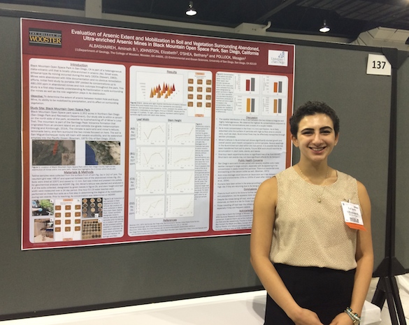
Wooster, OH – If you’ve been following our summer research adventures, you know that Amineh AlBashaireh (’18) has been hard at work studying the compositions of soils around abandoned mines in Black Mountain Open Space Park in San Diego, CA. She wrote the following abstract for the Geological Society of America Annual Meeting in Denver, Colorado this September.

Amineh AlBashaireh ('18) collecting a soil sample surrounded by miner's lettuce outside of Koala Mine in Black Mountain Open Space Park, San Diego, CA.

Amineh AlBashaireh (’18) collecting a soil sample surrounded by miner’s lettuce outside of Koala Mine in Black Mountain Open Space Park, San Diego, CA.

Evaluation of Arsenic Extent and Mobilization in Soil and Vegetation surrounding abandoned, ultra-enriched Arsenic Mines in Black Mountain Open Space Park, San Diego, California to GSA

ALBASHAIREH, Amineh B.1, JOHNSTON, Elizabeth2, O’SHEA, Bethany2 and POLLOCK, Meagen1, (1)Department of Geology, The College of Wooster, 944 College Mall, Wooster, OH 44691, (2)Environmental and Ocean Sciences, University of San Diego, 5998 Alcala Park, San Diego, CA 92110

Black Mountain Open Space Park in San Diego, CA is part of the Santiago Peak Volcanic Formation, a heterogeneous meta-volcanic unit that is locally ultra-enriched in arsenic (As). Small scale, artisanal-type As mining occurred during the early 1920s. Mines were abandoned with little documentation and no obvious remediation efforts. Initial field study by portable XRF yielded As concentrations up to 480,000 ppm in abandoned mines and rock outcrops throughout the park. This study is a first step towards understanding As fractionation in soils surrounding the mines. Twelve samples from the surface 5 cm of soil were collected in a ~48 m2 grid between two of the abandoned mines to determine how As concentration varies spatially, the degree of As mobilization during rain events, and how plants sequester As and affect soil As. Soils were pressed into pellets for analysis via WDXRF, and LOI was used to distinguish between organic and mineral-rich soils. To simulate transport by precipitation, 1:5 DI water leaches were performed on soils for 1 h, 24 h, and 7 day periods. Vegetation (miner’s lettuce, lemonade berry, and fern) was collected from the grid and will be analyzed by SEM-EDS for the extent of As throughout plant roots and bodies. While the crustal average for As is 1.5 ppm, soil concentration of As varies from hundreds of ppm to tens of thousands of ppm between the two mines. Consistent with hypotheses, the two greatest As concentrations occurred in rocky soils, possibly due to the presence of waste rock in the naturally occurring San Miguel-Exchequer rocky silt loam. Vegetation in the area appears healthy, but is not growing consistently across the grid, so SEM data will be compared with soil organic matter content and As concentration. San Diego’s semi-arid climate causes low precipitation and increased rates of soil erosion, making aeolian dispersion a likely mode of As transport. Consequently, there’s a potential health risk for those traveling off trail to visit the mines, hiking along the trails, and living in the canyon outlet. This is the first soil-plant arsenic study in a broader project aimed at understanding potential impact to public health. Additionally, this project has implications for the geologic occurrence of extreme As concentrations in igneous rocks from island arc settings.

filtration

Filtration step of 24h deionized water leach on <1.0 mm Black Mountain soil.

After the prescribed leach time, samples are centrifuged and filtered using a syringe fitted with a nylon filter to separate leachate (amber to red liquid above) from soil.

Posted in Uncategorized | Tagged , , , , , , , , , | 3 Comments

Keck Iceland takes over the Wooster Lab

Wooster, OH – Keck Iceland 2016 by the numbers:

  • Scientists in Keck Iceland: 10
  • Time in the field: 14 days
  • Pillows described in detail: >40
  • Samples collected: 71
  • Structural measurements made: 94
  • Photos taken: >2000
  • GPS data recorded: ridiculous

With a few extra charges for baggage fees, and a lot of help from the airport luggage carts, we successfully returned to Wooster to begin processing our samples and photos.

For the samples that we want to analyze for geochemistry, our first step is to powder them. Rachel Heineman ('17, Oberlin College) is cutting her samples on the rock saw.

For the samples that we want to analyze for geochemistry, our first step is to powder them. Rachel Heineman (’17, Oberlin College) is cutting her samples on the rock saw.


Cara Lembo ('17, Amherst College) is hammering her rocks into smaller pieces, preparing them for the shatterbox.

Cara Lembo (’17, Amherst College) is hammering her rocks into smaller pieces, preparing them for the shatterbox.

Every student has a project box in which they're keeping all of their materials. Rachel's is organized with thin section billets on the left, powders in the middle, and pieces to archive on the right.

Every student has a project box in which they’re keeping all of their materials. Rachel’s is organized with thin section billets on the left, powders in the middle, and pieces to archive on the right.

Some of the boxes look like this one, though. (Cara)

Some of the boxes look like this one, though. (Cara)

For samples that we want to analyze for trace elements, we prepare pressed powder pellets. Carl-Lars is showing Cara how to use the manual press to compress the powder in the die into a solid pellet.

For samples that we want to analyze for trace elements, we prepare pressed powder pellets. Carl-Lars is showing Cara how to use the manual press to compress the powder in the die into a solid pellet.

The result of all of our hard work is a desiccator full of samples ready for the XRF.

The result of all of our hard work is a desiccator full of samples ready for the XRF.

Another part of our work involves analyzing the compositions of volcanic glasses. Chloe Wallace ('17, Wooster) is picking out the freshest glass so that she can polish it for analysis by FTIR (Fourier Transform Infrared Spectroscopy) and Electron Microprobe. The FTIR will allow us to measure H2O contents while the microprobe will give us chemical compositions over small spatial scales.

Another part of our work involves analyzing the compositions of volcanic glasses. Chloe Wallace (’17, Wooster) is picking out the freshest glass so that she can polish it for analysis by FTIR (Fourier Transform Infrared Spectroscopy) and Electron Microprobe. The FTIR will allow us to measure H2O contents while the microprobe will give us chemical compositions over small spatial scales.

Lab work entails more than physical preparation of samples. Michelle Orden ('17, Dickinson College) and Anna Thompson ('17, Carleton College) are analyzing high-resolution photos of pillow lavas to understand the physical volcanology.

Lab work entails more than physical preparation of samples. Michelle Orden (’17, Dickinson College) and Anna Thompson (’17, Carleton College) are analyzing high-resolution photos of pillow lavas to understand the physical volcanology.

Michelle is identifying fracture patterns in her images.

Michelle is identifying fracture patterns in her images.

Anna and Ben Edwards (Dickinson College) are identifying vesicle patterns in pillow lavas.

Anna and Ben Edwards (Dickinson College) are identifying vesicle patterns in pillow lavas.

It's not all work, of course. We occasionally take breaks to play wiffle ball and frisbee on the quad.

It’s not all work, of course. We occasionally take breaks to play wiffle ball and frisbee on the quad.

Posted in Uncategorized | Tagged , , , , , , , , | 1 Comment

Wooster Geologist at Argonne National Laboratory

ANL_PMS_P_HEditor’s note: The following post is from guest blogger Clara Deck (’17) about her research experience this summer with an internship at one of the world’s most prominent laboratories. She is working on an important climate change project involving the carbon budget of permafrost. Last summer Clara completed a dendrochronology climate project in Wooster with Dr. Greg Wiles.

This summer I am working as a research intern at Argonne National Laboratory in Illinois as part of the ten week Student Undergraduate Laboratory Internship (SULI) program. The laboratory occupies 1500 acres located just north of Chicago and is a Department of Energy (DOE) facility. I have the privilege of joining Dr. Julie Jastrow and her terrestrial ecology research team on a project focused on organic carbon stocks in permafrost across Alaska. Soils serve as the largest terrestrial carbon reservoir, containing more than two times the amount of carbon found in the atmosphere.
Image 2About 25% of land mass in the northern hemisphere is dominated by permafrost soils. The long term goal of this project is to improve estimates of the total quantity of C contained in permafrost, as findings to-date are immensely variable. This is important because soil carbon will be affected by environmental change, especially in high latitude regions.

(Canadian Soil Information Service)

(Canadian Soil Information Service)

Field sampling targets features known as ice wedge polygons, which form similarly to mud cracks, but then fill with ice. The soil within these polygons is characterized by substantial cryoturbation, or mixing, due to freeze-thaw processes.

(Julie Jastrow, Argonne National Laboratory)

(Julie Jastrow, Argonne National Laboratory)

A trench like this is dug across a polygon, in order to sample from each distinguishable layer across an entire transect. This summer, I am performing fractionation procedures on these samples, which means separating the soil into different size components. The fractions will then be analyzed for carbon content.  I will then use GIMP Image Manipulation Software to convey C density data in a cross sectional image of the polygon.

(J.D. Jastrow (Argonne National Laboratory) and C.L. Ping (University of Alaska Fairbanks), unpublished data)

(J.D. Jastrow (Argonne National Laboratory) and C.L. Ping (University of Alaska Fairbanks), unpublished data)

(IJ.D. Jastrow (Argonne National Laboratory) and C.L. Ping (University of Alaska Fairbanks), unpublished data)

(IJ.D. Jastrow (Argonne National Laboratory) and C.L. Ping (University of Alaska Fairbanks), unpublished data)

These diagrams illustrate the progression from a field sketch to a digital image showing C density in a polygon cross section. Ice wedge polygons adhere to large scale patterns across the landscape, so data from each polygon has upscaling potential for larger models. Further studies will include analysis of the carbon decomposability and the depth to which permafrost will thaw with predicted temperature rise.

I am excited to be at Argonne conducting research so closely related to modern climate change, and will be continuing these studies throughout the year for my Senior Independent Study. Thanks for reading!

Posted in Uncategorized | Tagged , , | 8 Comments

Wooster’s Fossils of the Week: A molluscan assemblage from the Miocene of Maryland

1 Calvert Zone 10 Calvert Co MD 585Earlier this month a gentleman stopped by The Department of Geology and donated the above beautiful slab of fossils to our program. Dale Chadwick of Lancaster, Pennsylvania, is an avid amateur fossil collector with a very useful website and considerable generosity. His gift to the department makes an excellent Fossils of the Week entry. Later I’ll show you the equally-impressive other side of this specimen!

We have here a fine sandstone from the famous Calvert Formation (lower to middle Miocene) exposed at the Calvert Cliffs, Plum Point, Calvert County, Maryland, in the stratigraphic Shattuck Zone 10. As you can see, some horizons are densely fossiliferous with large numbers of gastropods and bivalves. This is what we refer to us a death assemblage, meaning these shells are not preserved in their life positions but how they accumulated just before final burial. These rocks and their fossils were the initial basis of Susan Kidwell’s important work on taphonomic feedback, or how shell accumulations affect the succeeding living communities.

So what are the prominent fossils in this slab? Dale has the answers on his website. I’ve annotated the image and made a list below:

2 Calvert Zone 10 Calvert Co MD 585 labeledA Turretilla variabilis (a turritellid gastropod)
B Stewartia sp. (a lucinid bivalve)
C Turritella plebia (a turritellid gastropod)
D Cardium laqueatum (a carditid bivalve)
E Siphonalia devexa (a buccinid gastropod)

So how did several of these animals die on that seafloor long ago? You’ve probably guessed predation by looking at that round hole in specimen B, a lucinid bivalve.

3 Naticid borehole Calvert 585The beveled nature of this round drillhole tells us it was made by a predatory naticid gastropod, which used its radula (a tongue-like device with sharp teeth) to penetrate the calcareous shell and damage the muscles holding it tight against the attack. About half the specimens in this slab show similar predatory penetrations. Wooster alumna Tricia Kelley did critical work on predation styles, intensities and evolutionary patterns with Calvert specimens like these.

Thank you again to Dale Chadwick for his gift!

References:

Kelley, P.H., 1983, Evolutionary patterns of eight Chesapeake Group molluscs: Evidence for the model of punctuated equilibria: Journal of Paleontology 57: 581–598.

Kelley, P.H. 1988. Predation by Miocene gastropods of the Chesapeake Group: stereotyped and predictable. Palaios 3: 436-448.

Kidwell, S.M. 1986. Taphonomic feedback in Miocene assemblages: Testing the role of dead hardparts in benthic communities: Palaios 1: 239–255.

Kidwell, S.M., Powars, D.S., Edwards, L.E. and Vogt, P.R. 2015. Miocene stratigraphy and paleoenvironments of the Calvert Cliffs, Maryland, in Brezinski, D.K., Halka, J.P. and Ortt, R.A., Jr., eds., Tripping from the Fall Line: Field Excursions for the GSA Annual Meeting, Baltimore, 2015: Geological Society of America Field Guide 40, p. 231–279.

Posted in Uncategorized | Tagged , , , | Leave a comment

Wooster’s Fossil of the Week: An ammonite from the Middle Jurassic of southern England

Leptosphinctes microconch Jurassic Dorset 585We’re featuring just a workaday fossil this week because of other summer activities. This is the ammonite Leptosphinctes Buckman 1929 from the Inferior Oolite (Middle Jurassic) at Coombe Quarry, Mapperton, Dorset, southern England. Cassidy Jester (’17) and I collected it last month during our 2016 England research expedition. Our friend Bob Chandler generously identified it. It popped out of a rock we were pounding into submission, providing a direct application of ammonite biostratigraphy to our work. As with many ammonites, the group is well known but the names are still a bit dodgy.

This specimen is a microconch, meaning it is the smaller version of a species pair, the larger being the macroconch. It is presumed that this is sexual dimorphism and that the microconch is the male because it didn’t need to carry resources for egg-laying. This is one reason why the taxonomy of these ammonites is in perpetual revision.

References:

Buckman, S.S. 1909–1930. Yorkshire Type Ammonites & Type Ammonites. Wesley & Son, Wheldon & Wesley, London, 790 pl.

Chandler, R B., Whicher, J., Dodge, M. and Dietze, V. 2014. Revision of the stratigraphy of the Inferior Oolite at Frogden Quarry, Oborne, Dorset, UK. Neues Jahrbuch für Geologie und Paläontologie-Abhandlungen 274: 133-148.

Galácz, A. 2012. Early perisphinctid ammonites from the early/late Bajocian boundary interval (Middle Jurassic) from Lókút, Hungary. Geobios 45: 285-295.

Pavia, G. and Zunino, M. 2012. Ammonite assemblages and biostratigraphy at the Lower to Upper Bajocian boundary in the Digne area (SE France). Implications for the definition of the Late Bajocian GSSP. Revue de Paléobiologie, Vol. spéc, 11: 205-227.

Posted in Uncategorized | Tagged , , , | Leave a comment