A splash into the Jurassic on our last Negev field day

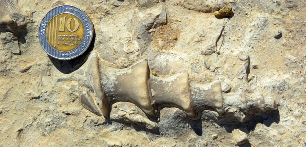
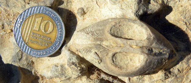
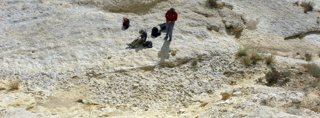
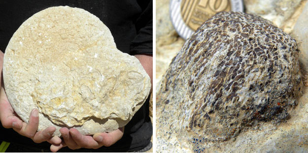
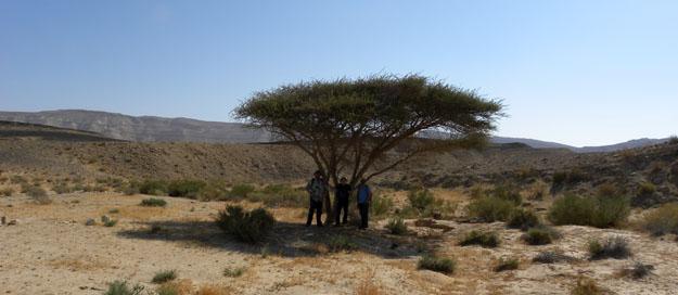
MITZPE RAMON, ISRAEL — Today we traveled northeast of Mitzpe Ramon to Makhtesh Gadol (“The Large Crater”) to look at some Jurassic fossils in the Matmor Formation.  I had to take a few photographs and collect some cool crinoids there, but otherwise it was a kind of busman’s holiday for us.  The Matmor Formation preserves a tropical marine fauna with loads of mollusks, echinoderms, brachiopods, sponges and corals.  Several sets of Wooster students have worked here, and our friend Yoav still refers to stratigraphic sections by Wooster student names: Jeff, Elyssa, Sophie and Meredith.  In fact the most important stratigraphic unit in the Matmor we know as “Meredith-1”.  It was a fitting place to end our Wooster 2010 Israel fieldwork.

An abraded high-spired snail in the Matmor Formation (Middle Jurassic). The original skeletal aragonite has been replaced by calcite.

An articulated infaunal bivalve still in place perpendicular to bedding. The dorsal area has been shaved off by erosion on the outcrop.

The Negev Boys on their last field day. From the left, Wooster seniors Micah Risacher and Andrew Retzler, and on the right Stuart Chubb (Birkbeck College, London, graduate student). I am not responsible for the choice of shirts.

Posted in Uncategorized | Tagged , , , | 3 Comments

Thraspberry Thrashing

All of us by the Bartlett River.

guest blogger: Stephanie

It’s been a full week! On Monday, Justin (the captain) and Tom (captain of another boat who Justin was training for the Capelin) took all of us around to climate stations Dan maintains throughout the park to offload data and repair any snow/bear damage. We went up the West Arm and saw several beautiful glaciers. We stayed that night at the Russell Cove raft, a raft for researchers (not all of us fit…so we got to sleep on the island!). Greg found a new toy.

Greg, Deb, & Dan hard at work at a climate station.

The well-used "ursabahn" by one of the stations.

The Wooster flag in the West Arm.

Free ice! Justin nets a couple small icebergs for the cooler.

Home sweet home--the researchers' raft.

A new toy for Greg.

Tuesday the Capelin’s unidentified mechanical problems seemed to worsen, so the day was called off and Greg and I were dropped off at Sandy Cove. As we drove in, we scared a moose off the coast, and not long after a black bear came rolling long grazing on the grass. We got a late start (and subsequently a very late finish…) up Mount Wright. After about 4-5 hours of nothing in view but thorny brambles and devil’s club (which I am still picking out of my hands), we finally made it to the top of one of the ridges to find a beautiful landscape of karren limestone outcrops, snow, and mountain hemlocks. We made a quick side trip to the nearest top (~3000 ft) just for fun, looked down on a goat (always a good sign), and then got to work. It was 8 or 9 before we finished sampling, so we took an express route down and had a nice walk in the almost dark along the coast (every boulder looked like a bear…). Along the way we came across an awesome tufa waterfall, where the water was coming out through the limestone and precipitating (like in a cave). Unfortunately, it was too dark to get a good picture.

A welcome view.

Mushrooms! In the snow!

Steph at 3000 ft.

Greg at 3000 ft, with the Beardslees in the background.

The next day we walked along the river looking for interstadial wood (trees that were run over by glaciers and then buried). We didn’t find any, but we did find a good lunch spot, where we could ponder over the delta sediments the stream was cutting through and later piece it with the lake sediments farther up. The glacier, when it came down to the mouth of this valley, had blocked it off and formed a lake here.

An interesting outcrop (I know, I know, no scale. I think the bushes are ~4-6 ft.)

A relaxing lunch (we earned it!).

A nicely stuck boulder.

Meanwhile, Deb, Dan, and Justin were trying to get our boat situation worked out. The Capelin was pronounced ok, but quickly showed it wasn’t, and they were able to negotiate using a different one. The Petrel was much speedier than the Capelin, but required a ladder to get in and out on shore and didn’t like rough water very much. They met up with us at Sandy Cove on Wednesday and joined us in the ranger raft that was there (much like the researchers’ raft, without the star wars sheets…).

Thursday was another, very buggy, climate station, and then Gieke Inlet, where they had some radiocarbon dates on interstadial wood going back 3000 yrs. The particular outwash we were in had, according to Dan, been formed in a couple days of rain in November of 2005, so it was pretty rich with wood being weathered out.

Dryas patches in Gieke Inlet--the first plant to move in once the glaciers recede.

We came back to Gustavus Thursday night (showers!!!), and went out with Tom on Friday, again looking for interstadial wood. We went to Willoughby Island, where we found some really cool layers of peaty organics under gray silt/clay under gravely glacial sediments. Bad weather rolling in made it an early day, and that night we went to open mic night at the pizza place, where I realized just how much talent could be squeezed into a little town like Gustavus.

A stump (spruce, we think) in growth position at Willoughby Island.

Dan left Saturday morning, and more bad weather resulted in the calling off of our plans to go to Pleasant Island to look at Cedars stripped by the natives (the Tlingit). Instead, we went kayaking in the Beardlees and got hammered by some rain and hard wind. Much fun! The night was topped off by our housemates, sea otter researches with USGS, bringing back a huge king salmon they had caught (they forced me to try some…). Yesterday we made the trek up Excursion Ridge, where we got to see the new hydroelectric dam that is now powering Gustavus and do some slip and sliding on the steep snow patches. Got lots of good samples, and came back to find out the otter folks had caught another king salmon. They happily shared again 🙂

The dam that powers Gustavus.

Lunch...I'm sensing a pattern here...

Flowers! On the way up we came across several meadows and bogs.

A good view of Gustavus.

This morning, it’s back to Juneau. Mendenhall glacier is in the plans, as is a look around town. It’s back to Wooster on Wednesday.

Posted in Uncategorized | Tagged , , | 3 Comments

Last Field Day in the Cretaceous of the Negev

MITZPE RAMON, ISRAEL — We spent our last Cretaceous field day in our section of the Zihor and Menuha Formations just south of Makhtesh Ramon.  It is a complicated place because of tectonic activity from the Late Cretaceous on, so we spent a lot of time tossing measuring tape off cliff edges to calculate unit thicknesses.  The most exciting moment was when two Israeli fighter jets flew very low through a little pass in which we were working.  The sudden noise and blast of air nearly knocked us down.

We finished our sections, collected our last samples, and headed back to our little house in the afternoon.  Tomorrow we will visit Makhtesh Gadol to the northeast to look at Jurassic rocks which have been studied by previous sets of Wooster students.

Two beautiful fossil shark teeth and a bit of bored oyster Andrew Retzler found during his last visit to the Menuha Formation (Upper Cretaceous) south of Makhtesh Ramon. The teeth are of Scapanorhynchus ("spade snout") which ate soft-bodied prey and had a protrusible mouth. The oyster is bored by my old friends the clionaid sponges, producing the ichnogenus Entobia.

Posted in Uncategorized | Tagged , , , | Leave a comment

An igneous rock for Dr. Pollock

Micah Risacher and Andrew Retzler exploring a stock of nordmarkite in the Gevanim Valley, Makhtesh Ramon, southern Israel. It is somewhat rudely intruded into the Gevanim and Saharonim Formations we're studying. How do we know it's nordmarkite? We're just that good.

Posted in Uncategorized | Tagged , , | 1 Comment

A dip into Triassic seas

MITZPE RAMON, ISRAEL — We wish there was still some water in those seas because it was 41°C (106°F) this afternoon, but alas the only water we saw was that which was warmly sloshing in our plastic bottles.  Today we looked at the Middle Triassic in the southern limb of Makhtesh Ramon as part of a project for Sarah Greene, a graduate student at the University of Southern California.  She is working on fossil shellbeds as indicators of the tempo and mode of the Triassic recovery from the Permian extinctions.  We are providing information from the Gevanim and Saharonim Formations.  The shellbeds were easy to find, describe and measure.

The Gevanim Valley showing the Gevanim Formation in the foreground and the Saharonim as the yellowish unit in the upper right. Not a lot of shade here, you might notice.

Cross-section view of one of the Middle Triassic shellbeds in the Saharonim Formation.

Posted in Uncategorized | Tagged , , | 1 Comment

Holiday travel in southern Israel

MITZPE RAMON, ISRAEL — Today we took the usual weekly shabbat break from fieldwork and spent the day as tourists.

Micah and Andrew exploring blocks of halite (rock salt -- sodium chloride) exposed on the slopes of Mount Sodom in the Dead Sea Rift Valley. This salt is part of a massive diapir (a "salt dome") which rose from below and punched its way up through the overlying sediments because of its relatively low density.

One of the remarkably preserved Roman fortified camps from the siege of Masada, 73-74 CE. This is a view down from the northern extremity of the Masada plateau.

The obligatory "student floating in the Dead Sea" photograph. This time the brave soul is Andrew Retzler.

Mamshit is the site of a Nabatean city on the Incense Route ("Spice Road") from Asia to the West. It flourished from the middle of the first century to the middle of the seventh century CE. It is located a few kilometers east of the modern Israeli city of Dimona.

Posted in Uncategorized | Tagged , , , | Leave a comment

The last of Scorpion Wash

MITZPE RAMON, ISRAEL — The 2010 Wooster Geology Israel team finished its work today in the Upper Cretaceous rocks at our northern locality, Wadi Aqrav.  We measured several dozen cobbles from the base of the Menuha Formation, and then collected fossils from the Zihor Formation which we had previously measured.  We are now looking forward to a shabbat dinner at the home of our hosts Yoav and Noa, and then a trip tomorrow to visit Masada and the Dead Sea.

View of the cobble-bearing bedding plane at the base of the Menuha Formation (Late Cretaceous) from the cliff above.

An abraded oyster attached to the bored surface of one of the cobbles. This is the kind of hard-substrate paleontology I enjoy.

On the left is a large ammonite found in the middle of the Zihor Formation. It is encrusted on one side by oysters. On the right is a bit of vertebrate bone incorporated in the cobbles at the base of the Menuha Formation. (Yes, I think it must be from a dinosaur.)

Posted in Uncategorized | Tagged , , , , | 1 Comment

Wooster’s first dinosaur! (Well … maybe.)

Wooster's first dinosaur! (Well … maybe.)

MITZPE RAMON, ISRAEL — This morning while collecting fossils in the Zihor Formation (Upper Cretaceous) we found the above bones and several other smaller fragments.  They are reptile bones as shown by their density and configuration.  The shape of the larger piece looks dinosaurian to me, but it may be wishful thinking.  We will turn them over to the Survey and park authorities, along with their exact location coordinates, so that maybe later a vertebrate paleontologist will examine them and explore the site further.  Dinosaurs are very rare in the Middle East so this could be a good story someday.  In any case, it was fun being vertebrate paleontologists for awhile!

UPDATE: Mosasaur bones, it turns out. Just as cool, I say.

Posted in Uncategorized | Tagged , , , | 2 Comments

Yes, we are finding plenty of fossil shark teeth in the Negev

Andrew Retzler holds the teeth he found at one location in the Menuha Formation (Upper Cretaceous) during today's fieldwork.

Posted in Uncategorized | Tagged , , , | Leave a comment

Wooster Geologists in Egypt! (Briefly, and just a few inches over the border)


Near HAR ARIF, SINAI PENINSULA, EGYPT — An unscheduled visit, it was.  This morning we needed to park our rental car at a border post so that we could all jam into a 4-wheel drive vehicle from the Geological Survey to travel some rough roads.  Approaching the base, our Israeli colleague noticed that someone had left the gate open to the border road which runs north.  We dashed through it so that we could look down into Sinai.  We drove until we found a hole in the border fence, leaped out and took photographs of the spectacular Wadi Arish below us, and then quickly drove back through the gate before anyone noticed.  No one did!

Wadi Arish. Good morning, Egypt!

Posted in Uncategorized | Tagged , , | 4 Comments