The utility of trace fossils

LOGAN, UTAH–Today we hiked north of Tony Grove Lake in Logan Canyon to explore an Ordovician sequence of rocks. The most interesting unit (to my surprise) was the Swan Peak Quartzite, an orange-brown unit at the base of a white dolomite and gray limestone. It weathers in sharp edges and large blocks tumbled down the slopes. Quartzite began as a quartzose sandstone which was metamorphosed into a rock where the silica cement is as hard as the quartz grains. Most fossils are destroyed in this metamorphosis, along with almost all sedimentary features, so I didn’t expect to see much in the Swan Peak.

Outcrop of the Swan Peak Quartzite (Ordovician) north of Tony Grove Lake, Utah. This photograph was taken facing north at N41° 54.198′, W 111° 38.72′.
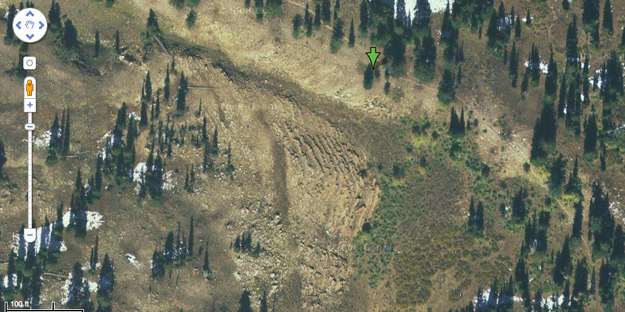
Google Earth image of the Swan Peak Quartzite exposure. The green arrow is the location from where the outcrop photograph above was taken. The stepped nature of the rocks is easily visible in the middle of the image.

The Swan Peak Quartzite is exposed here as a series of large steps looking something like a side of an eroded Egyptian pyramid. Why does it erode into this kind of stairway instead of one large block? A close examination of the rock surfaces revealed trace fossils were preserved — the kind of fossils which could be clues to the character of this formation.

Horizontal burrow systems preserved in remnant bedding planes of the Swan Peak Quartzite. These traces give the rock its local name of “Fucoidal Quartzite”. Fucoidal is an old word for trace fossils.
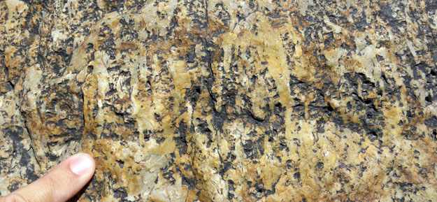
Vertical burrow systems (Skolithos) exposed on vertical faces of the Swan Peak Quartzite.

It appears that the step surfaces have horizontal burrow systems, and the “risers” have vertical burrows (Skolithos). There is an alternation of beds with horizontal burrows and beds with vertical burrows through the Swan Peak Quartzite. The horizontally-burrowed units are less resistant than the vertically-burrowed units, so this alternation produces the stepped erosion pattern.

My hypothesis is that the horizontal burrows represent slightly deeper water than the vertical burrows, based on the distribution to such burrow systems in other formations and in today’s oceans. The alternation between the two trace fossil types may thus show fluctuating sea levels as the Swan Peak sediments were deposited way back in the Ordovician.

So, this unpromising rock may indeed be providing clues to its ancient depositional environment through the trace fossils it contains.

[Author’s note (July 27, 2020): Dave Powelson kindly pointed out to me that the Swan Peak Quartzite is not actually a metamorphic quartzite but a silica-cemented orthoquartzite sedimentary rock. I should have called it by its more neutral name, the Swan Peak Formation. This solves the mystery of why the trace fossils are so well preserved. Thanks, Dave!]
Posted in Uncategorized | Tagged , , | Leave a comment

Ancient shorelines

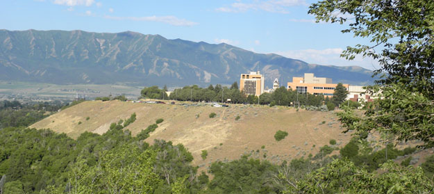
LOGAN, UTAH–The Wooster geology team currently in central Utah pointed out in the distance Pahvant Butte which has a set of relict shorelines from the famous — and immense — Lake Bonneville. In the spirit of sharing common field experiences between Wooster geologists this summer, we have Bonneville shorelines up here in northern Utah as well. This pluvial lake was extraordinarily large, filling a good portion of the Great Basin between 32,000 and 14,500 years ago. Its shores were energetic with strong waves pounding away at the confining mountain slopes and forming wave-cut platforms which extended inland hundreds of meters in some places. The area around Logan, Utah, has especially well developed Bonneville shoreline platforms.

Looking west at the Utah State University campus in Logan sitting on a Lake Bonneville wave-cut platform. In the background are the Wellsville Mountains, with the Cache Valley in between.

Wave-cut platforms (or terraces) on the flank of the Bear River Range in Logan, Utah. The oldest levels are the highest because they have eroded away previous shorelines. The lower platforms represent decreasing lake levels over time.

The Great Salt Lake of Utah is a remnant of the once vast Lake Bonneville. Tomorrow I hope to see where the lake catastrophically drained about 14,500 years ago (the Bonneville Flood).

Posted in Uncategorized | Tagged , | 1 Comment

Hey Icelandic Researchers, We’ve Got Some Basalt, Too!!

After many successful field days in sedimentary strata, yesterday we had a day of exploration. We traveled with the Ohio State field camp to Fillmore, Utah, to investigate the Black Rock Desert. Specifically, we spent our time in the Ice Springs Volcanic Field, which provides the youngest volcanic activity in the Black Rock Desert (~600 years old).

We thought that the Icelandic Team would be especially interested in some of our photos, since basalt seems to be near and dear to their hearts.

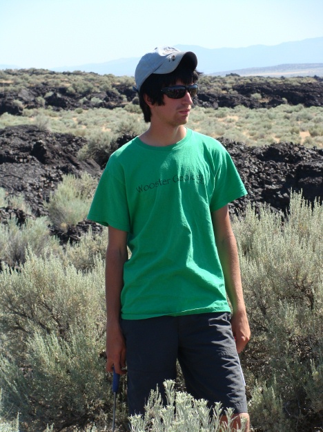
Jesse Davenport, studious as ever, is listening intently to a lecture on the Ice Springs Volcanic Field.  The rough, brecciated aa of the field is behind him.

Jesse Davenport, studious as ever, is listening intently to a lecture on the Ice Springs Volcanic Field. The rough, brecciated aa of the field is behind him.

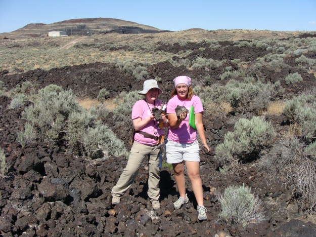
Elyssa Krivicich (left, '09) and Elizabeth Deering (right) proudly display the Utah basalt.  The Red Dome cinder cone is in the background.  Hey Dr. Pollock and Becky Alcorn (our Icelandic Team)...do you like it?

Elyssa Krivicich (left, '09) and Elizabeth Deering (right) proudly display the Utah basalt. The Red Dome cinder cone is in the background. Hey Dr. Pollock and Becky Alcorn (our Icelandic Team)...do you like it?

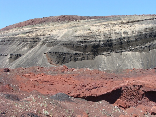
This is a photo of a cross-section through the Red Dome cinder cone, which is quarried for landscaping purposes.  Take a look at the pronounced bedding that is due to successive pulses of air-fall deposits.  We collected volcanic blocks and bombs both at the base of the cinder cone and then at the very top.

This is a photo of a cross-section through the Red Dome cinder cone, which is quarried for landscaping purposes. Take a look at the pronounced bedding that is due to successive pulses of air-fall deposits. We collected volcanic blocks and bombs both at the base of the cinder cone and then at the very top.

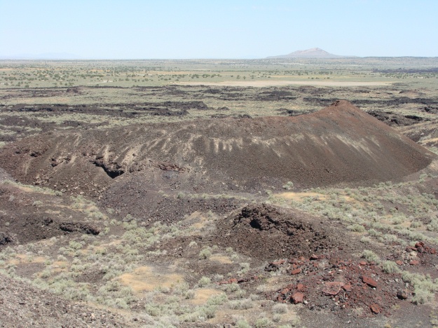
The view from the top of the Red Dome cinder cone is amazing.  You can see a smaller cinder cone nearby.  In the distance, you can see Pahvant Butte.  If you look close enough, the ancient shorelines of Lake Bonneville are exposed at the base of Pahvant Butte.

The view from the top of the Red Dome cinder cone is amazing. You can see a smaller cinder cone nearby. In the distance, you can see Pahvant Butte. If you look close enough, the ancient shorelines of Lake Bonneville are exposed at the base of Pahvant Butte.

Posted in Uncategorized | Tagged , | 4 Comments

Cutting through the Paleozoic in northern Utah

LOGAN, UTAH–Logan Canyon cuts perpendicularly through the Bear River Range in Cache County, northern Utah. It neatly dissects a complex section of Paleozoic sedimentary rocks in the Logan-Huntsville Allochthon noted in my last post. Conveniently, US Highway 89 runs through the length of the canyon providing spectacular views of the quartzites, dolomites and limestones.

The mouth of Logan Canyon as viewed from Logan, Utah.

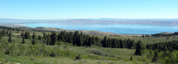
After exiting the canyon in the east, Highway 89 meets a most unusual body of water with a prosaic name: Bear Lake. Running north-south across the Utah-Idaho border, Bear Lake is one of the oldest existing lakes in North America. Studies of its sediments show the lake has existed for at least 220,000 years, and maybe more. Its water is strangely blue because it contains lots of dissolved calcium carbonate from the surrounding limestone mountains in its watershed. The lake was formed by tectonic processes, sitting now in a half-graben which is still active. Its human history is interesting too — in the early 19th Century it was a gathering point for mountain men, including Jim Bridger and my hero Jedediah Smith.

Bear Lake viewed from the west in the Bear River Range.

Posted in Uncategorized | Tagged , | 2 Comments

Let the Work Begin

Guest blogger: Becky Alcorn

Today was our first day of field work in Undirlithar quarry. Although a lot of the quarry has been filled in in the last year, we had a very successful day and found three dikes that can be used in my IS. We began mapping the south wall that will be the focus of my IS and collected several samples for future analysis when we return to Wooster. We’re even returning to the quarry later tonight to continue our work since the sun never sets and we never sleep.

The smallest of the three dikes I will be working with

A close up on some wonderful plagioclase (about 1cm) and olivine crystals in the same dike as above

Trying to see the "sparkly" vesicles in a sample

Breaking in my new rock hammer on my first sample

Posted in Uncategorized | Tagged , , | 3 Comments

Yet another Wooster geologist in Utah

LOGAN, UTAH–I’m here to spend a few days with my parents who are “summer citizens” on the Utah State University campus. Logan is in the far northeastern corner of Utah near Idaho.  Like all of the state, it has fascinating geology. Only California can match Utah for geological diversity and splendor. There is a reason why so many geologists find themselves coming back often to Utah.

This evening we walked to the eastern edge of the USU campus and looked at the Bear River Range a few kilometers away. It is a very complex packet of rocks, part of the Logan-Huntsville Allochthon (an allochthon is a set of Paleozoic rocks pushed out of place by tectonic activity). The East Cache Fault Zone separates the valley which contains Logan from the mountains.  Some geologists believe it represents the boundary between the Basin and Range Province to the west and the Middle Rocky Mountains Province to the east.  In the image below you can see that the zone is primarily a set of normal faults. In the Logan area it shows movement during the Holocene, and it is still active today.

Looking east at the Bear River Range from Logan, Utah. The East Cache Fault Zone is in the foreground. Note the faceted spurs on the flanks of the mountains.

Tomorrow we explore Logan Canyon, which cuts perpendicularly through the Bear River Range, and look at the exposed carbonate rocks in detail. I can smell the fossils from here.

Posted in Uncategorized | Tagged , | Leave a comment

The Golden Circle Tour

Guest Blogger: Becky Alcorn

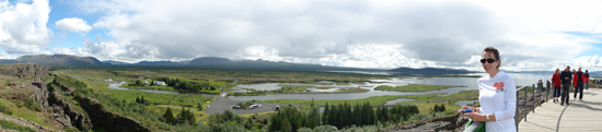
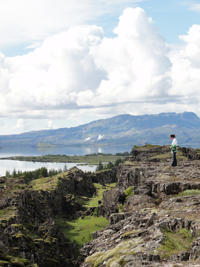
Today we took the Golden Circle tour in Iceland. I think I saw more amazing geologic sites on this one tour than I’ve ever seen before. Our tour began at Thingvellir in the rift valley where we hiked along the Mid-Atlantic Ridge and spent a good deal of time trying to calculate the spreading rate. We then drove to Geysir where I saw my first geyser! (and enjoyed the wonderful smell of sulfur). I also got to enjoy my first taste of hamburger sauce at the visitor center there. Our tour ended with a stop at Gullfoss, an incredible waterfall with only a small rope in some places to prevent you from falling in (take your kids at your own risk, I guess).

A panoramic view of Thingvellir

Standing on the edge at Thingvellir

The original Geysir

Strokkur geyser at Geysir

The Gullfoss (Golden Waterfall)

As you can see you can get as close to the water at Gullfoss as you'd like

Posted in Uncategorized | Tagged , , | 1 Comment

Mishaps with Hammers

Today was definitely another adventure in the field. Although we didn’t travel far from our home base in Ephraim (less than 1 mile from home), there was plenty of excitement. We tackled the Green River Formation at Gal Hill, which provided a 60 foot strat column of wonderful carbonates (and a 4 foot tuff bed).

Above is a scenic photo of Gal Hill.  The thick, massive bed about 8-10 feet off the road is a air fall tuff.  The stromatolite layer that we targeted is immediately below the tuff.  Poor stromatolites...they never had a chance!!

Above is a scenic photo of Gal Hill. The thick, massive bed about 8-10 feet off the road is a air fall tuff. The stromatolite layer that we targeted is immediately below the tuff. Poor stromatolites...they never had a chance!!

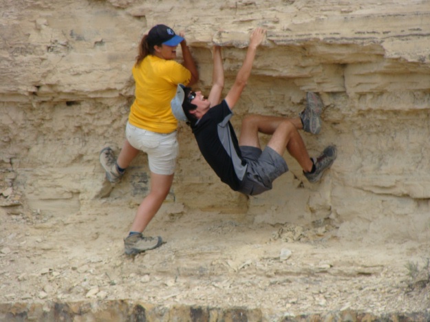
Of course, stratigraphy is all serious business, as Elizabeth and Jesse prove in the photo below:

Wooster's rock climbing team hard at work.

Wooster's rock climbing team hard at work.

We had to bring out “The Big Dog”, Jesse’s mega sledge hammer for some of our work today, as we needed to sample a continuous silicified stromatolite layer exposed along Gal Hill.

Elizabeth shows her enthusiasm for the silicified stromatolite layer, which is at hand level in this photo.

Elizabeth shows her enthusiasm for the silicified stromatolite layer, which is at hand level in this photo.

Throughout the morning, Jesse used the mega sledge hammer, chisels, and regular rock hammers to extricate a number of beautiful laterally linked and small domal stromatolites that we were measuring. In the end, though, I’m not too sure who came out on top: Jesse or the stromatolites.

Our motto of the day:  No pain, no gain!!

Our motto of the day: No pain, no gain!!

Posted in Uncategorized | Tagged , | 2 Comments

Ohio, Some Fun, A Little Bit of Geology, and Back

Guest Blogger: Jesse Davenport

We always hear about how all geologists have the opportunity to go to fantastic places in far away lands. Or at least that was what I thought, while I envied my professors from afar. However, this summer I have had the opportunity to travel across the United States, on a road trip no less. From conquering Grays Peak, Torreys Peak, and Pikes Peak in Colorado to backpacking 83 miles in 10 days in the New Mexico backcountry (not to mention being attacked by a black bear) to spending a few days in the Sawtooth National Forest, to climbing Mt St. Helens and Mt. Rainier, and back to central Utah. And yet my trip isn’t even halfway complete. After assisting Dr. Judge and Elizabeth in her I.S. fieldwork, I will then head to southwestern Montana to begin my fieldwork in the Tobacco Root Mountains, where I will be working with Archean metamorphic and igneous rocks, some of the oldest you can find in North America. Being able to drive everywhere also has had a number of exciting perks. I have visited Colorado School of Mines and University of Utah, two schools I have looked at and am very interested in for graduate school for a Mining Engineering degree. I will also have the opportunity to visit the Bingham Canyon Cooper mine near Provo, Utah with the OSU folks. Hopefully I will be able to send out another update once I begin my work in Montana!

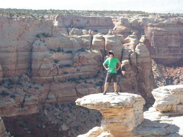
Jesse on top of the Colorado National Monument at 6,106 feet near Fruita, Colorado.

Jesse on top of the Colorado National Monument at 6,106 feet near Fruita, Colorado.

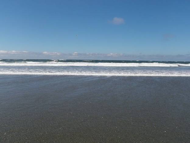
From Ohio to the west coast. A view of the Pacific Ocean near Ocean Shores, Washington.

From Ohio to the west coast. A view of the Pacific Ocean near Ocean Shores, Washington.

Posted in Uncategorized | Tagged , , | 4 Comments

Wooster geologist in New Zealand!

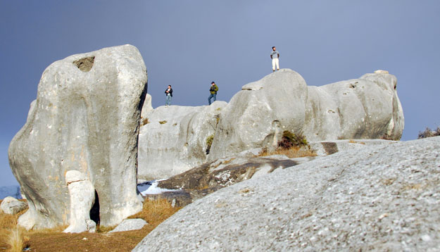
CHRISTCHURCH, NEW ZEALAND–And it’s not me! Wooster geology student Andrew Collins is in a study abroad program on the South Island of New Zealand.  He has promised to share with us his geological experiences now and then. Andrew recently traveled to a town called Springfield near Christchurch and visited some amazing Paleogene limestone exposures on Castle Hill. This is an extreme example of karstic weathering.

Paleogene limestone on Castle Hill, South Island, New Zealand. Photograph by Andrew Collins.

Beautiful, eh? Andrew will share more New Zealand geology with us through this blog and his own.

This summer we’ve had Wooster geologists in Alaska, the southern USA, Ohio, Israel, Iceland and Utah … and we’re only halfway through our field season. Gotta love it!

Posted in Uncategorized | Tagged , , | 1 Comment