


Back in 2018, some internal sophomore research funding through the College of Wooster allowed me to hire Anna Cooke (’20) to begin an investigation into rain-on-snow events in Alaska. Rain-on-snow is exactly what it sounds like: rain falling on top of snow. We see this fairly often in Ohio in winter, and our biggest problem with rain-on-snow is usually that all of that rain melts the snow packs. This makes flooding more likely because it’s not just the rain falling that raises river levels — it’s also the melting snow.

Figure 1: Alaskan caribou (photo credit: Alex Crawford)
But in Arctic environments, rain-on-snow can have a more insidious impact. If, instead of melting the snowpack, the rain trickles through the snow and cools down to the point of freezing, it will form lenses of ice at the base of the snow. That ice impedes that ability of animals like caribou (Figure 1) to access lichens on the ground below. Digging through snow is easy, but breaking through ice is energy-intensify at best and impossible at worse. Several examples of rain-on-snow followed by freezing and mass die-offs have been recorded in Alaska, Canada, Svalbard, Russia, and most recently Finland.
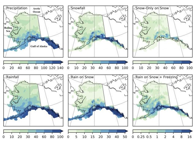
Figure 2: Counts per year for various precipitation events in Alaska from the MERRA-2 atmospheric reanalysis (1980-2018).
In a new paper just published in final form at Monthly Weather Review, we built on the work that Anna began as a sophomore researcher by applying a storm detection and tracking algorithm that I developed for my PhD and connecting rain-on-snow events at particular locations to the storms that generated them. This allowed us to answer questions that had never been addressed before, especially: Is there anything special about storms that produce rain-on-snow? Are they more intense than other storms? Are they generated in different ways? Do they take distinct paths? Answering such questions can better help us understand and predict these events, which sometimes have dire consequences for caribou/reindeer, musk oxen, and the people who rely on them. Dr. Karen Alley here at the College of Wooster and Dr. Mark Serreze at the University of Colorado Boulder helped out in the planning, interpretation, and writing of this project.
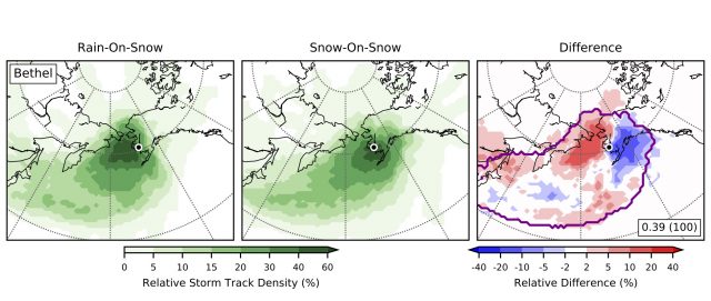
Figure 3: Distribution of storm tracks leading to (left) rain-on-snow and (center) only snow-on-snow in winter months at Bethel, Alaska. The right-hand plot shows where rain-on-snow-producing storms are more common (in red, e.g., the Bering Sea) and where snow-on-snow-producing storms are more common (in blue, e.g., the Gulf of Alaska). A statistical simulation for the region outlined in purple showed that two observed samples of storm tracks have more distinct spatial patterns than 1000 out of 1000 (i.e., 100%) of randomly assigned samples.
The most important finding of our research is this: For most of Alaska (the south, southwest, and interior regions) storms that generate rain-on-snow generally take different paths than other storms, tracking much more often into the Bering Sea than the Gulf of Alaska (Figure 3). Such a storm track places Alaska in what’s called the “warm sector” of a storm, where winds are blowing from the south, bringing more warm, moist air poleward. We also found that storms tend to track into the Bering Sea instead of the Gulf of Alaska when “atmospheric blocking” takes place (Figure 4). We see atmospheric blocking in the lower 48, too: whenever a storm stalls out, not moving, and there’s a big blue H (i.e., a high-pressure center) sitting to the east of the storm, that’s an indication of atmospheric blocking. (They’re sometimes called “blocking highs” for that reason.) Why is that important? Well, there’s been a lot of talk about whether atmospheric blocking will become more common in a warming world. That’s still uncertain, it seems, but it’s something atmospheric scientists will continue to monitor.
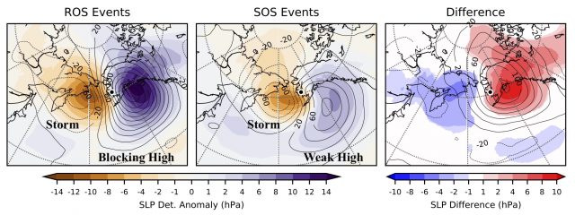
Figure 4: Detrended sea-level pressure anomalies (colored shading) and upper-level atmospheric height anomalies (contours) for (right) rain-on-snow events and (center) only snow-on-snow events and (right) their difference. The darker purple in the left-hand plot indicates that rain-on-snow events are accompanied by strong atmospheric blocking. This blocking forces storms north into the Bering Sea and (eventually) the Arctic Ocean. The lighter purple in the center plot shows weaker high pressure and no tendency for blocking. In these situations, storms can plow on through toward the Gulf of Alaska.