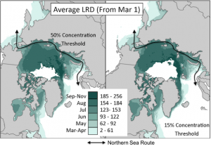
One of my active areas of research is trying to find physical links in the Arctic climate system that may help us better predict when seasonal sea ice cover will disappear each summer. Good sea ice predictions are important because shipping, tourism, resource extraction, and any other human activity in the Arctic Ocean is much more dangerous when sea ice is present. As the open water season gets longer (thanks to global warming), more shipping companies (like Maersk) are using the Northern Sea Route through the Arctic Ocean. The earlier we know when the sea ice will be gone and the waters open, the earlier we can plan shipping schedules.

The Northern Sea Route through the Arctic Ocean and the day sea ice concentration falls below 50% (left) or 15% (right).
A recently accepted article at the Journal of Geophysical Research: Atmospheres by myself and colleagues in Colorado and the UK describes how one physical link that can help predictions is when snow cover retreats in Siberia. More specifically, the paper focuses on how snow retreat in the West Siberian Plain (WSP) can help predictions of sea ice retreat over 1,200 km (over 700 miles) away in the southern Laptev Sea (SLS). It’s a complicated system of interactions, but here’s the short version:
1. When snow disappears from the West Siberian Plain (WSP), the land surface warms up quickly and releases substantial energy up to the atmosphere.
2. That energy generates waves in the atmospheres. Unlike waves in the ocean, which make swimmers and boats bob up and down, these waves oscillate north and south. When they first initiate, these waves look like a northward bulge or ridge on a map. The arrows below show the way winds blow when a wave occurs. Warm air moves north (red arrows) on the west side of the ridge and cold air moves south (blue arrows) on the east side. (This phenomenon of waves in the atmosphere is a big reason why temperatures vary so much in the Midwest, by the way.)
3. The geography of Siberia is special in being a huge swath of land without major impediments like the Rockies, Alps, or Greenland ice sheet. This allows the waves to easily migrate without breaking down. Therefore, as the waves build in late spring, they also shift eastward.
4. By June, the wave setup is fully formed, with the main ridge not over the initiation point, but rather the southern Laptev Sea. This means winds that blow from south to north over the Laptev Sea, carrying warm, moist air — air that is ideal for melting sea ice.
5. In this way, earlier snow retreat from the WSP means earlier wave generation in the atmosphere and earlier sea ice melt in the southern Laptev Sea.
This link isn’t the only thing that matters — it only explains around 1/3 of the variation of sea ice retreat in the Laptev Sea. However, for one variable in a complicated system like this, 1/3 is actually really helpful. Moreover, the snow typically disappears in the WSP in late April, and the sea ice doesn’t retreat from the southern Laptev Sea until late July — on average, there’s about 90 days in between. That’s a lot of planning time. For the interested parties, here’s a more detailed flow chart of the relationships being described in the paper:
Full Citation:
Crawford, A. D., Horvath, S., Stroeve, J., Balaji, R., & Serreze, M. C. (2018). Modulation of Sea Ice Melt Onset and Retreat in the Laptev Sea by the Timing of Snow Retreat in the West Siberian Plain. Journal of Geophysical Research: Atmospheres, 123. https://doi.org/10.1029/2018JD028697


Nice blog Alex and congratulations on the article – timely with the Maersk ship bypassing Eurasia to the North. What role, if any, do the Urals play? – does that N-S ridge focus the air flow in May and June-July? Or play a role physically perturbing airflow N-S or up/down? Thanks.
Hi Greg, that’s a good question. We didn’t dig too deep into how important the Urals are in the paper, but background knowledge tells us that the Urals do act similar to the Rockies in that west to east airflow is diverted north as the air rises over the mountains and then airflow is diverted south as the air descends. This encourages a ridge over the Urals (and a little west of the Urals) and a trough to the east of the Urals. In the climatology, there is a trough over the West Siberian Plain in upper-level airflow. In other words, because of the topography, the atmosphere already has a bit of a bias toward the sort of circulation that early snow retreat promotes. That can only help make this teleconnection happen between snow in the WSP and sea ice in the Laptev Sea.
That said, the Urals are, as I’m sure you know, much smaller than the Rockies — less than half as high and like 1/10 the width compared to the entire US part of the North American cordillera. So the impact is more muted compared to the Rockies, the bias less.
Nicely done, Alex. Congratulations on the paper!