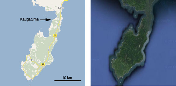
 KURESSAARE, ESTONIA–This country has had the historical misfortune to lie between the Russians to the east and the Germans to the west with all their imperial ambitions in the last few centuries. The terrain is deeply glaciated and thus has few natural defenses beyond thick forests, extensive bogs, and rocky coastlines. It has been occupied by Crusaders, Swedes and Polish-Lithuanians besides the multiple incursions of Germans and Russians. The 20th Century has been especially painful for Estonians.
Yesterday the Wooster Geology Estonia team worked near Kaugatuma on the proximal end of the Sõrve Peninsula on the southwestern tip of Saaremaa Island (see the images above). We then traveled south down the full length of the peninsula to Sääre. We visited a small, eccentric military museum and learned much about the history of this region. I think this strip of land is emblematic of the recent historical travails of Estonians — and thousands of Russians and Germans as well.
 This is a panoramic image looking from the top of an old Russian gun emplacement looking south to the end of the Sõrve Peninsula at the village of Sääre. For a larger view of this panorama, please visit the Sõrve Peninsula Wikipedia page. This peninsula, by the way, has only been connected to Saaremaa for about 2500 years. It and the other eastern Baltic islands are still rising from the sea as a consequence of post-glacial isostatic rebound.
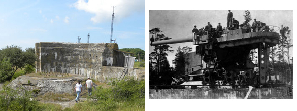
 On the left Rachel and Nick explore a massive concrete gun emplacement near Sääre. These were built by Imperial Russians to house the 12-inch guns shown on the right in a museum image. These guns commanded the western entrance to the Gulf of Riga. They were captured by the German Army in October 1917. Note that this was a World War I battle.
 The Soviets occupied and annexed Estonia in 1940 following the secret protocols of the earlier Molotov-Ribbentrop Pact. Nazi Germany declared war on the Soviet Union in June 1941, and in October turned its attention to conquering the Baltic islands. In November 1944, the Soviets returned and re-invaded Estonia and its islands. Some of the fiercest fighting took place in the Sõrve Peninsula in both invasions, as can be seen in the above maps photographed at the Kuressaare Castle Museum of Saaremaa. Note the November 1944 Russian amphibious landing at Kaugatuma. You can see why the Sõrve Peninsula has a significant number of landmines still remaining in the undeveloped forests. (Since 1999 there have been at least 77 casualties from landmines and unexploded ordnance in Estonia.)
 A Soviet artillery observation post (from the 315th Coast Guard Battery) disguised as a windmill. A nearby gun emplacement was connected to it through an underground bunker. The complex was captured by the Germans in the 1941 invasion. At the time, of course, there were far fewer trees.
 Foxholes dug by defending German troops on top of Kaugatuma Cliff in November 1944. As you can see from the map above, the Soviet amphibious landing was successful. On November 24th, against a direct order from Adolf Hitler, the Germans evacuated the Sõrve Peninsula and thus the last part of Estonia they held. The Soviets reported that up to 7000 German soldiers had been killed on Saaremaa, Hiiumaa, and Muhu islands during their offensive.
 Nick holds the rusted remains of a World War II artillery shell found near Sääre.
 The museum we visited was filled with objects collected from the World War I and World War II battlefields on the Sõrve Peninsula. This shelf of bullet-riddled German helmets was particularly poignant. There was a similar shelf of Soviet helmets.
 This is the text of a monument we found in the woods on the way to Sääre. It is the only such memorial I’ve seen here in all three languages of the combatants. (I could not find a way of editing out my own ghostly reflection.)
Without the old trenches, bunkers and decaying concrete fortifications, it would be hard to believe such violent events happened on these quiet islands. The occupations by the Nazis and Soviets had their own much more ghastly horrors as well, including mass executions, deportations and concentration camps. It is over now, though, and we can freely wander these beautiful shores and absorb ourselves in the arcane details of Silurian paleoecology while enjoying the flowers, butterflies and very friendly Estonian people. Here’s to peace and the vigilance to maintain it.


Pingback: Wooster Geologists » Blog Archive » A windy, windy day in the Cretaceous
I found this to be quite interesting. I had never heard of any of the battles that occurred in Estonia, nor either of Latvia or Lithunia. I have read much about WWI and WWII, I know of the Baltic states but had never read anything about the battles that took place there, this will probably lead me to search for and read more about these lesser known fronts of the European war. Thank you for the information, it was well received.
Thanks, Gary. I hope we’re all learning from this grim history.
These photos are fascinating of an area very few see where big things have occurred. Thanks, Mark. In an earlier war, off the coast of Zerel in the Straits of Irben the Russian destroyer Ochotnik was sunk by an aerial mine ( laid by the Germans ) on the 27th of September, 1917. The incident is regarded by many authorities as the first successful use of aerial minelaying.
Thank you very much, John. That is a fascinating addition to the history. You’re right — very few people visit the place, especially Americans. It was a privilege.
Hello,
I see the texts on this page are quite old, 8-9 years old, however, I have just watched “1944” from Director Elmo Nuganen, Starring Marko Leht, Magnus Mariuson, Maiken Schmidt, and was glad to learn something today that enriched my understanding of the History of that part of the world. Was inspired to google “what happened to the Germans on 11-19-1944 at Sorve Peninsula” and that’s how I came across your site. Thanks, Thomas
Thank you very much, Thomas. I also recently watched “1944” and was moved by the story and the setting. Thanks for taking the time to comment. Cheers, Mark