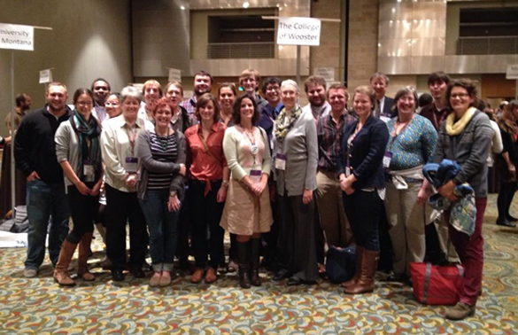
Friends of Sakurajima Volcano

KAGOSHIMA, JAPAN – To commemorate the 100th anniversary of the Sakurajima Taisho eruption, Kagoshima is hosting the Friends of Volcano Fair.

The fair is part of an outreach program at IAVCEI 2013 to increase awareness of volcanic hazards.

The fair is part of an outreach program at IAVCEI 2013 to increase awareness of volcanic hazards.

An over-sized 3-D relief map shows Sakurajima nestled snugly into Kagoshima Bay, emphasizing just how important volcanic hazards are to the people of Kagoshima.

An over-sized 3-D relief map shows Sakurajima nestled snugly into Kagoshima Bay, emphasizing just how important volcanic hazards are to the people of Kagoshima.

DSC04784Rhythmic thumping drew me out of the conference center to the front garden, where I was treated to a drum performance called Sakurajima Hinoshima Taiko, or Sakurajima Island Drums of Fire.

Here’s a video of the drums in action:

Although there can be negative health effects for those who live near volcanoes, the fair highlighted many of the positive aspects to having Sakurajima as a neighbor. A product display called The Blessings from Volcanoes featured products made from volcanic materials. Local companies are making soaps and other products that exploit the abrasive properties of ash. There were also some novel uses of shirasu (volcanic ejecta) that were new to me.

The tiles in the middle and on the right are made of ash, which are much lighter and more durable than the traditional concrete tile, shown on the left.

The tiles in the middle and on the right are made of ash, which are much lighter and more durable than the traditional concrete tile, shown on the left.

This shirasu greening base is an environmentally friendly landscapting option. It has excellent water retention properties, which allow it to be used to create green space on train tracks, rooftops, and in parking lots.

This shirasu greening base is an environmentally friendly landscapting option. It has excellent water retention properties, which can be used to create green space on train tracks, rooftops, and in parking lots.

Although the fair was focused on Sakurajima, it also offered an opportunity to highlight some of Kagoshima’s other attractions, like the aquarium.

At the aquarium booth, people had a chance to touch sea cucumbers, urchins, and hermit crabs.

At the aquarium booth, people had a chance to touch sea cucumbers, urchins, and hermit crabs. (FYI, sea cucumbers are soft and slimy).


Posted in Uncategorized | Tagged , , , , , | 1 Comment

Wooster’s Fossils of the Week: Dinosaur teeth from the Cretaceous of Morocco

Spinosaurus_aegyptiacus_Cenomanian_Alnif_Morocco_Tooth_052013The fossil above is the best of a collection of dinosaur teeth given to us by the generous George Chambers (’79). The species that held it is the gargantuan theropod predator Spinosaurus aegyptiacus Stromer, 1915. The teeth are from Cenomanian (Upper Cretaceous) rocks exposed near Alnif, Morocco.
Spinosaurus_Group052013Here are some more of our Spinosaurus aegyptiacus tooth collection. You can see that the teeth have been extensively repaired with plaster and epoxy. That’s fine for us because they’re the only dinosaur teeth we have!

(Reconstruction by Dimitry Bogdanov, Wikipedia)

(Reconstruction by Dimitry Bogdanov, Wikipedia)

Spinosaurus is surprisingly little known in the general public, at least until the Discovery Channel started making incredible videos about the extinct beast. It was the largest of all carnivorous dinosaurs yet discovered — even bigger than Tyrannosaurus, Allosaurus and Gigantosaurus. Some specimens were up to 18 meters long. Spinosaurus was characterized by long spines extending up from the vertebrae almost like a pelycosaur. Its head was like that of a crocodile — long and narrow. Its teeth, too, are like those of crocodiles and alligators, being blunt, rounded and strong rather than sleek and sharp. They probably crushed and shook their prey in a crocodilian way as shown in those amazing Discovery Channel videos.

The original specimen of Spinosaurus was discovered in Egypt in 1912. Those fossils were completely destroyed when Munich, Germany, was bombed in 1944 by the Royal Air Force. Since then a few other incomplete skeletons have been found, along with lots of teeth.
435px-Ernst_StromerSpinosaurus was found, described and named by Ernst Freiherr Stromer von Reichenbach (1870-1952), a German paleontologist and aristocrat. Stromer’s scientific odyssey is worthy of a movie and is the basis of an excellent book (The Lost Dinosaurs of Egypt). He began his paleontological work in Egypt in 1910 at a time tensions between the British and Germans were ramping up. He fought disease, weather extremes and bureaucratic delays to make his unexpected dinosaur discoveries. As just one example, his fossils actually arrived in Germany in 1922 — ten years after they were collected. (World War I only took up four of those years.) In his latter years he refused to join the Nazi Party and maintained relationships with Jewish friends. This may have led to the destruction of the Spinosaurus specimens because the Nazi director of the Munich museum refused to move the fossils to a safe location. In the end he outlived the Kaiser and the Führer, dying at the age of 82 in 1950. A tough paleontologist in a tough time.

References:

Amiot, R., Buffetaut, E., Lécuyer, C., Wang, X., Boudad, L., Ding, Z., … and Zhou, Z. 2010. Oxygen isotope evidence for semi-aquatic habits among spinosaurid theropods. Geology 38: 139-142.

Buffetaut, E. and Ouaja, M. 2002. A new specimen of Spinosaurus (Dinosauria, Theropoda) from the Lower Cretaceous of Tunisia, with remarks on the evolutionary history of the Spinosauridae. Bulletin de la Société géologique de France 173: 415-421.

Nothdurft, W. and Smith, J. 2002. The Lost Dinosaurs of Egypt. Random House, 242 pages.

Smith, J.B., Lamanna, M.C., Mayr, H. and Lacovara, K.J. 2006. New information regarding the holotype of Spinosaurus aegyptiacus Stromer, 1915. Journal of Paleontology 80: 400-406.

Posted in Uncategorized | Tagged , , , , | Leave a comment

Volcanoes! Volcanoes! Volcanoes!

KAGOSHIMA, JAPAN – The 2013 Scientific Assembly of IAVCEI, the International Association of Volcanology and Chemistry of the Earth’s Interior, has officially started in Kagoshima, Japan.

IAVCEI leaders and local welcome delegates from ~60 countries in today's opening ceremony.

IAVCEI leaders and local elected officials welcome delegates from ~60 countries in today’s opening ceremony.

The conference is a volcanologist’s dream, with sessions focused on every aspect of volcanology and a mid-conference field trip to Kagoshima’s own volcano, Sakurajima (currently at alert level 3). Day #1 didn’t disappoint. I’ve already co-chaired a session on Lava Flows with a fantastic group of international scientists and gave a talk on the dynamics of pillow-dominated subglacial eruptions recorded in Undirhlithar quarry on the Reykjanes Peninsula in southwest Iceland. You may remember that Lindsey Bowman (’12) and Becky Alcorn (’11) completed I.S. theses in Undirhlithar. Here are some highlights from our presentation:

Slide05

Undirhlithar quarry is a unique exposure that  provides insights into the internal architecture of a glaciovolcanic pillow ridge.

We've identified and mapped  pillow lavas, intrusions, and dikes.

Most of the quarry is made of pillow lavas, which are emplaced during effusive subaqueous eruption. We’ve also identified intrusions and dikes that feed the overlying pillow lava flows.

We've also identified tuff and tuff-breccia in the quarry.

There are also fragmental units in the quarry. The tuff, or fine ashy layers, probably represent periods of quiescence between eruptive events. The tuff-breccia, which has larger clasts, are formed during explosive activity and as a result of gravitational collapse along steep slopes.

Combined with geochemical and petrological variations, we've generated a model for how the units exposed in Undirhlithar were emplaced.

Combined with geochemical and petrological variations, we’ve generated a model for how the units exposed in Undirhlithar were emplaced that involves a complex sequence of multiple eruptive events.

The model involves a complex sequence of eruptive events under changing magmatic and eruptive conditions.

The sequence of events occurred under changing magmatic and eruptive conditions, which suggests that even small glaciovolcanic ridges can be constructed in a complicated manner.

Posted in Uncategorized | Tagged , , , , , , | 1 Comment

We must have walked 10 million miles.

Guest Blogger: Abby VanLeuven

June 26th: Marble Mountain

Our arrival at the southern end of Marble Mountain begun with the sighting of 3 orcas that as Dr. Wiles explained were a sign of good luck. Thus began the assent into the bug-infested shrubbery complete with thickets of devils club and raspberry bushes. We were trying to climb to 2000 ft. elevation set up camp and then climb 400 more ft., in order to reach the Mountain Hemlocks that we were going to core. We were trying to core these particular hemlocks -because they are part of a Nunatak forest. A nunatak forest is an island of forest that survived the ice sheet moving over the area because of its high elevation. These trees would have been great for my thesis because of their age and high elevation.

About an hour into our hike the sun was bearing down on us, it was 85 degrees out and we were out of water with no streams or snow melt in sight. As the elevation and incline rose so did our levels of dehydration, frustration and exhaustion and around hour 5 we made the executive decision to turn around. Although it was pretty disappointing not to be able to reach the trees we ultimately made the right decision because of the lack of snow melt. Two hours later after sliding, stumbling, and falling down the mountain all while dreaming about water we heard the sound of the river and stumbled into it chugging as much as we could.

It was quite the adventure and although we looked it in the eye, Marble Mountain still holds its mysteries.

1016123_10151677249508675_473350248_n


Marble Mountain is the peak on the far left.

1044718_10151677450203675_327465260_n


Andy and Dr. Wiles trying to climb up the limestone rock face with 30 pound backpacks (our only break from dense Devils club and other shrubbery).

1266_10151677316563675_1670294911_n

Distressed after descending Marble Mountain (10PM).

June 28th-30th: days after Marble Mountain

We were rescued from Marble a day early and decided to take some cores from excursion ridge. We cored Western Hemlock, Mountain Hemlock and lots of Shore Pine. Although Shore Pines can sometimes be hard to correlate well, they have recently been in decline for a variety of biotic reasons and we are going to see if there is any climate signal that can be related to their stress.

The first day back (28th) we went up to Yellowleg trail, a lower site on excursion ridge, and started coring Western Hemlock and some Shore Pine. The lower elevation part of the trail started out dominantly a Western Hemlock forest opening up to more Mountain Hemlock and then ending with a bog full of Shore Pine. At the end of the day we were hiking along the road and saw a quartz vein that had been folded ductilely, which was really cool to see after learning about in structure.

IMG_9323

View at the base of the Yellowlegs trail overlooking Bartlett cove bay and Pleasant Island.

1043862_10151677318588675_1363738019_n


Western Hemlock

1005709_10151677319003675_1266442770_n


Quartz Vein.

Our next two days we started coring more Shore Pines in the valley below Excursion Ridge and finished coring the Yellowlegs Trail. While coring the trees in the valley we encountered our first rainy day but we survived. These Shore Pines are younger than the ones we sampled the day before but hopefully they will still yield valuable data.

Screen shot 2013-07-16 at 1.52.28 PM

Bog at the top of the Yellowlegs trail.

Screen shot 2013-07-16 at 1.54.42 PM

Coring a Shore Pine at the Yellowlegs trail bog.

To end our time in Gustavus we were invited by the foresters to aid them in their rivalry softball game against the lodge. We were acting as cheerleaders to the game, until the 5th inning where, in only 2 innings Andy got a run, Jesse made a diving catch at shortstop, and then Andy, as catcher, proceeded to drop the throw to home plate that would have prevented the lodge from winning. We met some great people and were sad to leave but at the end of the game with Andy’s huge mistake it was probably for the best that we were leaving on the ferry the next day.

On Saturday we took the ferry back to Juneau and there our adventure ended with a flight back to the lower 48 the next morning. We looked it in the eye and what an adventure Alaska has been.

1013659_10151677318583675_749107785_nTeam Alaska on a rainy day at the gateway to Glacier Bay National Park and Preserve.

1004774_10151677324733675_1439840483_n


Team Alaska on a sunny day riding the ferry from Gustavus to Juneau.

Posted in Uncategorized | Tagged , , , , , | 1 Comment

We looked it in the eye

Guest Blogger: Andy Nash

Gustavus, AK. June 25, 2013 – As our research trip to Glacier Bay National Park and Preserve winds down we have some time to reconnect with the world and share some stories from our trip. The first half of our trip in the park was spent in Wachusett Inlet sampling logs and stumps that were killed during the advance of glaciers. Our group of Dr. Wiles, Jesse Wiles, Abby Vanlueven, and myself set up camp on June 19th on the south side of the inlet as close to Carroll Glacier as we could get. Our camp was next to an alluvial fan, which had a stream fed by snow melt running through it. This camp made the perfect home for our 5 day stay. We were lucky to get great weather our entire stay in Wachusett Inlet. The temperature ranged from 70-80° F and it only rained once at night while we were in Wachusett.

Andysmapfromvargo (2)

Our base map with daily tracks that show everywhere we hiked

Day 1

After camp was set up on day one the group kayaked and took a hike Northwest of the inlet and onto moraines formed recently by Carroll Glacier. This served as a way for us to get acclimated to the area and also to scout out potential sites for further investigation. On this hike we saw plenty of bear sign and moose activity but unfortunately we didn’t see either of the animals during our stay in Wachusett.

1048179_10200720241981965_1859654094_o

Our group: Abby Vanlueven ’14, Andy Nash ’14, Jesse Wiles (left to right) standing on Carroll Glacier’s ice-cored moraines

Day 2

On day two we sampled logs on the outwash plain to the north of Wachusett Inlet. This outwash comes from Cushing and Burroughs Glacier which are located north of Wachusett and Carroll Glacier. I described the stratigraphy of this valley cut by outwash as well as collecting core samples from detridal logs. As we hiked around this outwash plane we came across some birds that were not pleased with how close we were to their nests. They were relentless in protecting their eggs, swooping in from all angles and diving right at our heads. They only stopped when we retreated back to our kayaks. We finished off our day by running up two valleys on either side of the inlet to see if the river had eroded away any sub-fossil wood.

1053077_10200720242501978_1077456222_o

The valley north of Wachusett Inlet which was once the site of an ice dammed lake (1960s) and is now being cut down by glacial outwash streams

1025880_10200720242741984_1938639531_o

Coring a log in the valley

977297_10200720244382025_1115015604_o

Our group’s typical reaction to bird attacks

Day 3

Day three of our Wachusett Inlet adventure might be the most painful day for me to recount. I don’t think I will ever forget June 21, 2013. We didn’t realize until after that our longest day also coincided with the summer solstice. One this day we hiked from Wachusett Inlet to Queen Inlet by crossing over the glacial moraines we hiked up on day one. What was different on this day was the discovery that some of these glacial features had remnant ice under their slopes. This made for some interesting scrambles up slippery sand covered ice slopes, lots of frustration, and assistance from the ice ax. We estimated that after 6 hours and about 9 miles of tough hiking, we finally reached Queen Inlet. The outwash plane was massive, about 1 mile wide and 2 miles long. For all of that work we were rewarded with cores from 4 samples. Luckily the great views and feeling of invincibility we got after completing that hike overcame the soreness and fatigue when we woke up the next day.

977017_10200720245102043_17681221_o

One of the two naps we took in Queen Inlet

1048776_10200720250062167_1182127828_o

Searching for logs to sample

Day 4

After our expedition the previous day we all agreed that day four would be a recovery day. We took a little paddle down the inlet to core logs brought down to alluvial fans by streams much like the one we camped at. Today ended up being our most productive day. In total we sampled over 25 trees and took more than 40 cores. We called it an early day and went back to camp to play some cards which proved difficult with the wind and the bugs.

1053219_10200720251782210_5514480_o

Abby and I extracting cores from a hemlock log

Day 5

Our final full day in Wachusett Inlet was dedicating to cover the last bit of ground that we hadn’t covered in the previous four days. We hiked back up to the moraines but turned north away from Queen Inlet (Thankfully). Our attempt was to go back to the outwash plain from day two and sample from the western side which was blocked off by a river. We soon learned that out effort were all for not as another outwash river came off of Carroll Glacier creating a wedge of inaccessible land between the two rivers. This was disappointing because I had hoped to describe the stratigraphy of this valley wall which was exposed a little bit better than the other side.

1040074_10200720254022266_600085073_o

Nobody was safe from the mud on our last day. Abby had a tough time not getting stuck


We decided that the only motto that was appropriate for our trip to Wachusett Inlet was, “We looked it in the eye.” We covered every area at the head of Wachusett Inlet where sub-fossil logs could have been found. Our adventure in Wachusett might have come to an end but we still have more to report on as we spend some time on Marble Mountain and in Gustavus with plans to core living trees now. Be sure to watch for the next post from Abby about our further travels in Alaska.

Posted in Uncategorized | Tagged , , , , , | 1 Comment

Wooster’s Fossils of the Week: Dinosaur footprints of unknown provenance

DinosaurFootprintConcaveEpireliefThese are the only fossils in the Wooster collection I feel some shame about. They are tridactyl theropod dinosaur footprints. They are not spectacular, but they do the job for classes and visits by schoolchildren. I regret that we have them, frankly, because it means at some time in the distant past (well before me) someone chopped them out of a red sandstone, losing in the process all context including location and age. Footprints like these are most valuable, both scientifically and aesthetically, in their original places alongside the rest of the trackway. Now I can only guess that these footprints came from the Jurassic of the southwest, probably Arizona or Utah.

At least we can use them for some trace fossil terminology. (A trace fossil is evidence of organism behavior, such as a trail, burrow, boring or scratch marks.) The top image is what we expect from a fossil footprint: an indentation in the top of the sandy bed now turned to stone. It extends into the rock and is on the surface, so we call it a concave epirelief. (“Epi-” means surface.) The footprint below is also of a three-toed theropod dinosaur, but it extends out of the rock and is on the underside of the bed. We thus call it convex hyporelief. (“Hypo-” means underneath.)
DinosaurFootprintConvexHyporelief

WaterFilledFootprintOne quick way to see the outlines of an indistinct footprint is to fill a concave epirelief with water, as above. This provides much more contrast.
WilsonBoysFootprintThis is how dinosaur footprints should be appreciated: in the field as part of trackways. The kids above are three of my brothers a long, long time ago. I think this is near Tuba City, Arizona, and these are Jurassic theropod footprints like the Wooster specimens. Note that to increase contrast the footprint is filled with … let’s just say “water”.

References:

Miller, W.E., Britt, B.B. and Stadtman, K. 1989. Tridactyl tracks from the Moenave Formation of southwestern Utah (pp. 209-215). Gillette, D.D., and Lockley, M..G, eds., Dinosaur tracks and traces: Cambridge, Cambridge University Press.

Posted in Uncategorized | Tagged , , | 1 Comment

An ancient Nabatean, Roman and Byzantine city in the northern Negev

MamshitGuardhouseMansion071213MITZPE RAMON, ISRAEL–Our final stop of the final day: Mamshit. Above you see some of the ruins of this city east of Dimona and a short distance west of the descent into the Dead Sea Rift Valley. The highest structure is the “guardhouse” (which overlooked a reservoir) and the lower on the right is known as “the wealthy house”. All the other rocks you see are remnants of mostly homes and other dwellings.

Mamshit was established by the Nabateans as a station along the Incense Route around 50 CE. Most of the primary buildings were constructed in the Second Century after the Nabatean Kingdom became part of the Roman Empire. As a trading city it flourished until the Seventh Century when either the Persian (614 CE) or the Arab Invasion (636 CE) ended its importance and it faded away. Today we toured it for about an hour and we were the only people there.

MamshitDam071213From the Guardhouse one of the three Mamshit dams comes into view. These were the most critical structures in the settlement because they captured the winter runoff in reservoirs that could be used throughout the dry summers. The area behind this dam is now completely silted up. There was a British police post at this site in the 1930s and 1940s running a series of patrols on camels. The Brits rebuilt the dam for their own use.

MamshitWesternChurch071213This is a lavish church (the “western church” or “Church of St. Nilus”) in Mamshit. Beautiful mosaics are still preserved on the floors.

MamshitStudentsExploring071213The Wooster students are her exploring one of the grander houses built in the Second Century.

MamshitDoorways071213Steph and Lizzie are using the doorways to estimate the likely heights of the residents. Looks like they were more Lizzie size than Steph!

This was a suitable place to end the Team Israel 2013 expedition: a location where geology, archaeology, history and culture are combined in ruins still open for interpretation and study. Now we have one more night before departing early in the morning for the airport in Tel Aviv. We appreciate this opportunity for travel and research very much!

Posted in Uncategorized | Tagged , , | Leave a comment

Wooster Geologists in the Dead Sea

LizzieStephDeadSea071213MITZPE RAMON, ISRAEL–The Wooster Geologists in Israel spent their last full day in the country visiting the Dead Sea Rift Valley and an archaeological site. It feels very good to have packed our hiking boots away for the season. Above, of course, is Lizzie Reinthal and Steph Bosch floating in the hypersaline waters of the Dead Sea at an almost deserted Ein Gedi beach. The surface of the water here is at -427 meters, or about 1400 feet below sealevel, making it the lowest point on land. The water Lizzie and Steph are floating in is 8.6 times saltier than typical seawater. This means I don’t have to worry about anyone drowning here. (Swallowing the water and getting it in eyes and ears is another story!)

OscarDeadSea071213Oscar Mmari was there as well. His style was a bit more relaxed. He was no doubt pondering that the amount of bromine in these waters (at 4.2 g/kg) is the highest anywhere on Earth.

SodomSaltStudents071213On the way to Ein Gedi we stopped by the famous Mount Sodom — a mountain of salt. This is a famous salt diapir, or a salt dome that has reached the surface. The layers of salt here are vertical because of deformation caused by the upward movement of the material. The salt, mostly halite, moves up because it is less dense and more plastic than the overlying sediments.

SodomSalt071213This is a close view of the salt layers. It is very difficult to distinguish original sedimentary layers from planes developed by shear stress.

LotWifeSodomSalt071213The spot we briefly explored is underneath a jointed block of salt referred to as “Lot’s Wife”. Remember her? In Genesis she looked back at the destruction of Sodom and was turned into a pillar of salt. If this is her she was about 60 feet tall.


Posted in Uncategorized | Tagged , | Leave a comment

Last day of fieldwork for Team Israel 2013

1_DragFoldOscar071113MITZPE RAMON, ISRAEL–We like to think that Dr. Shelley Judge would be proud of our fieldwork today. The Wooster Geologists returned to Wadi Hawarim to finish our fieldwork for Oscar Mmari’s project on synsedimentary faulting in the Mishash Formation (Campanian, Upper Cretaceous). We returned to the fault visible above just to the left of the dark outcrop of the lower Mishash. The left side is upthrown, the right downthrown, making this a very steep normal fault. the Mishash seen here is in a magnificent drag fold against the fault. The Mishash is eroded away on the upthrown block, so we could only climb to the top of the hill here and estimate the minimum displacement on the fault. The blocks are separated by at least 50 meters. The fault trace is almost exactly east-west. You can barely see Oscar in the lower right standing on the spot where the Mishash rocks fold more than 90° to become horizontal to the right. Oscar and I worked today to follow the fate of a conglomerate that is thickest at the fault where Oscar is standing (location 031 on the image at the end of this post), and then thins and becomes finer as we move away from the fault into the syncline to the south. We believe this indicates that the conglomerate came from the upthrown block and thus the fault formed while the Mishash was being deposited. (Lizzie Reinthal and Steph Bosch, in the meantime, collected more shark’s teeth for us and then explored the wadi system.)

2_HawarimPhosphorites071113This is the Mishash Formation phosphorite zone several hundred meters south of the fault (location 049 in the bottom image). It is much thicker than the section near the fault (see the top photo in this entry).

3_ThinConglomerates071113The conglomerate that is a meter thick near the fault is reduced to these two lensoidal coarse sandstones that Oscar found in this southernmost outcrop. The grain size and thickness reduces dramatically as we move away from the fault.

4_WadiHawarimSection071113This beautiful Wadi Hawarim section of the phosphorites gave us our final clues as to the relationship between the fault and the conglomerate. We also have a sealevel story here with shrimp burrows, but we’ll save that for a later post after Oscar has done some lab work.

5_Hawarim071113Here is a Google Earth view of Oscar’s collecting sites and measured sections. The fault shown in the top photo is at 031, with the photo taken from 047. The fault runs east-west, and Oscar’s sites are all to the south.


Posted in Uncategorized | Tagged , , , | Leave a comment

Meeting a group of excellent young Israeli geologists

OlympiadStudents071113MITZPE RAMON, ISRAEL–Today I had the pleasure of talking with four excellent Israeli students who form their nation’s team in the upcoming 7th International Earth Science Olympiad. Their advisor and coach, Hanan Ginat (on the far right), invited me to speak to these young adults about paleontology as they study for the competition to be held in India this September. I was amazed at how hard these students are working for this event, and how much will be required of them during the Olympiad. They will have ten days of tests and practical exercises. In past events these contests have included interpreting core samples, assessing building stones, and even planning dam sites. In the written tests there are questions not only about geology and paleontology, but also oceanography, atmospheric sciences, and astronomy. Wow. Most of it in English, too.

The students had excellent questions and quickly responded to puzzles about various fossil specimens you can see scattered on the table above. It was so much fun — the time just flew by. Good luck to them in the tournament and in their future endeavors. These are very bright students who know the value of learning and persistence.

Posted in Uncategorized | Tagged , , | Leave a comment