Another gorgeous day on the Yorkshire coast

Dismantled pillbox Filey BeachSCARBOROUGH, ENGLAND (June 10, 2015) — We certainly can’t complain about the weather for our fieldwork in Yorkshire this year. Today was spectacular with blue skies and cool sea breezes. It made the long beach hikes very pleasant.
1 Mae on Speeton 061015This was our first day without our English colleague (and Yorkshire native) Paul Taylor, so we were on our own for transportation. We figured out the bus system, though, and made it to the Lower Cretaceous Speeton Clay at Reighton Sands in good time. Here is the last view you’ll have of Mae Kemsley (’16) working on her outcrops of this gray, mushy unit. We collected sediment samples this morning, along with a few last fossils.

2 Meredith on Speeton 061015Here is Meredith Mann (’16) doing the same. We finished all of our fieldwork for Mae’s project by 10:30 a.m., so we could make a long beach hike from the Speeton Cliffs northwards to Filey.

3 Meredith waiting on tide

4 Mae waiting on tideWe hiked as far as we could on Filey Brigg, but had to chill because our sites were still cut off by the high tide. Waiting for a tide to drop is tedious, but the students had plenty of patience.

5 Thalassinoides 061015We reached the large slabs of Hambleton Oolite Member (Upper Jurassic, Oxfordian) with Thalassinoides burrows to begin Meredith’s data collection. These are impressive trace fossils, with numerous shelly fossils in the surrounding matrix. We took reference photos and collected what we could. Unfortunately only three slabs met our criteria for measurements, so we moved to a unit exposed just below the Hambleton.

6 Cannonball concretionsOn the north side of Filey Brigg there are these large “cannonball” concretions, which were excellent stratigraphic markers for us. They are in the Saintoft Member of the Lower Calcareous Grit Formation. They told us that the units above were the Passage Beds Member of the Coralline Oolite Formation.

7 Passage Beds 061015Mae and Meredith are here collected fossils from the Passage Beds above the concretions. This unit is interesting to us because it contains shelly debris that was apparently washed onto shore during storms. These shells are often heavily encrusted with oysters and serpulids. Such sclerobionts have been little studied in this part of the section.

8 MMbus 061015On our sunny ride home the students sat in the front of the top section of our double-decker bus. Not a bad commute for a day’s work!


Posted in Uncategorized | Tagged , , , , , | Leave a comment

Russian Birch Climate Reconstruction

Guest blogger – Dan Misinay

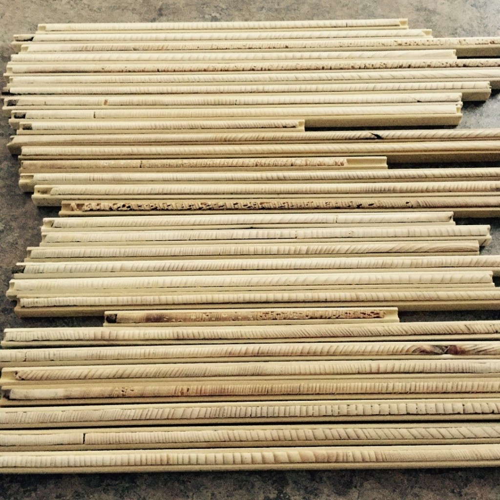
During the summer of 2014 Dr. Wiles and I.S. student Sarah Fredrick traveled to Kamchatka, Russia. While there, they cored hundreds of birch (Bertula ermanii) and larch (Larix gmelinii) trees to bring back to the tree ring lab and be analyzed. The cores were mounted, sanded, counted, and measured. This study is important because very little work has been done with Russian birch regarding climate reconstruction. The work that I have been doing so far this summer has been strictly with the birch trees.

DSCN1084a

Hard at work with COFECHA and measuring cores.

IMG_1400a

The birch forest growing on steep slopes in Kamchatka.

Image_2041

Photo of sample UG05 of normal growth rings in the birch.

Image_2038

Rapid growth occurring in 90 percent of the samples. Possibly caused from warming or increased precipitation.

Image_2037

One of the many challenges with the birch trees were these patches of narrow rings. This growth occurred from 1990-2013 and or 1930-1960 in many of the cores. This growth could be caused from climate change or pollution in the surrounding environment. Additionally the rings at this site may be reacting to being on a slope, or the tree is slowly dying.

Image_2043

Birch with small rings, notice one of the rings is much lighter than the rest of the wood. These changes occur between 1825 and 1875 in some of the samples.

IMG_1403a

Another photo of birch trees growing in Kamchatka. Some of the abnormal ring growth could be linked to the growing conditions. Trees the grow on slopes generally have reaction wood which will cause the ring to grow much larger on side of the tree than the other. The side opposite of the reaction wood is generally very narrow and rings are pinched out.


ug vs sono

UG site from Kamchatka plotted against results from Sano et al, 2009. These are raw ring width measurements correlated with one another. UG site measurements are represented by the green line and Sano’s data is the blue line.

STD PLOTn

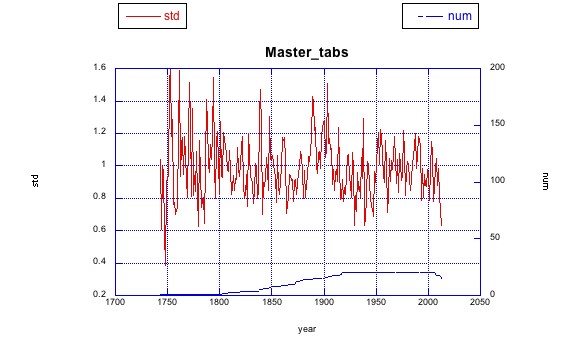
The above graph is the UG site chronology after being standardized. The growth trend is removed so that the desired climate signal is only showing. There are many trends through out the graphed that will be addressed later in the summer when the climate reconstruction is completed. The blue line on the bottom represents the number of samples at each given year.

References

Sano, M., Furuta, F., and Sweda, T., 2009, Tree-ring-width chronology of Larix gmelinii as an indicator of changes in early summer temperature in east-central Kamchatka: J For Res, v. 14, p. 147-154.

Posted in Uncategorized | 1 Comment

A coincidence?

a Shoe Zone SmithSCARBOROUGH, ENGLAND (June 9, 2015) — Why do these geologists look so pleased to be standing in front of a nondescript shoe store? The answer is on the blue plaque above their heads.

b Smith plaque 060915Turns out we’ve been eating breakfast every morning next to the Scarborough home of the heroic geologist William Smith. Auspicious!

Posted in Uncategorized | Tagged , , , | Leave a comment

Return to the Speeton Clay

1 Mae on Speeton 060915SCARBOROUGH, ENGLAND (June 9, 2015) — Team Yorkshire returned to the Speeton Clay today to begin the fieldwork for Mae Kemsley’s Senior Independent Study project. Mae chose to work on the incredible diversity of belemnites found in this Lower Cretaceous unit. There are two aspects to her study: the paleoecology of the belemnites themselves, and the taphonomy of their distinctive bullet-shaped calcitic rostra (guards). We hope that Mae will be able to do some stable isotope work to help elucidate the paleoenvironments these pelagic creatures lived in. Oxygen isotopes in particular may indicate the seawater temperatures when the belemnites were forming their skeletons. The Speeton Clay has faunas from alternating Boreal (northern, colder) and Tethyan (southern) regions, so this will be interesting.

2 Middle Cliff SpeetonHere is the Speeton Clay forming the Middle Cliff along the shoreline. Virtually every outcrop of this unit is slumped from above, so sorting out the stratigraphy is a challenge.

3 Mae working 060915Here is Mae again working through a small patch of the Speeton Clay. There are four broad intervals of the unit (A, B, C, D) that we must recognize by the fossil content and the position of the outcrop relative to various field markers like abandoned pillboxes, breakwaters, and large rocks.5-SS-Laura-boilers

One of our intertidal landmarks is a set of boilers from the 1897 wreck of the SS Laura, an Austro-Hungarian cargo ship that ran aground near Filey Brigg. The heavy boilers have stayed in essentially the same place for over a century.

4 Speeton work 060915The weather could not have been better today. We got Mae’s project off to a fine start with several sets of samples collected from the four primary units of the Speeton Clay.

Paul Taylor returned to his home in Epsom at the end of the day, leaving the three Americans to their own devices. He was essential in our first week, getting us oriented to the local geology, expertly driving us around to the various sites, and entertaining us with his trademark puns. He trained us well to carry on into week two of the Yorkshire Expedition.

Posted in Uncategorized | Tagged , , , | Leave a comment

Team Yorkshire chooses projects

5 Meredith on block 060815SCARBOROUGH, ENGLAND (June 8, 2015) — When we do field Independent Study projects in the Wooster Geology Department, we never know the exact topic until we’ve tested ideas on the actual outcrops. Today we did the last of our general exploration, and then at lunch Meredith Mann (’16) and Mae Kemsley (’16) decided on what they wanted to do for their projects. Meredith chose to study the fossil community associated with Thalassinoides trace fossils in the Birdsall Calcareous Grit Member of the Coralline Oolite Formation (Upper Jurassic, Oxfordian) at Filey Brigg. She’s shown above on one of the exposed bedding planes she will soon be examining in detail. Mae’s choice? You’ll read it here tomorrow.

1 Cayton Bay 060815We started our day in Cayton Bay, south of Scarborough. We had a long walk at high tide from our car south along the coast. After we hit the boulders in the middle of the view above, we saw no one else for the rest of the morning. The cliff is capped by Oxfordian limestones, with the thick Oxford Clay beneath. We had a few drops of rain while in Cayton Bay, but they didn’t develop into more than a sprinkle.

2 Kellaways rockWe couldn’t cross the boulder field (boulders and steep slopes are a theme of this expedition) until the tide receded a bit, so we spent some time examining this cliff exposure of the Osgodby Formation (Middle Jurassic, Callovian).

3 Gristhorpe BayWe crossed over Yons Nab (you just have to love these English place names) into Gristhorpe Bay to the south. Again, no other souls on this sunny day. After a quiet lunch, we retraced our route back to the car. The general reconnaissance is done. Time to start our work.

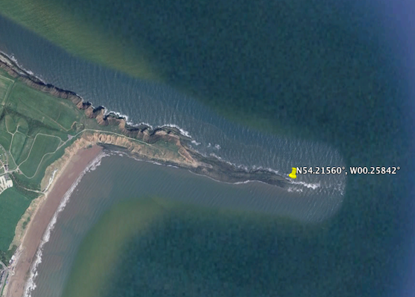
4 Filey Brigg 585 070815Back to Filey Brigg. This is a view down the axis of the Brigg as it enters the sea. Note what a spectacular day it is.

6 Meredith outcrop 060815Our job this afternoon was to work out the protocols of Meredith’s research, and pick her work sites. This is a beautiful exposure of the Birdsall Calcareous Grit Member on the north side of Filey Brigg. Note the Thalassinoides in place above Meredith. Meredith will be measuring and describing a section of the units here, and doing her mapping and collecting on the loose block along the Brigg itself.

Tomorrow we start Mae’s project!

Posted in Uncategorized | Tagged , , , , | Leave a comment

Shore defenses

a Beached pillbox closerSCARBOROUGH, ENGLAND (June 8, 2015) — We see many of these World War II concrete defenses along the Yorkshire coastline. This is a pillbox that was likely constructed in 1940 to defend the realm from the Germans. Of course, it was not placed on the sandy beach but up on the steep slopes overlooking the shore. Erosion of that headland since 1940 was complete, leaving this structure on the open beach.

b Slumped pillbox 060815It is a dilemma, building on these sea cliffs of the northern Yorkshire coast. The substrate here is a “boulder clay”, a Pleistocene glacial deposit known as a diamictite. It is easy to excavate, but flows readily under weight and when wet. The sea hammers away at the foot of these soft cliffs as their tops slump downwards. The heavy concrete gun emplacements and observation posts serve their purpose for a few years, and then eventually fall into the sea as the coast retreats. Seventy-five years of coastal erosion has removed a great deal of the cliffs.

c Destroyed pilbox 060815

Beached pillbox 061015

Dismantled pillbox Filey Beach

House with erosion problemGiven what you’ve seen above, would you buy this seaside house?


Posted in Uncategorized | Tagged , , , , | Leave a comment

Speeton Cliffs and Filey Brigg on a fine English summer day

1 Speeton 060715SCARBOROUGH, ENGLAND (June 7, 2015) — This steep and muddy slope may not look like much, but it is the man exposure of the famous Speeton Clay, a Lower Cretaceous unit rich with fossils. Team Yorkshire started here (N 54.16654°, W 00.24567°) this morning to continue our reconnaissance of the local geology. The weather could not have been better. (I can only imagine what this sediment is like when wet!)

2 Slumped Speeton Pillbox 060715The Speeton Clay is quite mobile, with slips and land slippages very common along its coastal exposure. This is a World War II pillbox, part of the sea defenses of Britain, making its way down slope on the clay. On the shore itself are bits of previous WWII concrete installations that are now on the beach.

3 Red ChalkAfter collecting dozens of belemnites from the Speeton Clay for future research, we visited an exposure of the Red Chalk (Hunstanton Formation), which has smaller belemnites of a different genus.

4 Chalk cliffs s SpeetonIf we continued to the south we would have met these imposing cliffs of chalk, the northern part of the series of white coastal chalks that extends south past Dover. Seabirds swirled around them in the thousands this morning.

5 Paul marine tutorialWhile walking back to our car, Paul Taylor showed Meredith Mann and Mae Kemsley various intertidal organisms exposed on the broad beach beneath the Speeton Cliffs.

6 Barnacle covered boulder SpeetonAt a certain mid-tide level, the boulders on the beach were entirely covered with tiny barnacles. The rock itself is completely hidden.

7 Barnacles limpets SpeetonHere is a closer view of the rock surface. The oldest barnacles are greenish, the younger are gray. You can easily see several small limpets, but do you see the three large individuals in the center? They are camouflaged by their covering of barnacles.

8 Speeton cliffs beachFor a Sunday afternoon on such a nice day, we were pleased to see very few people on large stretches of the beach along the Speeton Cliffs. We had much more company later in the day.

9 Hambleton oolite south 060715In the afternoon we visited Filey Brigg for a look at parts of the Coralline Oolite Formation (Upper Jurassic, Oxfordian; N 54.21674°, W 00.26922°). We found the Hambleton Oolite Member very accessible and with a good number of fossils that could be collected. We are here looking at the “Upper Leaf” of the unit.

10 Thalassinoides sediment 060715Down on the Brigg itself we saw these massive overturned boulders of the Birdsall Calcareous Grit Member with spectacular examples of the trace fossil “boxwork” Thalassinoides. These fossil burrow systems were made by shrimp, probably of the callianassid variety.

11 Thalassinoides full relief 060715Sometimes the sediment between the infilled Thalassinoides tunnels was washed away, leaving this beautiful network in full relief.

12 Hambleton Oolite north 060715On the north side of Filey Brigg we could continue to follow the Upper Leaf of the Hambleton Oolite Member. The exposure is very good and well above the high tide. The access to this place, though, requires a low tide like we had this afternoon.

13 Hambleton Oolite Lower Leaf 060715At this site on the north side of Filey Brigg (N 54.21823°, W 00.26908°) we can get to the Lower Leaf of the Hambleton Oolite Member, with the Birdsall Calcareous Grit Member just above. Again, the Hambleton has many fossils that can be collected. If you look at the undersurface of the yellowish rock above our field party, you may be able to make out the Thalassinoides trace fossils. We can thus place the loose blocks with this distinctive trace fossil in their original stratigraphic position.

Another delightful field day. One more expedition tomorrow, and then we decide on the specific student projects.


Posted in Uncategorized | Tagged , , , , , | Leave a comment

Exploring the coast north of Scarborough

Hundale Point section 060615SCARBOROUGH, ENGLAND (June 6, 2015) — Today Team Yorkshire got an early start this morning examining the Jurassic sections along the coast north of Scarborough. With Paul Taylor as our skilled English driver, we took the rental vehicle first to the village of Cloughton and then towards the coast for a hike to Hundale Point (above; N 54.33877°, W 00.42339°). There we exploring this beautiful section of the Scarborough Formation (Middle Jurassic, Bajocian) exposed as a cliff and wave-cut platform.

Bouldering 060615The day did not start easy. Our first attempt to get to the Point involved a long scramble over boulders at the bottom of the seacliffs. This is not my favorite kind of hiking as every step involves a decision about the stability and slipperiness of the next boulder. Note the slimy green algae on some surfaces. This was, though, a good introduction to various sedimentary features in the nonmarine portions of the Middle Jurassic section here. These rocks are important because they host petroleum under the North Sea.

Meredith Mae Hundale 060615Here we found one member of the Scarborough, the Spindle Thorn Limestone, to have lots of shelly fossils, including bivalves, gastropods, brachiopods, serpulids, belemnites and crinoids. They are relatively easy to extract from the matrix.

Hundale traces 060615Below the Spindle Thorn Limestone Member is the Hundale Sandstone Member. It has a fantastic suite of trace fossils exposed on the surface of the wave-cut platform. Here we see Thalassinoides (the large branching trace) and Planolites (unbranching smaller cylinders).

Hundale limpetsA great thing about working on a rocky seacoast is that a living hard substrate fauna is easily visible. Here’s a fun set of limpets and tiny barnacles at Hundale Point.

Robin Hood BayOur lunch stop was at Robin Hood’s Bay (N 54.41782°, W 00.52501°), which we accessed by way of Stoupe Beck. We briefly explored the Redcar Mudstone Formation (Lower Jurassic, Hettangian) on a rocky platform at low tide. Near the cliff we saw some trace fossils and a few lonely shelly fossils.

Whitby ammoniteWe ended our geological explorations of the day at Whitby, where we again examined a rocky wave-cut platform. We found numerous ammonites (like the one above), belemnites, and nuculid bivalves in the Whitby Mudstone Formation (Lower Jurassic, Toarcian). After our work on this very, very windy day, we headed into Whitby for ice creams and a look around the sites.

Whitby abbeyThe ruins of the Whitby Abbey are iconic for the region. They are high on a hill overlooking the city and the sea. This has been a set of ruins since the time of Henry VIII.

Hilda ammonites WhitbyPaul took us to a monument to local saints, including Saint Hilda (614-680), shown above. She was said to have turned the region’s snakes to stone, which you can see above at her feet. Those snakes better look very familiar to you!

Snake ammoniteTo enhance the ammonites-as-petrified-snakes legend, 19th Century craftsmen often carved snake heads onto ammonites. This specimen is in the Whitby Museum.

We learned a lot today. Paul even got to see a section new to him, the one at Hundale Point. Mae and Meredith have seen some project possibilities. Tomorrow we visit sections south of Scarborough. Note from our photos that we had sunny skies. The winds, though, were fierce!


Posted in Uncategorized | Tagged , , , , | Leave a comment

Team Yorkshire explores Scarborough

1 Scarborough060515SCARBOROUGH, ENGLAND (June 5) — It was a spectacular day on the coast of northeastern England. When Paul Taylor arrived by train at 10:30 this morning, the clouds broke and the sunlight streamed through. Mae and Meredith explored Scarborough in the morning, plotting out where the stores and other useful places are, and Paul and I began to sort through geological action plans.

2 Peter Rawson Paul TaylorPeter Rawson, on the left with Paul Taylor, joined us for lunch to give us local field advice. He is the senior author of the Geologists’ Association’s Guide to the Yorkshire Coast, so there was no one better to have as an advisor. We had lunch in one of the classic spa buildings and made our field plans for the next few days.

Rotunda Museum frontAfter lunch we visited the Rotunda Museum (above), which is devoted to the geology of the area. It was built in 1829 out of the Jurassic Hackness stone. William “Strata” Smith suggested the unusual design, and much of the museum is devoted to his accomplishments and legacy.

4 Rotunda Interior 060515Paul, Mae and Meredith are examining the upper levels inside the circular Rotunda Museum.

5 Smith stratigraphy RotundaThe motif around the rim of the main room in the Rotunda is the 19th Century version of the local stratigraphy, including some places we will be visiting tomorrow.

6 Smith fossils RotundaMany of William Smith’s original fossils (loaned by the Natural History Museum) are on display.

7 Smith figureWe could in several cases match the specimens with Smith’s illustrations of them.

8 Trap inspectionAfterwards we went down to the marina and inspected the crab and fish traps sitting on the wharves. What were we looking for?

9 Electra pilosa PDTBryozoans, of course! Here is an Electra pilosa, the most common species. (Photo by Paul Taylor.) We also saw many serpulids, barnacles, oysters and other sclerobionts. A good view of the present to inform our coming interpretations of past hard substrate communities.

10 Anne Bronte gravestoneFor a cultural interlude we visited the grave of Anne Brontë in the castle church cemetery. The sandstone markers are exfoliating, with most now unreadable. (Choose granite!)

11 Scarborough Castle 060515We walked up to Scarborough Castle and will explore it later when we have the chance. There are 3000 years of human history here. In 1914 it was heavily shelled by — you guessed it — the German Navy.

12 Scarborough downtown 060515In the evening it was back to the busy downtown for a seafood dinner. Our plans are in place, the context is set. Tomorrow we start our fieldwork.


Posted in Uncategorized | Tagged , , , , | Leave a comment

Wooster’s Fossil of the Week: A chaetetid demosponge from the Upper Carboniferous of southern Nevada

1 Chaetetid Bird Spring Upper Carboniferous Nevada 585I collected this lump of a specimen during my dissertation research in the Bird Spring Formation (Carboniferous-Permian) of southern Nevada. It was found in a richly-fossiliferous Upper Carboniferous (Moscovian) portion near Mountain Springs Pass, which is about 40 km southwest of Las Vegas. It is a chaetetid, which at the time I interpreted conventionally as a singular extinct sponge in the genus “Chaetetes“. Since then we’ve learned a lot more about chaetetids. (And about the stratigraphy of the Bird Spring Formation. I wish we had sequence stratigraphy way back then!)
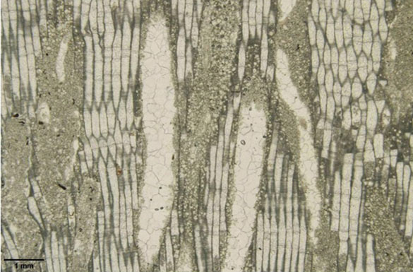
2 Chaetetid Bird Spring closer Upper Carboniferous Nevada 585Excellent and thorough work, especially by Ron West, has shown that the chaetetids are “hyper-calcified” members of the Class Demospongiae of the Phylum Porifera. They are sponges indeed, but the tubular chaetetid skeleton is found in at least three orders of the demosponges, including living ones. The chaetetid skeleton, which consists of very thin tubes (as shown above) is polyphyletic, meaning several groups of organisms converged on the same form.
3 Chaetetid Bird Spring closest 585In this oblique section of a chaetetid you can see the calcitic tubules, somewhat blurred by recrystallization.
4 Chaetetid Bird Spring cross-section Upper Carboniferous Nevada 585Here is a cross-section through one of the Bird Spring chaetetids. The tubules are very thin and long, somewhat resembling hair. Chaeto– comes from the Greek chaite for “hair or hairy”.

Now we know from systematic studies that the fossil “chaetetids” cannot be classified from their tubular skeletons alone. Without evidence of the spicules (which are rarely found, or at least recognized) and original mineralogy of the skeleton (many are recrystallized or, like the one at the top of this entry, replaced with silica) we can only refer to skeletal specimens such as ours as “chaetetid hyper-calcified demosponges”.

This is enough, though, for me to reintroduce them into my Invertebrate Paleontology classes. I had removed them from the teaching collections several years ago because of the confusion as to their status. Now they are at least demosponges, hyper-calcified at that.

References:

Almazán, E., Buitrón, B., Gómez-Espinosa, C. and Daniel Vachard. 2007. Moscovian chaetetid (boundstone) mounds in Sonora, Mexico. In: Vennin, E., Aretz, M., Boulvain, F. and Munnecke, A., eds., Facies from Palaeozoic reefs and bioaccumulations. Mémoires du Muséum national d’Histoire naturelle 195: 269–271.

Martin, L.G., Montañez, I.P. and Bishop, J.W. 2012. A paleotropical carbonate-dominated archive of Carboniferous icehouse dynamics, Bird Spring Fm., southern Great Basin, USA. Palaeogeography, Palaeoclimatology, Palaeoecology 329: 64-82.

West, R.R. 1994. Species in coralline demosponges: Chaetetida. In: Oekentorp-Küster, P., ed., Proceedings of the VI International Symposium on Fossil Cnidaria and Porifera, Munster Cnidarian Symposium, v. 2. Courier Forschungsinstitut Senckenberg 172: 399–409.

West, R.R. 2011a. Part E, Revised, Volume 4, Chapter 2A: Introduction to the fossil hypercalcified chaetetid-type Porifera (Demospongiae). Treatise Online 20: 1–79.

West, R.R. 2011b. Part E, Revised, Volume 4, Chapter 2C: Classification of the fossil and living hypercalcified chaetetid-type Porifera (Demospongiae). Treatise Online 22: 1–24.

West, R.R. 2012c. Part E, Revised, Volume 4, Chapter 2D: Evolution of the hypercalcified chaetetid-type Porifera (Demospongiae). Treatise Online 35: 1–26.

Wilson, M.A. 1985. Conodont biostratigraphy and paleoenvironments at the Mississippian-Pennsylvanian boundary (Carboniferous: Namurian) in the Spring Mountains of southern Nevada. Newsletters on Stratigraphy 14: 69-80.

Posted in Uncategorized | Tagged , , , | Leave a comment