Travel days

1 Mae Meredith waiting 061615SCARBOROUGH, ENGLAND (June 16, 2015) — Team Yorkshire split up this morning. Mae Kemsley (’16) and Meredith Mann (’16) packed up very efficiently and took a train to London via York. There plan is to see some London sights and then take a night train to Paris, where they will spend a few days.

2 Mae Meredith on train 061615It is always a sweet time to see healthy and happy students at the end of the fieldwork heading off on their own adventures. Bittersweet, though, because we had such a great time and I have one more day in Scarborough.

3 Scarborough station 061615This is the small Scarborough train station. A set of tracks ends here, so there is only one way in and out.

4 Train to York 061615The train that took Mae and Meredith out of Scarborough. I will be on the same train tomorrow as I start a 14-hour journey to Thurso, Scotland, via York, Edinburgh and Inverness.

5 Scarborough Westborough StreetFor the rest of my lonely day, I explored Scarborough. This is Westborough Street with its modern shops and restaurants. Team Yorkshire ate a lot of fish and chips in this neighborhood.

6 Scarborough view 061615Merchants Street is an older part of Scarborough. You can see the walls of Scarborough Castle on the skyline.

7 Grand Hotel 585 061615Finally, one last view of the Grand Hotel, a Victorian building that has a long history, including being shelled by the Germans in 1914. Our hotel was across the street and far less fancy. This afternoon I sat in its lobby and read a book to escape the cold and clammy weather that descended on the city.

Posted in Uncategorized | Tagged , , , | Leave a comment

Team Yorkshire finishes its fieldwork

1 Speeton Clay at Reighton Sands 061515SCARBOROUGH, ENGLAND (June 15, 2015) — It is difficult to believe that yesterday was so cold and wet. Today was beautiful on the Yorkshire Coast. Mae Kemsley (’16), Meredith Mann (’16) and I traveled to Reighton Sands for one last look through Mae’s outcrops. The tide was very low and the sunshine abundant, so we took lots of images and collected another bag of fossils. Above is the Speeton Clay (Lower Cretaceous). It rarely looks so good in photographs.

2 Morning commute 061515A scene from our morning commute from Scarborough. We like sitting in the top front of the double-decker bus.

3 SS Laura boilersThe tide was low enough to expose the pair of boilers from the SS Laura. You may recall this Austro-Hungarian cargo ship ran aground here on November 21, 1897. These heavy and resistant boilers have served as coastal landmarks for over a century.

4 Mussels Barnacles on boilersThe SS Laura boilers are also a significant hard substrate for attaching mussels and barnacles.

5 Flamborough Head 061515The white chalk cliffs of northern Flamborough Head were especially beautiful today. I wish there was a way to record the sounds of thousands of circling seabirds.

6 Red Chalk outcrop 061515We visited an outcrop of the Red Chalk (Hunstanton Formation, Lower-Upper Cretaceous) one last tme to collect more belemnites for Mae’s future analytical work.

7 Red Chalk fossils 061515We found quite a few Neohibolites, along with a coiled serpulid or two.

8 Speeton belemnites in placeThen it was back to the gray Speeton Clay. After yesterday’s rain, the belemnites seemed very easy to find. Today we were after belemnites that had borings and/or encrusters.

9 Mae Meredith frisbee SpeetonMae and Meredith took advantage of the beach to toss a frisbee around. They are both members of Wooster’s superb Ultimate Frisbee team.

10 Speeton sand patterns IIWe walked the long arc of Filey Bay to Filey. I was fascinated with the patterns in the sand left by the receding tide.

11 Speeton sand patterns IThose same sand patterns with a stone producing interference.

12 Filey 061515The seaside portion of Filey, viewed from the south.

13 Last view of Filey BriggAnd finally a view of Filey Brigg from Filey. We were very pleased to have our last field day such a pleasant one. We hope we’ve prepared the way for future Wooster Independent Study projects in this beautiful part of the world.

Posted in Uncategorized | Tagged , , , , , | Leave a comment

Last day of fieldwork on Filey Brigg in Yorkshire

1 Mae Meredith Passage Beds 061415SCARBOROUGH, ENGLAND (June 14, 2015) — It was a drizzly, breezy, cold day on the outcrops, but Team Yorkshire finished measuring and collecting for Meredith Mann’s project on the Passage Beds Member of the Coralline Oolite Formation (Upper Jurassic, Oxfordian) exposed on the north side of Filey Brigg, a spit of rock between Scarborough and Filey. In the posed but useful image above, Meredith stands at the base of the Passage Beds, and Mae holds a meter stick pointing to the top, with the cross-bar on the Thalassinoides unit at the base of the Hambleton Oolite.

2 Annotated Passage Beds 061415We designated five subsidiary units within the Passage Beds, as shown above. The rocks below belong to the Saintoft Member of the Lower Calcareous Grit Formation; the rocks above are the Hambleton Oolite (Lower Leaf) Member of the Coralline Oolite. Note how more ragged this exposure is because it directly faces the sea. The erosion better exposes the stratigraphy and fossils. It also means when we work here we are more subject to the elements.

3 Low tide access Filey BriggThis location on the north side of Filey Brigg is only accessible at low tide across slick algal-encrusted rocks. The angry sea looms to the right.

4 Bouldery walkWe have to climb over these boulders which are piled against a cliff face.

5 High tide escape ladderSince this area is flooded at high tide, if you wait too long to hike back the only escape from the raging North Sea is up this emergency ladder. I kept my eye on the ocean behind us!

6 Splashy Filey Brigg 061415The remorseless sea pounding away at Filey Brigg during a rising tide. I hate rising tides.

7 Mae Meredith working 061415Meredith and Mae at work collecting rock samples and fossils. We are somewhat protected here from the rain by the overhanging Hambleton Oolite. The wind still blew in plenty of water from sea and sky.

8 Thalassinoides in Unit 1An alcove in Unit 1 of the Passage Beds with galleries of the trace fossil Thalassinoides.

9 Crossbedding Unit 3Unit 3 of the Passage Beds shows cross-bedding, which is consistent with its origin as sediments washed shoreward during storms.

10 Unit 1 fossils 061415A cluster of oysters and pectinid bivalves in Unit 1 of the Passage Beds.

11 Mae Meredith Filey BriggWe celebrated completion of our fieldwork by walking as far out on Filey Brigg as we could! Miserable weather, but a dramatic setting! And no one broke a leg on the boulders or was trapped by the high tide.

Posted in Uncategorized | Tagged , , , , | Leave a comment

Rain delay in Yorkshire. Time for sample management.

Sample management 061315SCARBOROUGH, ENGLAND (June 13, 2015) — Our good fortune with the weather finally ended with a steady downpour this morning. Since it was during an advantageous tide, and I didn’t want us slipping around on wet intertidal boulders at Filey Brigg, we cancelled the day’s fieldwork. As generations of Wooster paleontologists know, this gives us time for Sample Management. We went through all that we collected, washed each fossil in my bathroom sink, and dried the lot on the hotel towels so kindly provided to us. It was the first time I got a good luck at many of the specimens the students collected, so it was rather fun. We then rebagged and labelled everything for the trip back home. Mae and Meredith have put together a nice collection for their studies. We have two more days of fieldwork to finish collecting for Meredith’s project.

Posted in Uncategorized | Tagged , , , , , | Leave a comment

Battle of Flamborough Head (September 23, 1779)

Flamborough HeadMost of our work as Team Yorkshire this month has been in Filey Bay on the northeastern coast of England. When we look south, as above, we see the northern extent of the famous Cretaceous chalk cliffs that extend far into the south of the country along the Channel coast. This point of chalk that we see jutting into the North Sea is Flamborough Head. If we were here on September 23, 1779, we would have seen here a dramatic naval battle between the Royal Navy and the earliest ships of the Revolutionary United States.

Flamborough Google MapFor orientation, you see Scarborough at the top of this Google map, and then Filey down the coast (with Filey Brigg visible as a thin finger of rock diving into the sea). The top image was taken on the coast at Reighton Gap looking south.

Gilkerson 1In these waters on that September day, Commodore John Paul Jones in the USS Bonhomme Richard (on the right) met Captain Richard Pearson of the HMS Serapis. The painting is by William Gilkerson and is displayed in the US Naval Academy Museum. The battle was a complicated bit of seamanship on both sides, and both sides could claim victory. Overall, though, it was an astounding feat of American arms to have engaged the world’s largest and effective navy in its home waters. The story of the battle is best told by J. Scott Harmon on this website.

Battle map FlamboroughThe initial engagement of the HMS Serapis and USS Bonhomme Richard north of Flamborough Head. (From the US Naval Academy. Go there for a nice set of map animations.)

Richard Willis paintingThis part of the world has seen much dramatic military history, from the Romans to the Germans. We find this battle particularly moving because of the role of the new United States asserting its independence. (Painting by Richard Willis.)

Posted in Uncategorized | Tagged , , , | Leave a comment

John Muir, Alaska, and A Tree Mountain Chronology

Guest Blogger: Audrey Steiner-Malumphy

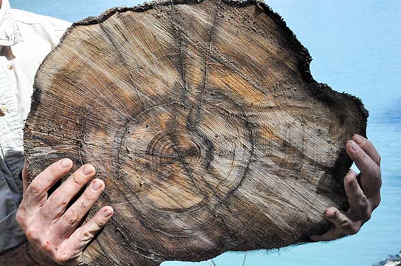
In 2011, Dr. Wiles and his advisees Lauren Vargo and Jennifer Horton cored dozens of trees from Tree Mountain in Alaska’s Glacier Bay National Park and Preserve. Muir Glacier is located northwest of this mountain, named after the esteemed naturalist and preservationist John Muir.

John Muir in Sierra Nevada, courtesy of PBS.

John Muir in Sierra Nevada, photo courtesy of PBS.

Muir first traveled to the area in 1879 with a particular interest in Alaska’s glaciers. He returned many times, continually fine-tuning his preservationist vision while drawing from theistic and transcendentalist ideas to transform the public’s perception of wilderness. Muir’s published works recalling these expeditions sparked national interest in Alaska’s wilderness and its preservation, laying the foundation for environmental debates yet to come.

Map of Glacier Bay, edited by John Muir. Published in the book Alaska Days With John Muir.

Map of Glacier Bay, edited by John Muir. Published in the book Alaska Days With John Muir.

Though the Tlingit lived in the Glacier Bay region for centuries, and others explored the area before him, Muir was the first distinguished scientist to map it and record his observations.

map

Above is a present-day map of Glacier Bay, courtesy of Google Earth. Tree Mountain is marked in red on the southern border of Adams Inlet, which feeds into Muir Inlet. Muir Glacier lies at its base. Note the altered position and size of the glacier in comparison to Muir’s map.comparison

Photographs from the National Snow and Ice Data Center famously portray Muir Glacier’s retreat. Between 1941 (left) and 2004 (right), the tidewater glacier retreated more than seven miles, though it has been rapidly retreating since the end of the Little Ice Age in the mid 1800s.

Photograph of Muir Glacier from Alaska Days With John Muir.

Photograph of Muir Glacier from Alaska Days With John Muir.

Muir observed the rapid retreat of glaciers, expressing concern for Alaska’s changing climate and frustration with potential anthropogenic causes, specifically deforestation. In October of his 1879 expedition, he wrote in his journal, “That the climate is warmer is shown by the melting shrinking condition of the glaciers… where formerly much snow fell to thaw off gradually, incessant flood-rains fall, saturating the soil, causing it to decay and become slippery and wash off… It was not in this condition while the forests existed.”

Muir’s 1895 journal sketch of Muir Glacier from Tree Mountain.

Muir’s 1895 journal sketch of Muir Glacier from Tree Mountain.

To learn more about the climate in the Glacier Bay area when Muir recorded his observations, I measured the tree-ring widths of the Tree Mountain cores. Twenty of the Tree Mountain samples dated back to the mid 1800s or later, allowing me to compare tree-ring records with John Muir’s notes from his 19th century expeditions.

core

The growth patterns of tree-rings vary based on the species, age of the tree, and other environmental factors. However, tight growth patterns, representing little growth, are typically an indication of stress. Increased growth usually reflects temperature, precipitation, the availability of nutrients.

ring width

This figure above shows the standardized raw ring widths of the twenty cores from Tree Mountain. The growth trend has been removed. The blue line beneath the raw data represents the number of cores measured each year.

charttA 2014 study headed by Dr. Wiles provides a chronology and climate reconstruction for the entire Gulf of Alaska over the past 1200 years.

According to my Tree Mountain findings, John Muir’s 19th expeditions in Alaska occurred during a period of gradual warming, aligning with the chronology provided in Dr. Wiles’ study. However, the small Tree Mountain sample size poses difficulties in making significant comparisons, as well as the complexities of the numerous factors that influence both ring width and temperature, which are not accounted for in this post. Further comparisons of the paleoclimate record and the writings of John Muir in Glacier Bay continue..

Posted in Uncategorized | 1 Comment

Russian Birch Climate Reconstruction- Part 2

Guest blogger- Clara Deck

This summer, I am working with Dan Misinay to continue a dendrochronology project focused on Kamchatka, Russia. We have been working with birch tree cores (Bertula ermanii) collected from the region by Dr. Wiles and I.S. student Sarah Frederick in the summer of 2014.

DSC_0015

Our goal is to use the cores to gather information about the climate. By counting, measuring and comparing different cores, Dan and I developed separate tree ring width chronologies from different areas in Kamchatka.

Kamchatka Peninsula GE

My samples are labeled NR in the northern part of the Kamchatka peninsula, while Dan’s are labeled UG. SANO represents birch cores in a study by Sano et al, 2009. The UG and SANO data correlates very well together, but the NR data is in a much different latitudinal location, and does not correlate. With the Sea of Okhotsk to the east, the Pacific Ocean to the West, and numerous mountain ranges and volcanoes, there are many climate factors that may influence the growth of these trees along the peninsula. The following work deals solely with my samples (NR).fulltabs

Shown here in green is the standardized data for the entire chronology (1823-2014). Trends in this graph may indicate climate signal and will be further analyzed this summer. The blue line represents the number of samples for each given year.

mintemp

I compared my tree ring data with meteorological data from a nearby weather station in Kljuci, Russia (also spelled Klyuchi). This graph shows the correlation of the tree rings with the minimum temperatures for each month. Months from the previous year are labeled t-1, while the present is year t. High positive correlations are shown during March through August of the present year, indicating that minimum temperatures in these months primarily influence the tree ring widths. Though this graph only shows correlations with minimum temperatures, I found the same trend with maximum and mean temperatures.

shiveluch

The map above shows a zoomed in region of northeast Kamchatka with spruce (Picea) and larch (Larix gmelinii) samples from a study called Constraining recent Shiveluch volcano eruptions (Kamchatka, Russia) by means of dendrochronology (Solomina, et al 2008). Shiveluch volcano is adjacent to the site where the birch tree samples were collected, and all of the samples shown could be affected by its volcanic activity. It is one of the most active volcanoes in Kamchatka, and a significant eruption was recorded in 1964 (Solomina, et al 2008). The tree ring record should show evidence of this eruption in the year 1965. The study indicated that although a slight decrease was shown in their cores, it was of negligible scale and does not provide clear evidence of the eruption. I am interested to see if my samples show evidence of the eruption, because of its different position relative to the volcano.

1965

Shown here is isolated data from 1950-1980 from the above shown chronology, and shows a drop off in ring width growth in 1965. This could be evidence of a volcanic eruption, but as you can see even in this small data set, variability like this is not uncommon. More work needs to be done to determine the significance of this decrease.


References:

Sano, M., Furuta, F., and Sweda, T., 2010, Summer temperature variations in southern Kamchatka as reconstructed from a 247-year tree-ring chronology of Betula ermanii: Journal of Forest Research, v. 15, p. 234–240, doi: 10.1007/s10310-010-0183-z.

Solomina, O., Pavlova, I., Curtis, A., Jacoby, G., Ponomareva, V., and Pevzner, M., 2008, Constraining recent Shiveluch volcano eruptions (Kamchatka, Russia) by means of dendrochronology: Natural Hazards Earth Systems Sciences, doi: 10.5194/nhess-8-1083-2008

Posted in Uncategorized | Tagged , , | 4 Comments

Goodygoody Girdwood Chronology Construction

 Guest bloggers: Kaitlin Starr and Maddie Happ
BLOG4

Forest surrounding Girdwood, Alaska. Living mountain hemlock trees were cored from this site (Wiles, 2014).

    During the summer of 2014, the Columbia Bay team (Dr.Wiles, Nick Wiesenberg, Kaitlin Starr and Jesse Wiles) cored numerous trees near the town of Girdwood, Alaska. The collection is primarily made up of cores taken from living Mountain Hemlock trees from the surrounding forest. In addition to the living forests a few cores were taken from subfossil wood at Turnagain Arm.
DSC_0064

Kaitlin Starr coring a living Western Hemlock found in the forests surrounding the town of Girdwood (Starr, 2014).

    The Girdwood living tree collection was brought back to the Wooster Tree Ring Lab where the cores were mounted, sanded, counted and measured. Students, Maddie Happ and Kaitlin Starr constructed a chronology out of 38 cores sampled. The chronology spans 342 years, beginning at 1672 and extending to 2014. When compared to the established Turnagain Pass chronology by Jacoby, G.C., D’Arrigo, R.D., Buckley, B., our new Girdwood chronology correlated well. In addition, our chronology extends the known database for the region by contributing an additional 85 years of data.
Blog2

Girdwood core sample illustrating both tight and normal growth patterns. Growth patterns may vary due to shifting climates. Tight growth often occurs during periods of distress, such as drought or storms.

    The graph below illustrates the standardized tree ring measurements by removing biological growth trends from   the series. Removing growth trends allows us to view the desired climate signal.
Blog4

Standardized Girdwood chronology note the upward trend in the series . The red line indicates the sample size.

The chronology was compared with meteorological data from the nearest station, Anchorage (International Airport) and correlations are plotted below. We found an unexpected high negative correlation between our chronology and the minimum temperature data, specifically throughout the summer months (June, July and August). The possible cause of this correlation is unknown at the moment.

Screen Shot 2015-06-12 at 11.21.19 AM

This graph illustrates the overall correlation between tree ring width and mean temperature and precipitation in Girdwood, Alaska for the dendroclimatic year.

Screen Shot 2015-06-12 at 11.21.43 AM

The above graph displays the overall minimum temperature compared to the tree ring widths for Girdwood, Alaska. A clear significant negative correlation exists for the months of May, June, July, and August.


Posted in Uncategorized | 1 Comment

Taking a break to see York

1 Mae Meredith SW York MinsterSCARBOROUGH, ENGLAND (June 12, 2015) — Team Yorkshire went on a holiday today with a visit to York, only a short train ride inland from Scarborough. We needed a break, and in any case the tides were not in our favor at Meredith’s Independent Study field site. It was another extraordinarily warm, clear and dry day. (Unlike the cold, foggy and damp Scarborough we returned to in the evening.)

Above Meredith and Mae stand in front of the southwestern portion of the iconic York Minster.

2 Mae Meredith York StreetHere we are walking down a York street. The city felt very large and busy after our days in Scarborough.

3 River Ouse in York from Skeldergate Bridge 585The River Ouse in York from Skeldergate Bridge. This river divides the city and has been an important transportation and trade route for centuries.

4 Constantine 061215This statue of the Roman Emperor Constantine the Great is a monument to his accession to the office in 306 CE while in York, then known as Eboracum.

We spent time at the Viking archaeological center (Jorvik) and the York Castle Museum before taking the train back “home” to Scarborough. It was a great cultural excursion as we prepare for our last days of fieldwork.

Posted in Uncategorized | Tagged , , , | Leave a comment

Museum work and a castle visit in Scarborough

1 Scarborough museum workSCARBOROUGH, ENGLAND (June 11, 2015) — It is always useful when doing paleontological fieldwork to visit the local museum to see what specimens they’ve curated over the years. Today Team Yorkshire explored the collections at the Scarborough Museums Trust Woodend storage facility, courtesy of Jennifer Dunne, Collections Manager. Above are Mae Kemsley (’16) and Meredith Mann (’16) examining boxes of specimens from the Speeton Clay and Coralline Oolite, the two units they’re working with.

2 Peltoceras williamsoniThis specimen of the ammonite Peltoceras williamsoni is an example of the kind of material we find in museum collections. It comes from the Passage Beds of the Coralline Oolite — Meredith’s unit. We are not likely to come across such a well-preserved fossil in our short interval of fieldwork. This is not the first Peltoceras in this blog.

3 Peltoceras noteThis note that accompanied the above specimen is from J.K. Wright, an expert with these fossils.

4 Scarborough castle keepAfter our museum work, we took an opportunity to visit Scarborough Castle. (We couldn’t do more fieldwork this afternoon because of the high tides.) This is a spectacular place with over 3000 years of history. It was the site of settlements in about 800 BCE and 500 BCE, and then a Roman signalling station around 370 CE. The castle itself dates back to the 12th Century. In 1645 it was the subject of a long Civil War siege, with Parliamentarians on the outside shelling Royalists on the inside. (The cannonades broke the above castle keep in half.) In December 1914, German battleships fired over 500 shells into it.

5 Team Yorkshire castle 061115Mae and Meredith with the castle keep in the background. Note the fantastic weather!

6 St Marys chapel castleThe remains of St. Mary’s Chapel within the castle walls were built on the site of the Roman signals station. Resident of the castle took shelter here during the 1914 German bombardment.

7 Scarborough from castleA view of Scarborough from the castle walls. We could see all of our field areas along the coast from this vantage point.

Posted in Uncategorized | Tagged , , , , , , | Leave a comment