I’m so tired I don’t even want to title this.

Guest Blogger: Becky Alcorn

Yesterday we spent the day in Undirhlithar mapping the quarry wall that will be the focus of my IS. We climbed the majority of the wall with the exception of a few unstable places and collected a hearty 25 samples (some from places that I’m still not quite sure how we managed to reach). We finished up in Undirhlithar today and traveled farther south to another quarry, Vatnskarth. Here we could see were the lava met the glacial deposit, which was awesome! We collected samples for Meagen and then came back home so I could get to the nitty gritty of labeling my pictures. I spent many hours today sorting through my pictures and labeling where I collected each sample, which is much more tedious and time consuming than it sounds. Tomorrow we’re heading east for two days to camp and see Eyjafjallajokull! We’ll be sure to post when we return, so if you don’t hear from us in a few days we were probably swallowed up by the volcano.

Bustin out the brunton

Collecting a sample from the top of the quarry. I didn't enjoy being up that high but it was worth it.

One of the many pictures I labeled today even though it was beautiful outside.

Posted in Uncategorized | Tagged , | 3 Comments

The Bonneville Flood and where it began

DOWNEY, IDAHO–Lake Bonneville has been one of the geological themes of my short visit to northern Utah this summer. The remnant wave-cut platforms of its shorelines dominate the geomorphology of the Logan area, and the lake sediments are the basis for the rich soils of the Cache Valley. Today my parents and I visited Red Rock Pass in southern Idaho where this massive lake breached a weak area of limestones and shales 14,500 years ago and then catastrophically flooded the land to the north. The Bonneville Flood was not as large as the Missoula Floods of geological legend, but it left a very similar record of scoured land, scattered boulders, huge waterfalls, and thick gravel bars.

Red Rock Pass near Downey, Idaho. The rocky hill in the center was part of the dam of sedimentary rocks which gave way 14,500 years ago and released the catastrophic Bonneville Flood.

View north from the dam area looking down one of the flood channels. On the left is a rocky outcrop of the original dam. On the right along the side of the channel is a gravel bar running parallel to the current direction.

Posted in Uncategorized | Tagged , | Leave a comment

Tragedy at Bear River: two very different historical narratives

PRESTON, IDAHO–I knew on our drive this morning that Preston, Idaho, is famous as the setting for the Napoleon Dynamite movie. (You can even download “Napoleon Dynamite’s sweet map” of the town.) I did not know that just north of Preston on US Highway 91 is a place of great sadness — and some lessons about history.

Confluence of the Bear River and Battle Creek north of Preston, Idaho.

Bear River and Battle Creek join here in a fertile valley with green meadows and quiet farms. In January 1863, US Cavalry and infantry attacked a camp of Shoshone in what became known as the Battle of Bear River — and then much later  as the Bear River Massacre. You can follow the links to read the full story. I want to call attention to the separate narratives of the conflict found in two sets of memorials on the site:

Older account of the Battle of Bear River on a memorial erected by the Daughters of the Utah Pioneers and other groups.

A modern sign that is part of a memorial established by the Western Shoshone on a hilltop overlooking the site.

History as with science requires evidence to support hypotheses, and all such ideas are provisional because we never have all the information we need. Some hypotheses are stronger than others, though, as we weigh the evidence and the arguments. The tragedy at Bear River is a case where the more complete story only emerged into the public generations later. It is difficult to believe that one of the largest massacres of Native Americans in history is still so poorly known 147 years later.

Shoshone prayer tree at Bear River.

Posted in Uncategorized | Tagged , , | Leave a comment

Sure this is a geology blog, but these wildflowers …

… are fantastic!

Blue flax, Indian Paintbrush and other wildflowers near Tony Grove Lake, Cache County, Utah.

Geologists are natural historians, so of course anything natural (or historical!) fascinates us. Stephanie Jarvis showed us some flowers (and mushrooms) in Alaska this summer. Last year we looked at acacia trees in Israel. We’ve even delighted in moss, flowers and wild strawberries in Estonia. The wildflowers this week in Logan Canyon, northern Utah, are extraordinary. In keeping with tradition, I want to share a few.

Colorado Columbine (left); Scarlet Gilia (right).

Blue Flax (left); Sticky Geraniums (right).

Floret of a Giant Gentian (left); florets of the Elephant's Head Figwort (right).

Posted in Uncategorized | Tagged , | 2 Comments

Geysers, Mountains, and Dinosaurs…OH MY! (Subtitle: This Summer is Stromato-Tight)

Guest Blogger: Elizabeth Deering

This summer I have been given many amazing opportunities starting with my employment at the Wyoming Dinosaur Center in Thermopolis, Wyoming. Since late May I have been working with 7 other summer staff members giving tours, working in the prep-lab, and excavating Camarasaurus and Allosaurus bones. Excavating bones is a lot different than what you see in the movies and its definitely not as easy, but it is still a lot of fun. We use dustpans, brooms, oyster knifes, and occasionally hammers and chisels to excavate the bones, but before we can remove them we have to take many measurements and GPS coordinates so we can map the bones for further study. This summer we have found many vertebrae, teeth, and even some cranial material! One of the coolest finds was discovered on accident when a staff member broke an Allosaurus humerus in half with a chisel. The inside of the humerus was hollow and had been replaced with an unidentified mineral, making it look like a geode. It was a very unique find for the center.

Two summer staff members and myself working on excavating a Camarasaurus at the BS (Beside Sauropod) quarry at the Wyoming Dinosaur Center.

Two summer staff members and myself working on excavating a Camarasaurus at the BS (Beside Sauropod) quarry at the Wyoming Dinosaur Center.

Thermopolis is only a few hours from both Yellowstone National Park and Grand Teton National Park, so my roommates and I have taken advantage of our location and made a few weekend trips to both parks. They are both amazing! Yellowstone is unique because of the drastic changes in landscape that you encounter while driving through the park. In places it can be very wooded and have an alpine feeling, while in other places it can be very desolate and have lots of geothermal activity. Personally, I liked the more desolate landscape of Yellowstone. It was amazing to see things like geysers, paint-pots, and mineral springs. The Tetons were also incredible. They are younger mountains, so they have less erosion and are more jagged than other mountains. There is absolutely breathtaking scenery in the Tetons and many fun activities as well. If you ever find yourself in Wyoming I recommend seeing both parks.

Fountain Paint-Pot, Yellowstone National Park, Wyoming.

Fountain Paint-Pot, Yellowstone National Park, Wyoming.

Grand Teton National Park, Wyoming.

Grand Teton National Park, Wyoming.

Right now I am in Ephraim, Utah, with Dr. Judge and Jesse Davenport working on my Senior I.S. on stromatolites in the Green River Formation. This past week we have worked hard in the hot sun collecting samples and making strat columns. We have gathered a lot of great samples and lots of important information to include in my paper, but we have had a lot of fun too! I am here in Utah until Tuesday and then I fly back to Thermopolis to finish up the summer.

Posted in Uncategorized | Tagged , , , , , | 4 Comments

A Great Unconformity

I almost forgot our quick side trip at the end of the day. With the Green River Formation behind us (literally, in this photo), we turned to view a fantastic example of an angular unconformity here in central Utah. Although there are several significant unconformities in the area, this unconformity is probably my favorite, because it shows paleotopography as you follow it regionally from west to east.

The photo above shows the unconformity that places the Paleogene Colton Formation on top of the vertical Jurassic Twist Gulch Formation.

The photo above shows the unconformity that places the Paleogene Colton Formation on top of the vertical Jurassic Twist Gulch Formation.

Posted in Uncategorized | Tagged , | Leave a comment

If We Only Had a Rock Saw in the Field…

Today was our final day on one of the Green River cuestas. We decided to top it off by working a quite extensive section of the formation with a great climb to reach the stromatolites. However, the climb was completely worth it, because the view of the Valley was amazing.

The photo shows one of the smaller stromatolites that we encountered today.

The photo shows one of the smaller stromatolites that we encountered today.

Some of the stromatolitic or thrombolitic structures that are within the Green River are quite large. In the photo above, there are thin laminations at the very top of this structure, which are possibly a result of an algal mat. Other structures in this more massive bed are approximately 2 feet thick and might be stromatolites or thrombolites or...???...It is just too bad that we didn't have a rock saw in the field. If I only had a saw to see these features in cross-section. Don't worry, though, we have about 500 pounds of stromatolites coming back to Scovel Hall!!

Some of the stromatolitic or thrombolitic structures that are within the Green River are quite large. In the photo above, there are thin laminations at the very top of this structure, which are possibly a result of an algal mat. Other structures in this more massive bed are approximately 2 feet thick and might be stromatolites or thrombolites or...???...It is just too bad that we didn't have a rock saw in the field. If I only had a saw to see these features in cross-section. Don't worry, though, we have about 500 pounds of stromatolites coming back to Scovel Hall!!

The fabric on some of the beds was amazing.  We have really come to appreciate the various textures that can be seen within stromatolitic beds.

The fabric on some of the beds was amazing. We have really come to appreciate the various textures that can be seen within stromatolitic beds.

After we completed our cuesta stratigraphy, we drove to Soldier Canyon to admire the exposures of the Green River in all of its glory.  Elizabeth, who has really taken to the west, decided to do a little house hunting.  There were several of these dwellings within the formation, but this one seemed to be the most spacious.  You should see the interior design!!  Elizabeth just loved what they've done with the decor.

After we completed our cuesta stratigraphy, we drove to Soldier Canyon to admire the exposures of the Green River in all of its glory. Elizabeth, who has really taken to the west, decided to do a little house hunting. There were several of these dwellings within the formation, but this one seemed to be the most spacious. You should see the interior design!! Elizabeth just loved what they've done with the decor.

Posted in Uncategorized | Tagged , | Leave a comment

To the Victor Goes the Spoils…

The Utah gang was back at it in the Green River Formation, which is exposed in one of the cuestas in the Sanpete Valley. It was a wonderful 100 degrees by midafternoon, and I think that even the fossil ostracodes were beginning to sweat. Our goal today was to investigate a couple of quarries, and first thing in the morning, Jesse found an very intriguing stromatolite layer about 5 feet above the top of our first quarry. There were smaller stromatolites, which provided a base for the much larger stromatolites.

This photo highlights the size differences between the stromatolites that were found within the same interval in our first quarry.  A penny in the photo is used for scale.

This photo highlights the size differences between the stromatolites that were found within the same interval in our first quarry. A penny in the photo is used for scale.

Elizabeth noticed that several centimeters of the surface of some stromatolites had a very interesting tube-like fabric.  We cannot wait to get this back to the Wooster lab for some additional work to identify these structures (and for some expert opinions from Dr. Wilson!!).

Elizabeth noticed that several centimeters of the surface of some stromatolites had a very interesting tube-like fabric. We cannot wait to get this back to the Wooster lab for some additional work to identify these structures (and for some expert opinions from Dr. Wilson!!).

We were able to look at three different quarries within the cuesta. While Elizabeth and I were working in quarry #2, Jesse went to one of the other cuestas in the Sanpete Valley for some recon work on the quality of the stromatolites there. The Black Hill quarry that Jesse visited is enormous, but he reported back that the quantity of stromatolites was disappointing. So, we hiked to quarry #3, where Elizabeth attracted yet another scorpion. (As I have learned, Elizabeth seems to have a real gift for attracting scorpions, wasps, huge bees, and fire ants.)

Quarry #3 was great!! Although we were supposed to be looking for mudcracks, our attention strayed. First, we were fascinated that the small scorpion seemed to be very angry at Elizabeth for flipping over a stromatolite (its home), and seemed to chase her. But, then things got very interesting…The scorpion rested near a small bush, and before you knew it, a lizard was stalking the scorpion. In a flash of an eye, we watched the lizard grab the scorpion and run away with the prize, all the while capturing everything with the camera. National Geographic, here I come!!

Notice the small lizard in the top center of the photo.  This was the instant that the lizard grabbed the scorpion from between the small bush.  Things in the photo are a little fuzzy, because the lizard moved so quickly.

Notice the small lizard in the top center of the photo. This was the instant that the lizard grabbed the scorpion from between the small bush. Things in the photo are a little fuzzy, because the lizard moved so quickly.

Our fierce lizard scrambled to a nearby rock to celebrate its find.  Sadly, the scorpion had no chance.

Our fierce lizard scrambled to a nearby rock to celebrate its find. Sadly, the scorpion had no chance.

Posted in Uncategorized | Tagged , , , | 4 Comments

The utility of trace fossils

LOGAN, UTAH–Today we hiked north of Tony Grove Lake in Logan Canyon to explore an Ordovician sequence of rocks. The most interesting unit (to my surprise) was the Swan Peak Quartzite, an orange-brown unit at the base of a white dolomite and gray limestone. It weathers in sharp edges and large blocks tumbled down the slopes. Quartzite began as a quartzose sandstone which was metamorphosed into a rock where the silica cement is as hard as the quartz grains. Most fossils are destroyed in this metamorphosis, along with almost all sedimentary features, so I didn’t expect to see much in the Swan Peak.

Outcrop of the Swan Peak Quartzite (Ordovician) north of Tony Grove Lake, Utah. This photograph was taken facing north at N41° 54.198′, W 111° 38.72′.

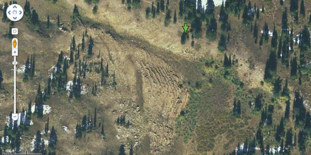
Google Earth image of the Swan Peak Quartzite exposure. The green arrow is the location from where the outcrop photograph above was taken. The stepped nature of the rocks is easily visible in the middle of the image.

The Swan Peak Quartzite is exposed here as a series of large steps looking something like a side of an eroded Egyptian pyramid. Why does it erode into this kind of stairway instead of one large block? A close examination of the rock surfaces revealed trace fossils were preserved — the kind of fossils which could be clues to the character of this formation.

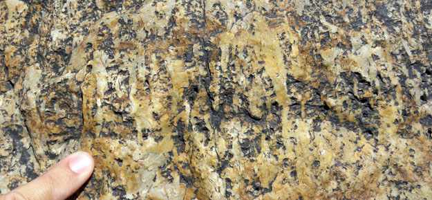
Horizontal burrow systems preserved in remnant bedding planes of the Swan Peak Quartzite. These traces give the rock its local name of “Fucoidal Quartzite”. Fucoidal is an old word for trace fossils.

Vertical burrow systems (Skolithos) exposed on vertical faces of the Swan Peak Quartzite.

It appears that the step surfaces have horizontal burrow systems, and the “risers” have vertical burrows (Skolithos). There is an alternation of beds with horizontal burrows and beds with vertical burrows through the Swan Peak Quartzite. The horizontally-burrowed units are less resistant than the vertically-burrowed units, so this alternation produces the stepped erosion pattern.

My hypothesis is that the horizontal burrows represent slightly deeper water than the vertical burrows, based on the distribution to such burrow systems in other formations and in today’s oceans. The alternation between the two trace fossil types may thus show fluctuating sea levels as the Swan Peak sediments were deposited way back in the Ordovician.

So, this unpromising rock may indeed be providing clues to its ancient depositional environment through the trace fossils it contains.

[Author’s note (July 27, 2020): Dave Powelson kindly pointed out to me that the Swan Peak Quartzite is not actually a metamorphic quartzite but a silica-cemented orthoquartzite sedimentary rock. I should have called it by its more neutral name, the Swan Peak Formation. This solves the mystery of why the trace fossils are so well preserved. Thanks, Dave!]

Posted in Uncategorized | Tagged , , | Leave a comment

Ancient shorelines

LOGAN, UTAH–The Wooster geology team currently in central Utah pointed out in the distance Pahvant Butte which has a set of relict shorelines from the famous — and immense — Lake Bonneville. In the spirit of sharing common field experiences between Wooster geologists this summer, we have Bonneville shorelines up here in northern Utah as well. This pluvial lake was extraordinarily large, filling a good portion of the Great Basin between 32,000 and 14,500 years ago. Its shores were energetic with strong waves pounding away at the confining mountain slopes and forming wave-cut platforms which extended inland hundreds of meters in some places. The area around Logan, Utah, has especially well developed Bonneville shoreline platforms.

Looking west at the Utah State University campus in Logan sitting on a Lake Bonneville wave-cut platform. In the background are the Wellsville Mountains, with the Cache Valley in between.

Wave-cut platforms (or terraces) on the flank of the Bear River Range in Logan, Utah. The oldest levels are the highest because they have eroded away previous shorelines. The lower platforms represent decreasing lake levels over time.

The Great Salt Lake of Utah is a remnant of the once vast Lake Bonneville. Tomorrow I hope to see where the lake catastrophically drained about 14,500 years ago (the Bonneville Flood).

Posted in Uncategorized | Tagged , | 1 Comment