This semester, I’ve had the pleasure of teaching a special topics lab course in geochemistry. Given our new lab facilities, I decided to approach the class as an analytical geochemistry course. We explored sampling strategies, data quality, and the theory and techniques behind X-ray methods (XRF), electron-beam methods (SEM-EDS), and mass spectroscopy methods (ICP-MS). Unlike a typical survey course, our course was entirely research-based. We actually became analytical geochemists by conducting an authentic research project on a suite of Icelandic basalts. Our goal was to investigate the development of a structural basin in northern Iceland by interpreting the petrogenesis of lavas that were erupted during different phases of basin construction. This week, we’ve accomplished our goal and have written an abstract to submit to the Fall 2012 meeting of GSA.
Here is the text of the abstract:
A GEOCHEMICAL ANALYSIS OF THE VATNSDALFJALL STRUCTURAL BASIN, SKAGI PENINSULA, NORTHWEST ICELAND
Matthew Peppers, Sarah Appleton, Lindsey Bowman, Andrew Collins, Whitney Sims, Melissa Torma, Meagen Pollock
Vatnsdalfjall, in northwest Iceland, exposes the upper ~700 m of crust formed ~7 Ma ago at the extinct Hunafloi-Skagi rift zone. In general, the lava flows dip gently westward toward the abandoned rift axis, but are interrupted by a local area of steeply dipping lava flows known as the Vatnsdalur Structural Basin (VSB). The VSB is composed of three sequences of lava flows emplaced before, during, and after subsidence. Using the geochemistry (XRF, ICP-MS) of samples gathered in the field in 2006 and 2007 and previous data from Ackerly (2004) and McClanahan (2004), we were able to establish a basic eruptive history for the sequences. Major element analysis shows diverse rock types, including basalt, basaltic andesite, dacite, and rhyolite. Sequence 1 shows the greatest diversity and was primarily affected by mineral accumulation, while Sequences 2, 3, and the dikes follow the trend of a shallow level fractional crystallization model based on a modified parent magma from Sequence 1. Trace element ratios suggest the presence of 1 (or 2) parent magmas, although the intermediate to silicic lavas appear to be generated by a separate process. Sequence 1 contains various lava flows, each with a uniform thickness, emplaced on relatively flat terrain. Sequence 2 was emplaced on top of Sequence 1 as subsidence of the basin was occurring, creating lava flows that thicken toward the basin interior. Intermediate to silicic rocks are absent during this interval and dikes cut Sequence 1 to feed lavas in Sequence 2. After a period of erosion, Sequence 3 was erupted above Sequence 2. Dikes that feed Sequence 3 cut through Sequence 2. The development of the VSB may have been associated with a waning period in the magmatic system, where magmas cooled and evolved (following an evolutionary trend controlled by fractional crystallization) and there was little partial melting of the crust (given the lack of intermediate to silicic lavas).
And some key figures:
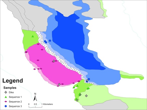
Geologic map that shows the location of our samples on Sequence 1 (green), Sequence 2 (pink), and Sequence 3 (blue).
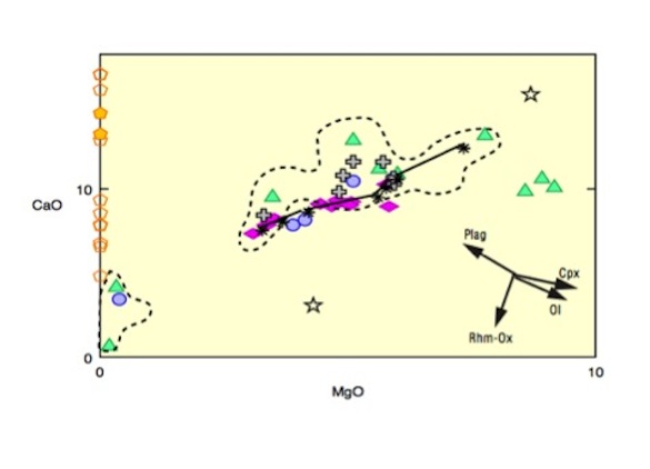
CaO vs. MgO (wt%). Symbols for dikes and Sequences 1, 2, and 3 are as shown on the geologic map. Previous data outlined by the dashed line. Fractional crystallization model shown by the black like. Arrows indicate effects of mineral accumulation. Plagioclase (pentagons) and clinopyroxene (stars) are also shown.
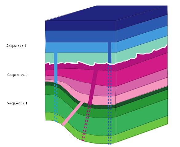
Schematic model (not to scale) for the development of the basin.
I applaud all of the students for their excellent work. They really took ownership of this project and deserve all of the credit. Look for us at GSA in the fall!