Editor’s note: The following post is from guest blogger Annette Hilton (’17) about her extraordinary research experiences this summer. Annette gets around: You may remember her post last summer from the American Museum of Natural History.
This summer I have the privilege of working an REU (Research Experience for Undergraduates) internship with NASA Student Airborne Research Program (NASA SARP). The program has employed 32 undergraduates from all over the United States to explore airborne Earth science with four amazing mentors, all associated with NASA and universities from around the USA.
 The program takes place in southern California—the first week spent in Palmdale, CA, where the NASA Armstrong Flight Research Center is located. The second week SARP is split into four teams of eight students for specific research areas—Coastal Ocean and Remote Sensing, Forest and Remote Sensing, Atmospheric Chemistry, and Whole Air Sampling—and team field trips. The remaining six weeks will be spent in Irvine, on the UC Irvine campus, for data analysis.
 Figure 1. Armstrong Flight Research Center, where all of NASA’s Earth Science airborne campaigns take place. The hangar pictured above houses several planes, including the DC-8.
SARP flies two missions on board the DC-8, NASA’s airborne laboratory. On Saturday June 18th I flew on board the DC-8 for a six hour flight over the Central Valley and Santa Barbara Channel.
 Figure 2. Map of flight plan for the DC-8 on June 18th. The red circle indicates an area we had to unexpectedly plan around, as President Obama was camping with his family in Yosemite. This map does not include our added flight path above the Santa Barbara channel.
 Figure 3. The DC-8 outside the hangar at NASA Armstrong Flight Research Center.
 Figure 4. As you can see, the plane has been heavily modified for all the scientific equipment it houses! Most instruments on board sample and analyze data real time.
 Figure 5. Inside the DC-8. The aircraft had just returned from a six week mission in South Korea, called KORUS-AQ, an international cooperative air quality field study. Because of this, the DC-8 was decked out with all the KORUS-AQ instruments, which SARP was able to have access to! When I was on board there were at least 40 different instruments, as well as most of the KORUS-AQ team.
 Figure 6. More scientific goodies!
During the six hour flight we primarily flew in the Planetary Boundary Layer (PBL) (~1000-4000 ft altitude) in order to be close to emissions over the Central Valley. Our flight plan included flyovers of large dairy farms, oil fields, agricultural fields, and the Santa Barbara channel. We flew a few missed approaches where we got to about 40 feet above ground before flying back up to the PBL in areas of particular interest as well as a vertical spiral to create a profile of the atmosphere. I was even able to ride for 20 minutes in the cockpit and speak briefly with the pilots! Luckily, I was not one of the students on board who became ill during the flight. Flying in the PBL is very hot and a bumpy ride!
 Figure 7. Outside my window in the PBL over the Central Valley.
 Figure 8. Outside my window over the Santa Barbara channel, in smoke from the Sherpa Wildfire.
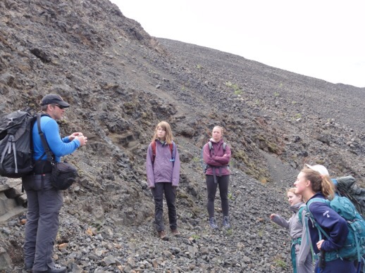
The first SARP flight on June 17th flew over the Los Angeles Basin. In addition, SARP has access to another one of NASA’s planes, the ER-2 (a pilot only plane), which will fly two missions for SARP above the same areas the DC-8 flew in order to obtain high altitude data (the ER-2 can fly up to 70,000 ft). SARP will also have access to the data obtained during the KORUS-AQ mission, as well as ground-based data during the second week field trips. My group, Coastal Ocean and Remote Sensing, will be traveling to Santa Barbara for a day cruise out on the channel to collect water samples. These data will eventually be used to calibrate and validate both airborne and satellite data obtained during SARP over the coastal area.
 Figure 9. The Coastal Ocean and Remote Sensing group in front of the DC-8.
I am very excited to be in California this summer working with a wonderful group of peers and mentors at SARP. SARP has access to a plethora of data which I will utilize to design my own research project for the summer, which I also hope to continue during my senior independent study at Wooster.
A shout out to all the wonderful professors in the Wooster Geology Department who I owe many thanks to for their help in being able to participate in such an amazing experience! Thank you for all you do.