Jackson Peak section: Another gnatty adventure

This morning the Wooster Geologists visited the westernmost exposure of the lower Carmel Formation at Nielson’s (1990) Jackson Peak section. Nick and Vicky are shown above on the road towards the conical Jackson Peak in the background. The site was as buggy as any other on this trip, with not a breath of wind to relieve us.

Nick took this image of our team hiking up a wadi in search of a good place to make a stratigraphic column. Jackson Peak looms in the background.

We established the base of the section in a wadi at N 37.327356°, W 113.858144°. Because of the rough terrain, the gnats, and the mostly-covered nature of the stratigraphy here, we decided to use Nielson’s (1990) original measurements and then sample along his column. Note that burned trees give very little shade.

Another image by Nick of Wooster Geologists at work. In the background is Square Top Mountain, which is most notable as the site of a B-52G crash in 1983.

This is the highest in-place outcropping of the typical lower Carmel Formation stromatolitic micrite beds. You can see the fine microbial layering on the weathered surfaces of the rock. Sampled as JP-1.

Like an old friend, the distinctive sandstone we saw in the Manganese Wash section showed up here at Jackson Peak. It has the same weathering appearance and, at the handlens level, the same lithological composition. Sampled as JP-2.

Unlike at the Manganese Wash section, the sandstone at Jackson Peak has an ooid shoal biosparite/grainstone directly above it, our sample JP-3.

This ooid shoal deposit as the same low-angle cross-bedding and current ripple marks as we’ve seen in all our Carmel Formation sections.

At the top of the ridge we were studying, Lucie and Vicky came across our second rattlesnake of the trip. It buzzed immediately, so Lucie and Vicky moved away quickly. Nick got this great image.

On our way back from the Jackson Peak section we met two Bureau of Land Management officers on horseback. Now there’s a cool job. (Photo by Nick.)

As is our tradition on these southwestern Utah expeditions, after we finished our work at Jackson Peak, we visited the 1857 Mountain Meadows Massacre site a few miles to the north.

This is the cairn marking the mass grave of 34 of the victims buried on the massacre site. It is a sad and enraging story we encourage you to read at the link above.

Posted in Uncategorized | Tagged , , , | Leave a comment

Up the steep slopes for a trace fossil reward in Dammeron Valley

Today Team Utah 2022 climbed the outcrops in Dammeron Valley, north of St. George, to collect trace fossils from the Co-op Creek Limestone Member of the Carmel Formation (Middle Jurassic). It was a bit of a slog up the rubbly talus cones that provided passage over the cliffs, but the trace fossils up there were worth it. Beautiful day, but our friends the gnats lurked in the shadows. Thanks to Nick for the image.

The very base of the section is the gypsum-bearing red claystone and siltstone Temple Cap Formation, shown here with Lucie for scale.

About midway up the slope, just above the highest stromatolitic unit, abundant trace fossils appear. Vicky is ready to collect!

The trace-bearing outcrop is not very photogenic, but those brown slabs on the surface have numerous ichnofossils. Location: N 37.276667°, W 113.640350°.

The red marker shows our study site in Dammeron Valley. Note it is just above the boundary between the whitish lower part and brown upper part of the member.

I was particularly interested in these funnel-shaped traces (the circular pits), which were abundant, along with the familiar Gyrochorte. We haven’t seen these elsewhere in the Carmel Formation in SW Utah.

This slab shows a thick mass of Planolites trace fossils. Each stripe on the Jacob’s Staff is 10 cm.

And that was it for the day. Later we’ll report here on what we found after our lab analyses back in Wooster.

Posted in Uncategorized | Tagged , , , | Leave a comment

Wooster geologists serve their time in Buggy Gulch

Many veterans of the Wooster Geology expeditions to southwestern Utah will remember the insatiable, abundant, nearly overwhelming biting gnats that occasionally proliferated during our fieldwork. We’ve suffered them each day, but this was the worst experience thus far, mainly because we were collecting data in a nearly windless wadi at their mercy. (Image by Nick.)

But first, our day began with another section for Lucie’s Independent Study project, this one on the Eagle Mountain Ranch at N 37.307688°, W 113.739697°. Above is a ghostly, pensive Lucie in the shadows waiting to scramble up from the base of her section. It is again a stromatolitic sequence, this time with desiccation cracks and a top layer of calcitized gypsum nodules. Above this we eventually reached the lower oolitic shoal deposits of the upper unit. It all went as planned, with critical stratigraphic measurements (and structural observations) from Nick and Shlley.

After lunch was our descent into Buggy Gulch, otherwise known as the Manganese Wash section we measured, sampled and described on Sunday (N 37.283125°; W 113.803696). Beautiful day for us and, unfortunately, the clouds of gnats. We were stuck in place measuring current ripples and cross-bedding in the main oolitic shoal deposits. Shelley showed us how to do the work with her mad structural geology skills. We collected a boatload of data at the expense of our sanity. I’m scratching bites as I write this.

Bug complaints aside, the sedimentary structures here are well developed. Here is a set of current ripples with easily-measured crests and clear directional indicators.

The cross-sections through the shoals display complex cross-bedding, the product of multiple changes in current directions and velocities. This is important data for our paleoenvironmental reconstructions.

Finally, we’ll end the day with a gorgeous prickly pear cactus flower, suitably crawling with insects.

Posted in Uncategorized | Tagged , , , | Leave a comment

Back to the Eagle Mountain Ranch and its magnificent exposures

One of my favorite Jurassic outcrops in all the world is found on the Eagle Mountain Ranch north of Gunlock, Utah (locality C/W-142; EMR). It has an exposure of the Carmel Formation with the perfect orientation to produce fossils weathered out of the matrix, yet not dissolved. We met the new owners of the ranch, Layne and Betsy Bangerter, who could not have been more friendly and accommodating. It was also a beautiful, cool day. Nick took the above image during lunch.

The main task we had today was collect trace fossil data and specimens for Vicky’s Senior Independent Study project. The star was the common Gyrochorte, of course.

This large trace fossil, with its two lobes of curved spreiten (essentially internal laminae) confuses me. I’ll have to spend some time thinking about it before hazarding an identification.

We found a couple of these odd gouges along bedding planes. I like to think they represent ichthyosaurs running their snouts through the sediment. (I have zero evidence for this interpretation.)

We found many other fossils as well, including a rare coral (good work, Lucie) and nicely-bored bivalves.

Tomorrow we return and dig (literally) into the lower part of the member for Lucie’s project. Here we see it nicely exposed along a cutbank of the Santa Clara River. (The water level is so low we can’t see it from here.)

Posted in Uncategorized | Tagged , , , | Leave a comment

Second field day in SW Utah Jurassic: Wooster geologists begin their projects

During another beautiful day in southwestern Utah, Team Utah 2022 began to collect field data and specimens. We started in Manganese Wash with Lucie’s project, which involves the stratigraphy and paleoenvironments associated with the transition from the lower Co-Op Creek Limestone Member of the Carmel Formation (Middle Jurassic) into the upper. Lucie is pictured here at the start of her column: a thick unit of micritic limestone (N 37.281936°, W 113.803458°). Nick and Shelley provided the stratigraphic measurements using a Brunton compass and Jacob’s Staff while Lucie and I did the lithological descriptions and sampling.

A Google Maps image of our field area today.

The lower part of the Carmel has beautiful stromatolites and other microbial mat units.

This is the enigmatic sandstone near the base of the upper part of our member we mentioned in the last post. Note the marly unit below the sandstone. Vicky mined out many trace fossils from this unit as we did our measuring, sampling and describing.

Here is one of Vicky’s trace fossils — a good specimen of Chondrites. (The specimen is held upside-down to show the ichnofossils.) She also found Gyrochorte, Planolites, and several unknown traces.

The top of our Manganese Wash section consists of thick biooosparite/grainstone beds with current ripples, low-angle cross-stratification, and lots of crinoid debris (N 37.283125°, W 113.803696). These are the classic ooid shoal deposits we’ve seen in this part of the Carmel many times. Lucie’s section thus goes from restricted lagoonal and intertidal carbonate sediments at the base to normal marine subtidal carbonates at the top.

In the afternoon we went to the nearby “Oyster Ball Valley” (C/W-157) to find specimens of the trace fossil Gyrochorte (shown above) in the upper part of the Co-Op Creek Limestone Member of the Carmel Formation. Vicky is testing the hypothesis that these trace fossils and others are smaller in size than elsewhere because of the restricted nature of their environments. We didn’t collect specimens today but instead measured the dimensions of over a hundred examples.Shelley is here measuring Gyrochorte traces with calipers.

Vicky is doing the same. Note Vicky had the best sun protection of us all!

Finally, this is the Santa Clara River as it passes under the earthen bridge at the junction of Gunlock Road and Manganese Wash Road. This river has caused us many inconveniences over the years of our work here. Sometimes it washed out the bridge and was uncrossable. This year it, alas, shows the effect of the great western drought. We could jump across it now.

Posted in Uncategorized | Tagged , , , | Leave a comment

Wooster Geologists return to southwestern Utah

Washington, Utah — In March 2020 a team of Wooster Geologists was in beautiful southwestern Utah sampling, measuring and analyzing rocks and fossils from the Middle Jurassic Carmel Formation north of St. George. The Covid-19 pandemic forced us to end that trip and retreat to Wooster. Surely, we thought, at the very least we will be able to return in the summer, but you know that story. Finally, after 26 months, a new team is back on those fascinating rocks.

Pictured above in the now-classic scene is Team Jurassic Utah 2022 posing in front of the Carmel Formation exposed on the northern shore of Gunlock Reservoir. On the left is Nick Wiesenberg, our indispensable geological technician. To the right are then Shipei (Vicky) Wang (’23), Lucie Fiala (’23), and Professor Shelley Judge. It is a beautiful May day as we begin our geological orientation. The primary goal of this expedition is to collect specimens, measurements and observations to support the Senior Independent Study projects of Vicky and Lucie.

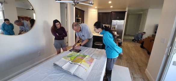
We are fortunate geologists indeed to be able to stay in an Air BnB house in Washington, Utah, during our fieldwork. This morning we started with a briefing about the day’s activities. (Lucie on the left, Vicky on the right.) Note the geological map and stratigraphic sections supplemented by an iPad. (Photo by Nick.)

Our first field task was to find an outcrop for Lucie’s Senior IS project. She is looking at the Co-Op Creek Limestone Member of the Carmel Formation, concentrating on the transition between the informal “lower” portion and the informal “upper” part. This corresponds with the boundary between the (again informal) C and D members of Nielson (1990). The lower member is a distinctive set of supratidal and intertidal facies dominated by stromatolites, some of which were examined by Will Santella (’21) in his Senior IS. We found a nice exposure of these stromatolites just northeast of the Gunlock Reservoir.

Some of these stromatolitic and microbial mat deposits have remarkable burrows filled by a well-sorted calacreous sand that appears to be made mostly of crinoid debris.

Lucie and Vicky examine one of the stromatolite beds.

These lower Carmel Formation units also include well-preserved current ripple marks.

Here we are having lunch at one of our most interesting outcrops so far. These almost white rocks weather very differently than the usual limestones and shales above and below them. Turns out this is an exposure of the lowest rocks of the upper part of the Co-Op Creek Limestone Member. (Photo by Nick.)

This white unit is a sandstone at N 37.282454°, W 113.803273°. We have a hypothesis that the lower-upper transition here marks a Middle Jurassic transgression (when sea level rises relative to the land). Sandstone is very rare in the Carmel Formation, so it is telling us something significant about the transition from intertidal to subtidal environments. Score one important find for our first day.

Lucie demonstrates above how unconsolidated this sand is in places. We can run this sand through our venerable Ro-Tap!

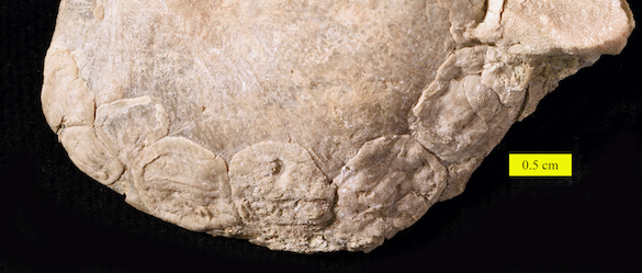
The units immediately above the white sandstone include the familiar ooid shoal deposits of the upper part of the Co-Op Creek Limestone Member. These were studied by Anna Cooke (’20) in her Senior IS project.

A closer view of the ooid shoal deposits and underlying shales.

We will return to these outcrops tomorrow for full measurement, description and sampling.

Nick photographed this blooming prickly pear cactus near our study site today.

And Nick encountered our first rattlesnake of the season! This scary beauty is a Western Diamondback Rattlesnake. I hope it is the last one we see!

The head of this snake with its creepy tongue deserves a close-up!

References: (Which will be useful later.)

Nielson, D.R. 1990. Stratigraphy and sedimentology of the Middle Jurassic Carmel Formation in the Gunlock area, Washington County, Utah. Brigham Young University Geology Studies 36: 153-192.

Sprinkel, D.A., Doelling, H.H., Kowallis, B.J., Waanders, G., and Kuehne, P.A., 2011, Early results of a study of Middle Jurassic strata in the Sevier fold and thrust belt, Utah, in Sprinkel, D.A., Yonkee, W.A., and Chidsey, T.C., Jr., eds., Sevier thrust belt: northern and central Utah and adjacent areas: Utah Geological Association Publication 40, p. 151-172.  

Taylor, P.D. and Wilson, M.A. 1999. Middle Jurassic bryozoans from the Carmel Formation of southwestern Utah. Journal of Paleontology 73: 816–830.

Wilson, M.A. 1998. Succession in a Jurassic marine cavity community and the evolution of cryptic marine faunas. Geology 26: 379–381.

Wilson, M.A. 1997. Trace fossils, hardgrounds and ostreoliths in the Carmel Formation (Middle Jurassic) of southwestern Utah, in Link, P. and Kowallis, B., eds., Mesozoic to recent geology of Utah, Brigham Young University, v. 42, p. 6–9.

Wilson, M.A., Ozanne, C.R. and Palmer, T.J. 1998. Origin and paleoecology of free-rolling oyster accumulations (ostreoliths) in the Middle Jurassic of southwestern Utah, USA. Palaios 13: 70–78.

Posted in Uncategorized | Tagged , , , | Leave a comment

Wooster’s Fossil of the Week: Encrusted strophomenid brachiopods from the Upper Ordovician of northern Kentucky (and the old concave-up or concave-down controversy)

After the delightful Joint North-Central and Southeastern Section Meeting of the Geological Society of America in Cincinnati this month, some of the Wooster Geologists visited a fossiliferous exposure of the Bellevue Formation (Upper Ordovician, Katian) along the Bullitsville Road in northern Kentucky (N 39.08121°, W 84.79230°; C/W-152). In between rainstorms we filled bags with lots of gorgeous fossils. (“Bellevue”, after all, means “beautiful view” in French, and we’re applying that to the view straight down to the ground.) The most common fossil we collected was the strophomenid brachiopod Rafinesquina alternata, an example of which is shown above. (Wooster senior Kate Runciman collected this specimen.)

We are looking above at the dorsal valve exterior of an articulated Rafinesquina alternata, meaning the valves are still joined as they were in life. The dorsal valve is concave, like the shape of your palm with your fingers slightly curled inwards. The hinge (H) of this brachiopod is the straight line at the top of the image. The curved line defining the shape of the brachiopod is the commissure (C), where the valves opened for filter-feeding. Most interesting for us is the encrusting trepostome bryozoan (B) at the bottom of the image. Most of it is on the other side of the brachiopod (see below), but note the clean boundary between its calcitic colony and the commissure of the brachiopod. Clearly the bryozoan grew on the living brachiopod, which continued to feed by opening and closing its valves. The bryozoan did not grow across this commissure, showing it and the brachiopod had a living relationship.

This is the other side of Kate’s brachiopod. We are looking at the ventral valve exterior which is convex (like looking at the back of your hand with fingers curved). The hinge (H) is again at the top. Note that the bryozoan (B) occupies about half of this ventral valve exterior. This shows us that the bryozoan was mostly living on the convex ventral valve, which must have been oriented upwards on the seafloor. This is a nice little fossil vignette supporting the hypothesis that these concave-convex brachiopods lived with the concave side down and the convex side up.

This concave up-or-down question was briefly a fun little controversy, with many debates in the early part of this century. I even covered it in this blog eight years ago. Certainly we can now say that the concave-down argument was won by the Dattilo et al. (2009) and Plotnick et al. (2013) teams.

There was another interesting encrusted Rafinesquina alternata specimen collected that day (above), this one found by Wenshuo Zhao (Fred, ’23). Here we are seeing the convex ventral valve with the hinge (H) at the top. Clustered along the anterior margin is a beautiful set of the encrusting inarticulate brachiopod Petrocrania scabiosa (P). They are irregular patches that have grown against each other like barnacles or oysters. These little brachiopods, which had no hinges between their valves, apparently attached along the margin of this larger brachiopod to take advantage of its feeding currents passing through its commissure. This is another indication of the host brachiopod being encrusted while it was alive, and the arrangement also supports the convex-up living orientation of Rafinesquina alternata.

Here is a closer view of the little Petrocrania scabiosa family.

There are always interesting specimens in bags of Upper Ordovician fossils from the Cincinnati region!

References:

Dattilo, B.F., Meyer, D.L., Dewing, K. and Gaynor, M.R. 2009. Escape traces associated with Rafinesquina alternata, an Upper Ordovician strophomenid brachiopod from the Cincinnati Arch Region. Palaios 24: 578-590.

Plotnick, R.E., Dattilo, B.F., Piquard, D., Bauer, J. and Corrie, J. 2013. The orientation of strophomenid brachiopods on soft substrates. Journal of Paleontology 87: 818-825.

Posted in Uncategorized | Tagged , , , , | 2 Comments

Wooster geologists at the Joint North-Central and Southeastern Section Meeting of the Geological Society of America in Cincinnati

Cincinnati, Ohio —  This week Professor Wiles, Nick Wiesenberg and I attended the 2022 Joint North-Central and Southeastern meeting of the Geological Society of America in Cincinnati, about a three-hour drive south of Wooster. It was quite satisfying to attend such a meeting in person — for me it was my first such gathering since October 2019. The event was held at the Duke Energy Convention Center, a short walk from the Hilton hotel where we all stayed. All attendees had to show proof of Covid vaccinations, and masks were required for all events, but you will notice in these images that masks came off rather frequently.

This isn’t the prettiest picture of Cincinnati, but it was a nice view from the Convention Center of the bridges over the Ohio River into northern Kentucky.

The first Wooster posters of the meeting were presented on Thursday morning by Layali Banna (’22) and Mazvita Chikomo (’22). Their topic title was: “The Community Water Project: Student Exploration of the Geosciences in the Context of Stormwater Management in Northeast Ohio”. They have several coauthors, including Dr. Meagen Pollock, Dr. Greg Wiles, and Nick Wiesenberg. The poster is a summary of this past summer’s AMRE project.

Also on Thursday, Wenshuo Zhao (Fred, ’23) presented a poster entitled: “Voices in the Trees: Seeking Common Stories from Tree Rings in a remote collaboration”. Among his coauthors is Dr.Wiles.

Dr. Greg Wiles gave the first Wooster oral presentation at this meeting on Thursday. His title: “Putting the Recent Pluvial into Context: Tree-Ring Records of Midcontinental North American Hydroclimate.”. His coauthors included Nick Wiesenberg. He gives very animated talks!

Junpeng Fu (Jerry, ’22) presented his poster, “Tree Ring Dating of the Davey Tree Barn, Kent, Ohio, and the Value of Building Long Tree-Ring Records in Ohio”. Coauthors included Dr. Wiles, Nick and Fred.

Mazvita Chikomo (’22) gave the first Wooster student oral presentation on Thursday afternoon: “Modelling Meets Mirror Lake: How Highly Urbanized Areas Influence Surface Water – Groundwater Interactions”.

Friday morning was Kate Runciman’s (’22) turn to give a talk entitled: “Model of a Biotic Hard Substrate Community: Paleoecology of Large Trepostome Bryozoans from the Upper Ordovician (Katian) of the Cincinnati Region, USA”. Her coauthors included Dr. Caroline Buttler, Dr. Shelley Judge, and me.

Ricky Papay (’22) gave his poster on Friday morning: “The Glacial History of Wolf Lake Valley and the Development of a 4000 year Tree Ring Record in Glacier Bay National Park and Preserve, Alaska”. His coauthors included Dr. Wiles and Nick.

The last Wooster presentation was a poster by Justine Paul Berina (’22) entitled: “Unearthing the Effects of European-American Settlement on a Northeast Ohio Kettle Hole Through Diatom Stratigraphy”. Coauthors included Dr. Wiles, Nick, me, and our University of Cincinnati NSF project colleagues. Note his nice suit, which he is still wearing in the field shot below!

A tradition for Wooster Geologists at a meeting is to have a nice dinner together. Nick took this photo of us having a great time in downtown Cincinnati on Thursday evening. Such great conversations. It is such a privilege to have these students in our department and college.

Of course, those Wooster Geologists who stayed until the end of the meeting took advantage of a break in the rain and visited a field site on the way home. This is an exposure of the Bellevue Formation (Upper Ordovician, Katian) along the Bullitsville Road in northern Kentucky (N 39.08121°, W 84.79230°; C/W-152). We collected bags full of brachiopods, bryozoans, crinoids and other delicious fossil groups. Dr. Wiles and I had to practically drag them off the outcrop to get back on the road home. It was so much fun after the long pandemic restrictions on our field activities. Note that Justine Berina is still in his presentation suit because we left the convention center immediately after his poster session!

It was a delightful meeting for all of us. Nick Wiesenberg was of enormous help as a driver and organizer on this trip. Thank you to the GSA staff and volunteers and all our friendly colleagues who made the gathering so collegial and stimulating. The College of Wooster should be especially proud of how well our students presented their research and embodied our institutional values.


Posted in Uncategorized | Tagged , , , | 1 Comment

Unearthing the effects of European-American settlement on a northeast Ohio kettle lake through diatom stratigraphy — The Independent Study project of Justine Paul A. Berina (’22)

Editor’s Note: Independent Study (IS) at The College of Wooster is a three-course series required of every student before graduation. Earth Sciences students typically begin in the second semester of their junior years with project identification, literature review, and a thesis essentially setting out the hypotheses and parameters of the work. Most students do fieldwork or lab work to collect data, and then spend their senior years finishing extensive Senior I.S. theses. Justine Paul A. Berina (’22) had two advisors on his project: Mark Wilson (me!) and Greg Wiles. The following is his thesis abstract —

Recently, wetland conservation has highlighted the necessity for assessing limnological changes following European-American settlement. A prior study at Brown’s Lake (northeast Ohio) identified a stratigraphic sequence that shows an abrupt transition from organic-rich muds to several centimeters of a bright loess layer, then a recovery to organic-rich sediments near the top. Based on 210Pb dates, the loess deposition occurred before 1846 CE, when a growing population cleared trees and farmed intensively. Likewise, organics had recovered after 1950 CE, when people abandoned farmland and practiced conservation tillage. However, the effects of settlement on limnology are poorly known. Diatoms (microscopic algae; class Bacillariophyceae) respond to modifications in water quality and habitat parameters, and siliceous cell walls enable preservation in sediments as fossils. Therefore, a diatom stratigraphy can record the lake’s limnological history. A 1-m sediment core was extracted using a modified-Livingstone sampler and dated using AMS radiocarbon dating. A total of 380 cells from the core were analyzed. The data reveal shifting relative abundances that coincide with settlement activities. Before 880 CE, Thalassiosira sp., a non-motile genus, is dominant, making up 22.1% of diatoms. Between 880 CE and 1950 CE, Achnanthidium sp., a motile genus, is abundant, making up 25.0% of diatoms. It has been noted that the replacement of planktonic genera by diatoms capable of moving through fine sediments suggests a time of excess siltation. From 1950 CE to the present-day, Cyclotella sp., a non-motile genus, is dominant, making up 30% of diatoms. Despite these associations, the data cannot provide evidence of a cause-and-effect relationship due to confounding variables (e.g., climate, habitat availability, and structures), errors, and limitations. This study offers the first catalog of historical and modern diatom assemblages at Brown’s Lake to support conservation initiatives.

The diatom pictured at the top of this page is Gomphonema sp. The diatom immediately above is Navicula sp. Both images were taken by Justine using an oil immersion lens with our photomicroscopes.

Here is hardworking Justine on Brown’s Lake. Congratulations on completing a successful IS project!

Posted in Uncategorized | Tagged , , | Leave a comment

Model of a Biotic Hard Substrate Community: Paleoecology of Large Trepostome Bryozoans from the Upper Ordovician (Katian) of the Cincinnati Region, USA — The Independent Study project of Kate Runciman (’22)

Editor’s Note: Independent Study (IS) at The College of Wooster is a three-course series required of every student before graduation. Earth Sciences students typically begin in the second semester of their junior years with project identification, literature review, and a thesis essentially setting out the hypotheses and parameters of the work. Most students do fieldwork or lab work to collect data, and then spend their senior years finishing extensive Senior I.S. theses. Kate Runciman (’22) was the first in our department to submit her thesis (#7 in the College!). Kate had three advisors on her project: Mark Wilson (me!), Shelley Judge, and Caroline Buttler of the National Museum Wales. The following is her thesis abstract —

The calcite skeletons of trepostome bryozoan colonies from the Upper Ordovician (Katian) of the Cincinnati region record the diverse interactions and growth responses these colonies experienced. Trepostome specimens from three Cincinnatian strata; the Bellevue Member, the Bull Fork Formation, and the Whitewater Formation, were studied within this project. These three strata were deposited in a shallow epicontinental sea environment that was located in the southern subtropics, approximately 20-23°S at the time of deposition. The focus of this project was the paleoecology of large trepostome bryozoans, which was studied by examining bryozoan growth patterns, trace fossils, and sedimentation. Microscopic examination of these features was conducted by sectioning colonies and making acetate peels and thin sections. Through this examination many trace fossils were found, with Trypanites borings being the most common. These borings often contained calcite “ghosts” and appear to have been excavated mechanically by a worm such as a sipunculan or phoronid. A subset of the observed borings prompted growth reactions in their host bryozoan, indicating that these borings progressed through a live portion of the colony. Growth reactions served to seal the cavity and regain feeding surfaces by: (1) Zooids surrounding the cavity growing upwards and angling inwards, creating a “tent” with the cavity closed off; (2) Zooids growing laterally over the cavity opening, sealing it off with a flat “roof”; or (3) Zooids budding down into the cavity then angling upwards, filling in all open space and resuming a feeding surface above. Other features observed in the trepostomes studied include calcite tubes, which are interpreted as fossil cornulitids; a tube and holdfast, interpreted as a sphenothallid; and prismatic calcite features, which are interpreted as the remains of aragonitic shells. All colonies and trace fossils included in this study were infilled with one or more of: sparry calcite cement, dolomite rhombs, biosparite, micrite, prismatic calcite, and phosphate. This range of infilling materials suggests that infilling processes were episodic. The episodic nature of these processes allowed for the preservation of ghosts and occasionally geopetal structures. Internal surfaces were observed that indicated regions of self-overgrowth in the colony. These self-overgrowths were commonly associated with brown bodies. Work continues to combine insights provided by the trace fossils, growth responses, and infill observed in the Cincinnatian trepostomes to interpret the ecology and life modes of these bryozoans.

The image at the top is a thin-section longitudinal view of one of Kate’s bryozoans. It shows a bioclaustration of a soft-bodied encruster, most likely a sphenothallid. Location C/W-152.

This longitudinally-cut thin-section shows bryozoan zooecia with terminal diaphragms below a discontinuity and self-overgrowth. The terminating chambers contain remnants of the original soft-bodied bryozoan zooids (or polypides) known as “brown bodies“. Location C/W-153 (Bull Fork Formation near Maysville, Mason County, Kentucky; 38º 35.111′ N, 083º 42.094′ W).

And here’s Kate with an especially large trepostome bryozoan colony. Congratulations on a successful project!

[Editor’s note (July 26, 2023): Kate has been accepted into the palaeontology PhD program at the University of Cambridge. Full scholarship!]

Posted in Uncategorized | Tagged , , | Leave a comment